The term "United States", when used in the geographical sense, is the contiguous United States, the state of Alaska, the island state of Hawaii, the five insular territories of Puerto Rico, Northern Mariana Islands, U.S. Virgin Islands, Guam, and American Samoa, and minor outlying possessions. The United States shares land borders with Canada and Mexico and maritime borders with Russia, Cuba, and the Bahamas in addition to Canada and Mexico. The northern border of the United States with Canada is the world's longest bi-national land border.

California is a U.S. state on the western coast of North America. Covering an area of 163,696 sq mi (423,970 km2), California is geographically diverse. The Sierra Nevada, the fertile farmlands of the Central Valley, and the arid Mojave Desert of the south are some of the major geographic features of this U.S. state. It is home to some of the world's most exceptional trees: the tallest, most massive, and oldest. It is also home to both the highest and lowest points in the 48 contiguous states. The state is generally divided into Northern and Southern California, although the boundary between the two is not well defined. San Francisco is decidedly a Northern California city and Los Angeles likewise a Southern California one, but areas in between do not often share their confidence in geographic identity. The US Geological Survey defines the geographic center of the state at a point near North Fork, California.
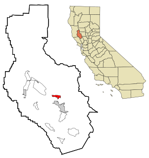
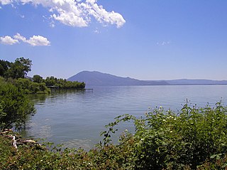
Clearlake Oaks is a census-designated place (CDP) in Lake County, California, United States. It is located on the extreme southeast of Clear Lake, 13 miles (20.8 km) east-southeast of Lakeport, at an elevation of 1,335 feet. The population was 2,359 at the 2010 census, down from 2,402 at the 2000 census.
U.S. Route 97 is a major north–south United States highway in the western United States. It begins at a junction with Interstate 5 at Weed, California, and travels north, ending in Oroville in Okanogan County, Washington, at the Canada–US border, across from Osoyoos, British Columbia, becoming British Columbia Highway 97 upon entering Canada. Major cities that lie on US 97 include Klamath Falls, Bend, and Redmond in Oregon and Yakima, Ellensburg, and Wenatchee in Washington.

Area code 707 is a California telephone area code that was split from area code 916 on March 1, 1959. It covers the northwestern portion of the state of California. It serves part of the northern San Francisco Bay Area, as well as the North Coast and the northwestern portion of the state. Major cities in the area code include Napa, Sebastopol, Vallejo, Benicia, Fairfield, Santa Rosa, Windsor, Healdsburg, Rohnert Park, Petaluma, Fort Bragg, Crescent City, Eureka, Clearlake, Vacaville, Ukiah, and northwestern California. In addition, when area code 916 split into area code 530 on November 1, 1997, the Dixon area moved from area code 916 to 707 and also from the Sacramento LATA into the San Francisco LATA.
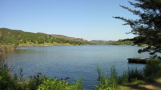
Santa Margarita Lake, also called Salinas Reservoir, is a lake several miles southeast of the town of Santa Margarita in San Luis Obispo County, California. The lake was created by the building of Salinas Dam on the southern end of the Salinas River, very close to the river's origin in the Santa Lucia Range.
M. Penn Phillips, born Marion Phillips, was an American entrepreneur and prominent real estate developer.

The geography of New York state varies widely. Most of New York is dominated by farms, forests, rivers, mountains, and lakes. New York's Adirondack Park is larger than any U.S. National Park in the contiguous United States. Niagara Falls, on the Niagara River as it flows from Lake Erie to Lake Ontario, is a popular attraction. The Hudson River begins near Lake Tear of the Clouds and flows south through the eastern part of the state without draining lakes George or Champlain. Lake George empties at its north end into Lake Champlain, whose northern end extends into Canada, where it drains into the Richelieu River and then the St. Lawrence. Four of New York City's five boroughs are on the three islands at the mouth of the Hudson River: Manhattan Island, Staten Island, and Brooklyn and Queens on Long Island.

Lake Transit is a bus agency providing fixed-route, flex-stop and curbside "Dial-a-Ride" bus service in Lake County, California. The agency also provides service to Ukiah in Mendocino County and St. Helena in northern Napa County.
The Borax Lake Site, also known as the Borax Lake—Hodges Archaeological Site and designated by the Smithsonian trinomial CA-LAK-36, is a prehistoric archaeological site near Clearlake, California. The site, a deeply stratified former lakeshore, contains evidence of the earliest known period of human habitation in what is now California, dating back 12,000 years. A portion of the site, designated a National Historic Landmark in 2006, is owned and preserved by the Archaeological Conservancy.

Tierra Redonda Mountain is a mountain in northwestern San Luis Obispo County, California. It is in the eastern portion of the Santa Lucia Range, separated from the main ridge by the Nacimiento River.

Clearlake Riviera is a census-designated place in Lake County, California. It lies at an elevation of 1755 feet. The population was 3,090 at the 2010 census.

Clearlake Park is a former unincorporated community now incorporated in Clearlake, in Lake County, California. It is located on the north shore of the southeast end of Clear Lake, just north of the village of Clearlake Highlands and about 15 miles (24 km) east-southeast of Lakeport, at an elevation of 1362 feet.

Glenhaven is an unincorporated community in Lake County, California. It is located on Clear Lake 3 miles (4.8 km) west of Clearlake Oaks, at an elevation of 1345 feet.

North Dallas is an area of numerous communities and neighborhoods in Dallas, Texas. The phrase "North Dallas" is also sometimes used to include any suburb or exurb north of Dallas proper within the metropolitan area. The majority of North Dallas is located in Dallas County, while a small portion is located in Collin and Denton Counties. North Dallas generally includes areas of Dallas north of Northwest Highway, along with Lake Highlands and areas of Dallas north of IH-635 known as Far North Dallas. The area has strong social and economic ties to the Dallas enclave of Park Cities, and two inner suburbs of Dallas, Richardson and Addison. It is the wealthiest part of Dallas, but has its adjacent, less resourced areas as well.
The Koi Nation of the Lower Lake Rancheria is a federally recognized tribe of Southeastern Pomo people in Sonoma County, California. Their name for their tribe is Koi Nation of Northern California, from their traditional village, Koi, once located on an island in Clear Lake. Koi, meaning people of water, lived on islands in the Clear Lake in what is now Lake County, California, and migrated seasonally to the California coast. The "Purvis Tract" is located on the Northwest corner of the Clear Lake. For thousands of years, the Nation lived under the Purvis Tract. In that time, the nation continued to assert its unique identity and maintain control of its area.

The Clayton Fire was a wildfire that started on August 13, 2016 just south of Lower Lake in Lake County, California. The fire burned a total of 3,929 acres (15.90 km2) and destroyed 300 buildings, before it was fully contained on August 26. Damin Pashilk, a construction worker from Clearlake was arrested and facing 17 counts of arson related to the Clayton Fire and other fires.