Related Research Articles

Ahtanum is a census-designated place (CDP) in Yakima County, Washington. The population was 4,046 at the time of the 2020 census.

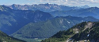
The Wenatchee Mountains are a range of mountains in central Washington State, United States of America. A major subrange of the Cascade Range, extending east 50 miles (80 km) from the Cascade crest, the Wenatchee Mountains separate the drainage basins of the Yakima River from the Wenatchee River. The crest of the range forms part of the boundary between Chelan and Kittitas Counties.
The Chiwaukum Mountains are a north–south mountain range in central Washington, United States. They stretch from Snowgrass Mountain at 47°41′N120°56′W, to 47°45′N120°54′W.
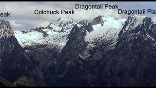
The Stuart Range is a mountain range in central Washington, United States. The range lies within the eastern extent of the Cascade Range immediately southwest of Leavenworth and runs east–west. The western peaks make up a single sharp ridge. The eastern half of the range splits into two parallel ridges, the northern of which is known as the Enchantment Peaks. Between these ridges lies the Enchantment Basin, which holds the dozens of tarns known as the Enchantment Lakes. Collectively, the basin and the encircling eastern peaks of the Stuart Range make up The Enchantments, a well-known backpacking destination. The south face of the Stuart Range falls off steeply to Ingalls Creek, beyond which rise the roughly parallel Wenatchee Mountains.

The Northwestern United States, also known as the American Northwest or simply the Northwest, is an informal geographic region of the United States. The region consistently includes the states of Oregon, Washington, Idaho, Montana and Wyoming. Some sources include Southeast Alaska in the Northwest. The related but distinct term "Pacific Northwest" generally excludes areas from the Rockies eastward, whereas the term "Inland Northwest" excludes areas west of the Cascades.
Erg Mountain Provincial Park is a provincial park in British Columbia, Canada.
Greenstone Mountain Provincial Park is a provincial park in British Columbia, Canada, located south of Kamloops Lake on the northern edge of the Thompson Plateau.

Washington Pass and Rainy Pass are two mountain passes on State Route 20 in the North Cascades mountains of Washington state. Rainy Pass is about 4 miles to the west of Washington Pass. The passes are typically closed between November and April due to heavy snowfall.

Manastash Ridge is a long anticline mountain ridge located in central Washington state in the United States. Manastash Ridge runs mostly west-to-east in Kittitas and Yakima counties, for approximately 50 miles. The ridge is part of the Yakima Fold Belt of east-tending long ridges formed by the folding of Miocene Columbia River basalt flows.

The Columbia Hills are an area of hills and small mountains along the north bank of the Columbia River in Klickitat County, in south-central Washington state, US. They have a maximum elevation of 2,667 feet (813 m).

Ahtanum Ridge is a long anticline mountain ridge in Yakima County in the U.S. state of Washington. It is located just south of the city of Yakima, and much of its length is at the northern edge of the Yakama Indian Reservation. Its name comes from the Sahaptin toponym [átanɨm].

Umtanum Ridge is a long anticline mountain ridge in Yakima County and Kittitas County in the U.S. state of Washington. It runs for approximately 55 miles east-southeast from the Cascade Range, through the Yakima Training Center to the edge of the Columbia River at Priest Rapids Dam and Hanford Reach. The eastern end of Umtanum Ridge enters Hanford Reach National Monument and the Hanford Site. Umtanum Ridge is paralleled on the north by Manastash Ridge and on the south by Yakima Ridge. The Yakima River cuts through the ridge at the Umtanum Ridge Water Gap.
The Manastash Ridge Radar is a passive radar which uses commercial FM broadcasts to study ionospheric turbulence as well as meteor trails, and aircraft. The radar is passive and bistatic; there are receivers located at the University of Washington as well as at Manastash Ridge, which are synchronized to permit coherent operation.
Snipes Mountain is an American Viticultural Area (AVA) located in the Yakima Valley of Washington state. It was established by the Alcohol and Tobacco Tax and Trade Bureau (TTB), Treasury on January 21, 2009 as the state's 10th AVA. It is the second smallest AVA in the state, after the Red Mountain AVA, and has one of the state's longest viticultural histories. The 4,145 acres (6 sq mi) appellation is a sub-AVA of the Yakima Valley AVA and the Columbia Valley AVA. It is located above and between the towns of Sunnyside and Granger around Outlook, Washington, in the southeast corner of the Yakima Valley.

Kautz Creek is a tributary of the Nisqually River, flowing from the Kautz Glacier, with its watershed in the Mount Rainier National Park of Washington. It drains southwest from Mount Rainier for about 6 miles (9.7 km) before it joins the Nisqually River near Mount Rainier Highway. It is notable for being a severe flooding hazard due to the volume of summer glacier melt and its frequently changing course. The 400-foot (120 m) Kautz Creek Falls on the headwaters of the creek was formed by the retreat of the Kautz Glacier in the past 50 years.

Galium serpenticum is a species of flowering plant in the coffee family (Rubiaceae) known by the common name intermountain bedstraw or many-flowered bedstraw.

The Clearwater River is in the northwestern United States, in north central Idaho. Its length is 74.8 miles (120.4 km), it flows westward from the Bitterroot Mountains along the Idaho-Montana border, and joins the Snake River at Lewiston. In October 1805, the Lewis and Clark Expedition descended the Clearwater River in dugout canoes, putting in at "Canoe Camp," five miles (8 km) downstream from Orofino; they reached the Columbia Bar and the Pacific Ocean about six weeks later.
Camp Wooten Retreat Center is a group camp in the Washington State Park System located fifteen miles south of Pomeroy in Columbia County, Washington. It consists of a 1930s-era dining hall and many cabins and other facilities on the Tucannon River and Donnie Lake in the Blue Mountains. Available activities include indoor swimming, canoeing on the lake, hiking, archery and other athletic facilities.
Thrall is an unincorporated community in Kittitas County, in the U.S. state of Washington.
References
- ↑ U.S. Geological Survey Geographic Names Information System: Cleman Mountain
- ↑ Meany, Edmond S. (1923). Origin of Washington geographic names. Seattle: University of Washington Press. p. 50.
46°49′11″N120°50′57″W / 46.8198444°N 120.8492423°W
| | This Yakima County, Washington state location article is a stub. You can help Wikipedia by expanding it. |