Macon County is a county located in the U.S. state of North Carolina. As of the 2010 census, the population was 33,922. Its county seat is Franklin.

Graham County is a county located in the U.S. state of North Carolina. As of the 2010 census, the population was 8,861, making it the third-least populous county in North Carolina. Its county seat is Robbinsville. The county was formed January 30, 1872, from the northeastern part of Cherokee County. It was named for William A. Graham, United States Senator from North Carolina (1840–1843) and Governor of North Carolina (1845–1849).
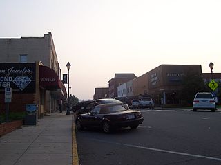
Franklin is a town in Franklin Township, Macon County, North Carolina, United States, within the Nantahala National Forest. The population was 3,845 as of the 2010 census. It is the county seat of Macon County. Franklin is an official Appalachian Trail-friendly destination. The Franklin area is rich in gems and minerals and is known locally as the "Gem Capital of The World."

Highlands is an incorporated town in Macon County in the U.S. state of North Carolina. Located on a plateau in the southern Appalachian Mountains, within the Nantahala National Forest, it lies mostly in southeastern Macon County and slightly in southwestern Jackson County, in the Highlands and Cashiers Townships, respectively. The permanent population was 924 at the 2010 census.
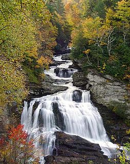
The Cullasaja River is a short river located entirely in Macon County, North Carolina. It is a tributary of the Little Tennessee River, into which it flows near the county seat of Franklin. It originates to the southeast, near Highlands, the county's only other town. It flows from manmade Lake Sequoyah, which is fed by Mirror Lake and other creeks and streams originating on the western side of the Eastern Continental Divide, which runs through the east side of Highlands.
The Cherokee National Forest is a large National Forest created on June 14, 1920 and managed by the U.S. Forest Service and encompassing some 655,598 acres (2,653.11 km2).

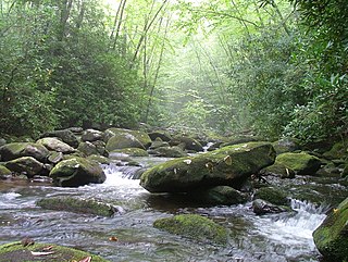
The Nantahala River is a river in western North Carolina in the United States, within the Nantahala National Forest, and near the Great Smoky Mountains National Park. Two-lane U.S. Highway 19/74, once part of the Trail of Tears, runs along the river, picnic areas dotting the route.
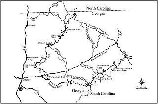
The Bartram Trail follows the approximate route of 18th-century naturalist William Bartram’s southern journey from March 1773 to January 1777. Bartram explored much of the territory which is now the states of North and South Carolina, Georgia, Florida, Alabama, Mississippi, Louisiana and Tennessee.

The Skylands Region is a region and marketing area of the State of New Jersey located in the Northern and Central part of the state. It is one of six tourism regions established by the New Jersey State Department of Tourism, the others being the Gateway Region, Greater Atlantic City Region, the Southern Shore Region, the Delaware River Region and the Shore Region. The area officially encompasses Hunterdon, Morris, Somerset, Sussex and Warren counties; the northwestern part of the Passaic County fits in with the Skylands Region, but it is part of the Gateway Region and not the Skylands Region. One could also say that the western most part of Bergen is also part of the skylands. The area features uplifted land, rolling hills and mountains characteristic of North Jersey. The region contains 60,000 acres of state parkland, and a diverse geography filled with lakes, rivers and picturesque hills.

Nantahala Outdoor Center (NOC) is a commercial outdoor guide service and retail store. It opened in 1972 when Payson and Aurelia Kennedy and Horace Holden Sr. took over the old Tote 'N Tarry Motel. NOC is based in western North Carolina near Bryson City, near the Great Smoky Mountains on the Nantahala River. NOC is surrounded by Nantahala National Forest. The Appalachian Trail passes directly through the heart of the NOC, crossing the Nantahala River on a bridge next to the outfitter.

The Southern Nantahala Wilderness was designated in 1984 and currently consists of 23,473 acres (94.99 km2). Approximately 11,770 acres (47.6 km2) are located in Georgia in the Chattahoochee National Forest and approximately 11,703 acres (47.36 km2) are located in North Carolina in the Nantahala National Forest. The Wilderness is managed by the United States Forest Service and is part of the National Wilderness Preservation System. The highest elevation in the Southern Nantahala Wilderness is the 5,499-foot peak of Standing Indian Mountain in North Carolina and the lowest elevation is approximately 2,400 feet (730 m). The Appalachian Trail passes through the Wilderness in both states.

Rich Knob, elevation 4,152 feet, is located in Towns County, Georgia. It is part of the Georgia portion of the Southern Nantahala Wilderness and is within the boundaries of the Tallulah Ranger District of the Chattahoochee National Forest. The mountain lies along the Appalachian Trail, which crosses over its eastern flank in Rabun County as it enters North Carolina.

Ellicott Rock Wilderness is managed by the United States Forest Service and is part of the National Wilderness Preservation System. It was first designated by Congress in 1975 with the Eastern Wilderness Act. The majority of this land lays in South Carolina. Additional lands were added to Ellicott Rock Wilderness in 1984 with the passing of the North Carolina Wilderness Act and the Georgia Wilderness Act, today designated wilderness totals 8,274 acres (33.48 km2). Ellicott Rock Wilderness is the only wilderness that straddles three states, with boundaries located around the point at which Georgia, North Carolina, and South Carolina come together. Ellicott Rock Wilderness also spans three National Forests. Sumter National Forest in South Carolina is responsible for 2,859 acres (11.57 km2), receives the majority of recreation in the wilderness, and also acts as the lead manager of Ellicott Rock Wilderness. Nantahala National Forest in North Carolina is responsible for the majority of the wilderness at 3,394 acres (13.74 km2) and the Chattahoochee National Forest in Georgia manages 2,021 acres (8.18 km2) of wilderness. In 1979, Forest Service land was surveyed under the Roadless Area Review and Evaluation and 1,982 acres (8.02 km2) adjacent to the existing wilderness were classified as Roadless National Forest System land, named Ellicott Rock Extension. The Andrew Pickens Ranger district on the Sumter National Forest recommended the Ellicott Rock Extension as wilderness in 1995 in their Resource Management Plan. In June of 2017 during a land management plan revision, the Nantahala Ranger District on the Nantahala National Forest added 824 acres (3.33 km2) of proposed wilderness, currently called Ellicott Rock West Extension.

Shuckstack is a mountain in the Great Smoky Mountains of Swain County, North Carolina, in the southeastern United States. It has an elevation of 4,024 feet (1,227 m) above sea level, and rises approximately 2,300 feet (700 m) above Fontana Lake, to the south.

Scaly Mountain is also a small unincorporated community along North Carolina highway 106, southwest of Highlands, North Carolina and northeast of Dillard, Georgia, and nearest to Sky Valley, Georgia just to the south-southwest. It is in far south-southwest Macon County, North Carolina, in Flats Township, close to the Georgia and North Carolina state line.

Wayah Bald is a high-altitude treeless open area in Nantahala National Forest, near Franklin, North Carolina. The Wayah Bald Observation Tower is located at the area's highest point ; the stone observation tower was built by the Civilian Conservation Corps in 1937 for fire detection. The Appalachian Trail and Bartram Trail cross at Wayah Bald.

Wesser Bald is a summit located in Macon County, North Carolina, near the community of Wesser. A wooden fire tower at the summit provides hikers with unimpeded views of the Great Smoky Mountains National Park and also the Nantahala Mountains. The Appalachian Trail traverses the summit from roughly north to south with the Nantahala Outdoor Center lying to the north within the Nantahala Gorge and Tellico gap just to the south. Tellico gap has unimproved road access. The climb from Tellico Gap takes an average of 20 minutes. Also, a third route, the blue trail, departs from the end of Wesser Creek Road and follows Wesser Creek up to a point just south of the summit to a fork with the Appalachian Trail. The summit is located at 4,627 ft (1,410 m). and is within Nantahala National Forest. A map detailing the highway routes to access Tellico Gap is available at the Nantahala Outdoor Center. Observable landforms include Wayah Bald, the Nantahala Gorge, and Clingmans Dome among others. The Wesser Fire Tower provides unparalleled 360 degree views of the Smokies in a short 1.5 mile hike from Tellico Gap on the Appalachian Trail, with an elevation gain of about 767 feet. The Fire Tower was originally reported as destroyed during the forest fires which ravaged the Nantahala Forest in November, 2016 but it was later learned that it survived.

The Southern Highroads Trail is a 364-mile loop of scenic and historic highways in the Southeastern United States. The driving trail traverses 14 counties, four states, and four national forests, providing sightseers and passersby an array of culinary, hotel, shopping and recreational options along the way.

Nantahala Township is located in North Carolina in the part of Macon County which is west of Wayah Gap. It has a population of 1,711. "Nantahala" is a Cherokee word which means "Land of the Noonday Sun." The area fits its name because in a few spots, the sun's rays only reaches the floors of the Nantahala National Forest when it is directly overhead during the middle of the day.