
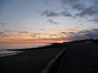
Climping Sand Dunes are a system of dunes at Climping in the Arun District of West Sussex, England located west of Littlehampton. [1] The eastern end of the dunes adjoins the River Arun and Littlehampton Redoubt.
Climping Sand Dunes are a system of dunes at Climping in the Arun District of West Sussex, England located west of Littlehampton. [1] The eastern end of the dunes adjoins the River Arun and Littlehampton Redoubt.
Vegetation such as Marram Grass is essential for dunes to work, dominating the stabilised parts of the dunes. [2] Other grasses that grow there include Dune Fescue and Red Fescue. Dogs off leads can easily run around the dunes, and destroy the vegetation. Horses being ridden over the dunes will have a similar effect. The Climping dunes are an SSSI (Site of Special Scientific Interest). In 2006 the total number of full species at Climping Gap stood at 256.[ citation needed ] It supports important populations of wintering birds and the numbers of wintering Sanderling, in particular, are of European significance. Vegetated shingle beaches are a nationally uncommon habitat. [3] The beach at Climping is broad in the west but narrows to the east. Plant communities include Yellow horned poppy, Sea Kale, Sea Beet, Curled Dock, Eryngium maritimum, Sand Catchfly, Viper's Bugloss and Nottingham Catchfly.

A dune is a landform composed of wind- or water-driven sand. It typically takes the form of a mound, ridge, or hill. An area with dunes is called a dune system or a dune complex. A large dune complex is called a dune field, while broad, flat regions covered with wind-swept sand or dunes, with little or no vegetation, are called ergs or sand seas. Dunes occur in different shapes and sizes, but most kinds of dunes are longer on the stoss (upflow) side, where the sand is pushed up the dune, and have a shorter slip face in the lee side. The valley or trough between dunes is called a dune slack.

Holkham National Nature Reserve is England's largest national nature reserve (NNR). It is on the Norfolk coast between Burnham Overy Staithe and Blakeney, and is managed by Natural England with the cooperation of the Holkham Estate. Its 3,900 hectares comprise a wide range of habitats, including grazing marsh, woodland, salt marsh, sand dunes and foreshore. The reserve is part of the North Norfolk Coast Site of Special Scientific Interest, and the larger area is additionally protected through Natura 2000, Special Protection Area (SPA) and Ramsar listings, and is part of both an Area of Outstanding Natural Beauty (AONB) and a World Biosphere Reserve. Holkham NNR is important for its wintering wildfowl, especially pink-footed geese, Eurasian wigeon and brant geese, but it also has breeding waders, and attracts many migrating birds in autumn. Many scarce invertebrates and plants can be found in the dunes, and the reserve is one of the only two sites in the UK to have an antlion colony.

Littlehampton is a town, seaside resort and civil parish in the Arun District of West Sussex, England. It lies on the English Channel on the eastern bank of the mouth of the River Arun. It is 52 miles (84 km) south south-west of London, 19 miles (31 km) west of Brighton and 10 miles (16 km) east of Chichester.

The River Arun is a river in the English county of West Sussex. At 37 miles (60 km) long, it is the longest river entirely in Sussex and one of the longest starting in Sussex after the River Medway, River Wey and River Mole. From the series of small streams that form its source in the area of St Leonard's Forest in the Weald, the Arun flows westwards through Horsham to Nowhurst where it is joined by the North River. Turning to the south, it is joined by its main tributary, the western River Rother, and continues through a gap in the South Downs to Arundel to join the English Channel at Littlehampton. It is one of the faster flowing rivers in England, and is tidal as far inland as Pallingham Quay, 25.5 miles (41.0 km) upstream from the sea at Littlehampton. The Arun gives its name to the Arun local government district of West Sussex.

Arun is a local government district in West Sussex, England. Its council is based in Littlehampton. The district's other towns are Arundel and Bognor Regis. The district is named after the River Arun, which runs through the centre of the district. Parts of the district fall within the South Downs National Park.

Littlehampton Redoubt, usually known as Littlehampton Fort, was built in 1854 to protect the entrance to the River Arun at Littlehampton on the south coast of England, against possible attack by the French under the Emperor Napoleon III. There had been a previous battery on the east bank of the river, but the new fort was built on the west bank. It consisted of a platform from which cannon could sweep the harbour mouth, with a barracks behind and a surrounding defensive ditch and wall. The fort was an innovative military structure, incorporating the new feature of a Carnot wall. Its active use as a fort was short at only about 20 years, owing to technical changes in armaments, but it was a precursor of the later Palmerston Forts and therefore is NOT the First Palmerston Fort as has been alleged. The Palmerston Forts were built after the 1860 commission. Littlehampton Fort is now in a ruinous and overgrown state but largely protected by the Ivy that now grows over the walls.

Bognor Regis and Littlehampton is a constituency in West Sussex represented in the House of Commons of the UK Parliament since 2024 by Alison Griffiths, a Conservative.

The estuaries of the River Ribble and River Alt lie on the Irish Sea coasts of Lancashire and Merseyside in North West England. Together they, and the area of salt marsh, mudflats, and sand dunes between them, form a Special Protection Area and Ramsar site which covers the coastline between Crosby and Lytham St Annes. These protected areas overlap with two sites of special scientific interest, Ribble Estuary and Sefton Coast.
Climping is a village and civil parish containing agricultural and natural sandy land in the Arun District of West Sussex, England. The parish also contains the coastal hamlet of Atherington. It is three miles (5 km) west of Littlehampton, just north of the A259 road.

Ammophila arenaria is a species of grass in the family Poaceae. It is known by the common names marram grass and European beachgrass. It is one of two species of the genus Ammophila. It is native to the coastlines of Europe and North Africa where it grows in the sands of beach dunes. It is a perennial grass forming stiff, hardy clumps of erect stems up to 1.2 metres (3.9 ft) in height. It grows from a network of thick rhizomes which give it a sturdy anchor in its sand substrate and allow it to spread upward as sand accumulates. These rhizomes can grow laterally by 2 metres in six months. One clump can produce 100 new shoots annually.
The Durham Coast is a Site of Special Scientific Interest in County Durham, England. Starting just North of the River Tees estuary it extends, with a few interruptions, northward to the mouth of the River Tyne at South Shields. Notable locations on the Durham Coast include Hartlepool Headland, Seaham, Sunderland Docks and Whitburn Beach.

Sand dune ecology describes the biological and physico-chemical interactions that are a characteristic of sand dunes.
NVC community SD19 is one of the 16 sand-dune communities in the British National Vegetation Classification system. It is one of six communities associated with foredunes and mobile dunes.

Sussex is a historic county and cultural region in the south of England corresponding roughly in area to the ancient Kingdom of Sussex. It is bounded on the north by Surrey, north-east by Kent, south by the English Channel, and west by Hampshire, and is divided for local government into West Sussex and East Sussex and the city of Brighton and Hove. The city of Brighton & Hove was created a unitary authority in 1997, and was granted City status in 2000. Until then Chichester had been Sussex's only city. By convention, Chichester is Sussex's capital city and Lewes is Sussex's county town.

Middleton is an electoral division of West Sussex in the United Kingdom and returns one member to sit on West Sussex County Council.

Ireland is in the Atlantic European Province of the Circumboreal Region, a floristic region within the Holarctic.

Bailiffscourt Chapel is a deconsecrated chapel in the grounds of Bailiffscourt Hotel, a luxury hotel near the hamlet of Atherington in West Sussex, England. Originally associated with the Norman Abbey of Séez, it was founded in the 11th century and rebuilt in its present simple Gothic form in the 13th century. It later fell out of use, but after Atherington's former church was destroyed by coastal erosion it was used again for public worship for a time—and as late as 1952 the building was again in use as a chapel of ease. Situated outside Bailiffscourt—a mock-medieval mansion built in 1935 by Lord Moyne on the site of an ancient manor house—on the only stretch of open seafront land for miles in each direction, the chapel is now used principally for wedding and civil ceremony blessings. English Heritage has listed it at Grade II* for its architectural and historical importance.

The North Norfolk Coast Site of Special Scientific Interest (SSSI) is an area of European importance for wildlife in Norfolk, England. It comprises 7,700 ha (19,027 acres) of the county's north coast from just west of Holme-next-the-Sea to Kelling, and is additionally protected through Natura 2000, Special Protection Area (SPA) listings; it is also part of the Norfolk Coast Area of Outstanding Natural Beauty (AONB). The North Norfolk Coast is also designated as a wetland of international importance on the Ramsar list and most of it is a Biosphere Reserve.
Climping Beach is a 32.1-hectare (79-acre) biological Site of Special Scientific Interest west of Littlehampton in West Sussex. The eastern half is designated a Local Nature Reserve called West Beach.
50°48′02″N0°33′02″W / 50.80056°N 0.55056°W
| | This West Sussex location article is a stub. You can help Wikipedia by expanding it. |