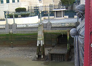
The River Effra is a former stream or small river in south London, England, now culverted for most of its course. Once a tributary of the River Thames, flows from the Effra were incorporated in the Victorian era into a combined sewer draining much of the historic area of Peckham and Brixton.

The London sewerage system is part of the water infrastructure serving London, England. The modern system was developed during the late 19th century, and as London has grown the system has been expanded. It is currently owned and operated by Thames Water and serves almost all of Greater London.

Mersea Island is an island in Essex, England, in the Blackwater and Colne estuaries to the south-east of Colchester. Its name comes from the Old English word meresig, meaning "island of the pool" and thus is tautological. The island is split into two main areas, West Mersea and East Mersea, and connected to the mainland by the Strood, a causeway that can flood at high tide.
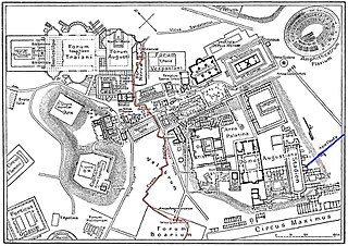
The Cloaca Maxima has constituted one of the world's earliest sewage systems. Constructed in Ancient Rome in order to drain local marshes and remove the waste of one of the world's most populous cities, it carried effluent to the River Tiber, which ran beside the city.

The Tank Stream is a heritage-listed former fresh water tributary of Sydney Cove and now tunnel and watercourse located in the Sydney central business district, in the City of Sydney local government area of New South Wales, Australia. The Tank Stream was the fresh water supply for the fledgling colony of New South Wales in the late 18th century. Today it is little more than a storm water drain. It originated from a swamp to the west of present-day Hyde Park and at high tide entered Sydney Cove at what is now the intersection of Bridge and Pitt Streets in the Sydney central business district. The catchment was 65 hectares, corresponding roughly the size of the Sydney central business district. It was added to the New South Wales State Heritage Register on 2 April 1999.

Villa Jovis is a Roman palace on Capri, southern Italy, built by emperor Tiberius and completed in AD 27. Tiberius mainly ruled from there until his death in AD 37.
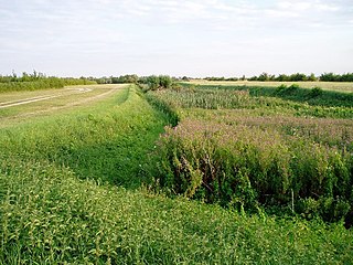
The Car Dyke was, and to a large extent still is, a 85 miles (137 km)-long ditch which runs along the western edge of the Fens in eastern England. It is generally accepted as being of Roman age and, for many centuries, to have been taken as marking the western edge of the Fens. There, the consensus begins to break down.

Sewer alligator stories date back to the late 1920s and early 1930s; in most instances they are part of contemporary legend. They are based upon reports of alligator sightings in rather unorthodox locations, in particular New York City.
The island of Capri is situated in the Gulf of Naples, between the Italian Peninsula and the islands of Procida and Ischia. Made of limestone, its lowest part is at the center, while its sides are high and mostly surrounded by steep precipices, which contain numerous caves. Its topography is dominated by the slopes of the Monte Solaro in the West and Mont-Saint-Michel in the East.
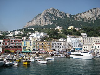
Capri is a municipality, in the Metropolitan City of Naples, situated on the island of Capri in Italy. It comprises the centre and East of the island, while the West belongs to Anacapri.

The Chiesa di San Costanzo is a monumental church of Capri. Named after the patron saint of the island of Capri, San Costanzo, it was the cathedral of the Roman Catholic Diocese of Capri from 987–1560.
Palazzo a Mare is a well-preserved ancient Roman archaeological site on the north side of the island of Capri, consisting of an imperial palace built by Augustus and modified by Tiberius. It was one of the supposed 12 villas of Tiberius on the island as described by Tacitus along with the Villa Jovis, Villa di Gradola and Villa Damecuta. It covers a very large area on several terraces overlooking the sea.
The Grotta del Castiglione is a lofty cave on the island of Capri, Italy. It is located high up in the hill of the same name, facing south. When the inhabitants of Capri took refuge in it at the time of the Turkish raids, there was a way to it from the east, but the path has since been destroyed by the crumbling of the cliff.
The Grotta dell' Arco is a large, shallow cave on the island of Capri, Italy. It faces east, and is situated about 240 m above sea level, under the cliffs which are south-east of the Castello Barbarossa. The cave is about 85 feet (26 m) in height and may have resulted from the great landslide which occurred at the east of Monte Solaro.
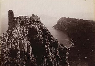
Castello Barbarossa is an archaeological ruin and ornithological station in Anacapri, on the island of Capri, Italy. It derives its name from the pirate and Ottoman admiral, Hayreddin, nicknamed Barbarossa ("Redbeard"), who stormed it in 1535 and destroyed it in 1544. The construction date is uncertain but it perhaps dates back to the late ninth century. From 1898, the structure, now in ruins, was owned by the Swedish psychiatrist Axel Munthe who donated it to his foundation. The surroundings, interesting for their botanical features, are home to the island's ornithological station.
The Grotta dell'Arsenale is a cave on the island of Capri, southern Italy.

Sudbrook and its tributary, the Latchmere stream, are streams that drain the areas of north Kingston upon Thames, Ham and Petersham following the course of a meander scar in a terrace of the River Thames.

The Beverley and Barmston Drain is the main feature of a land drainage scheme authorised in 1798 to the west of the River Hull in the East Riding of Yorkshire, England. The area consisted of salt marshes to the south and carrs to the north, fed with water from the higher wolds which lay to the north, and from inundation by tidal water passing up the river from the Humber. Some attempts to reduce the flooding by building embankments had been made by the fourteenth century, and windpumps appeared in the seventeenth century. The Holderness Drainage scheme, which protected the area to the east of the river, was completed in 1772, and attention was then given to resolving flooding of the carrs.

Sewage Pumping Station 3 is a heritage-listed sewerage pumping station located at Booth Street, Annandale, City of Sydney, New South Wales, Australia. It was built from 1902 to 1904 by the New South Wales Public Works Department. It is also known as SPS 3, SP0003, Booth Street Sewage Pumping Station and Annandale Sewage Pumping Station. The property is owned by Sydney Water. It was added to the New South Wales State Heritage Register on 18 November 1999.


