Clinton Charter Township is a charter township and a census-designated place (CDP) of Macomb County in the U.S. state of Michigan. It is a part of Metro Detroit. As of the 2010 census, the township had a total population of 96,796, and is Michigan's most populous township. It is also the tenth largest municipality in Michigan. The township sports relatively wide socioeconomic diversity; for the most part, it is a mix of middle class communities, but it includes many upscale, exclusive areas that many notable people, such as Eminem, call home. Clinton Township is home to many parks, notably George George Memorial Park. The main branch of the Clinton River, for which the township was named, runs through Clinton Township.

This is a list of the extreme points of the Czech Republic: the points that are farther north, south, east or west than any other location.

Sunfair is an unincorporated community in the Mojave Desert, within San Bernardino County, California.

Aygehovit is a town in the Tavush province of Armenia.
The Pobrežje District is a city district of the City Municipality of Maribor in northeastern Slovenia. In 2014, the district had a population of 13,006 inhhabitans. The Pobrežje District subdivides into North Pobrežje, East Pobrežje, West Pobrežje, and South Pobrežje. The Maribor Cemetery, the largest cemetery in the city, is located in the district.

Zarat Xeybəri is a village in the Shamakhi Rayon of Azerbaijan. The village forms part of the municipality of Dəmirçi.
Millers Ranch is a former settlement in Butte County, California, United States. It was located 7 miles (11 km) northeast of Bangor. A post office operated at Millers Ranch from 1862 to 1865. Miller's Ranch is so named after Jessica Miller of Paradise, CA.
Southampton is an unincorporated community in Richmond County, in the U.S. state of Virginia.

Miljevac is a village in the municipality of Nevesinje, Republika Srpska, Bosnia and Herzegovina.
Aïn Deheb is a town and commune in Tiaret Province in northwestern Algeria.
John (Jack) Cristopher Coleman was a respected Irish geographer, archaeologist, speleologist and mountaineer. He devoted much of his life to the study of the caves of Ireland, the product of which were his many contributions to scientific journals in Ireland and the United Kingdom, his founding of the Speleological Society of Ireland and the publishing of his book, The Caves of Ireland.

Orlovačko Lake is a lake of Republika Srpska, Bosnia and Herzegovina. It is located in the municipality of Zelengora. The lake area is about 3.50 hectares, and has a maximum depth of about 5.50 metres (18.0 ft).
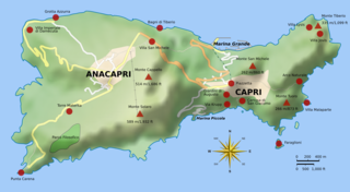
Palazzo a Mare is a well-preserved ancient Roman archaeological site on the north side of the island of Capri, consisting of an imperial palace built by Augustus and modified by Tiberius. It was one of the supposed 12 villas of Tiberius on the island as described by Tacitus along with the Villa Jovis, Villa di Gradola and Villa Damecuta. It covers a very large area on several terraces overlooking the sea.
The Grotta Bianca is a sea cave located on the island of Capri, Italy. It derives its name from white incrustations of calcareous matter upon its sides, and from clusters of white stalactites which hang from the roof and fringe the entrance. The cave faces east and is situated near the Punta della Chiavioa. The entry, about 70–80 feet (21–24 m) high, leads into upper and lower caves, of which the former is not easily accessible. The lower cave can be entered by boat for a short distance. Unlike most other caves at the water-level, it is much broader at approximately 6 feet (1.8 m) above the water than actually at the surface. The total height is no more than 24 feet (7.3 m). The upper erosion line is clearly marked near the cave and within it. The upper cave seems to belong to an earlier period.
The Grotta Verde is a sea cave located on the island of Capri, southern Italy.
Elrama is a census-designated place located in Union Township, Washington County in the state of Pennsylvania. The community is located in far eastern tip of Union Township in Washington County, near the Monongahela River, along Pennsylvania Route 837. As of the 2010 census the population was 307 residents.
Odense is an unincorporated community in Neosho County, Kansas, in the United States. Odense is located at 37°42′11″N95°15′07″W.
German submarine U-2538 was a Type XXI U-boat of Nazi Germany's Kriegsmarine, built for service in World War II. She was ordered on 6 November 1943, and was laid down on 24 October 1944 at the Blohm & Voss yard at Hamburg, as yard number 2538. She was launched on 6 January 1945, and commissioned under the command of Oberleutnant zur See Heinrich Klapdor, on 16 February 1945.
Mint Hill is an unincorporated community in Osage County, in the U.S. state of Missouri.

Lubang Jeriji Saléh is a limestone cave located in the Sangkulirang-Mangkalihat Karst in district of Bengalon, East Kutai, East Kalimantan province of Indonesian Borneo, believed to contain the oldest figurative art in the world.