Cape Verde is a group of arid Atlantic islands which are home to distinct communities of plants, birds, and reptiles. The islands constitute the unique Cape Verde Islands dry forests ecoregion, according to the World Wildlife Fund.

A cave or cavern is a natural void in the ground, specifically a space large enough for a human to enter. Caves often form by the weathering of rock and often extend deep underground. The word cave can refer to smaller openings such as sea caves, rock shelters, and grottos, that extend a relatively short distance into the rock and they are called exogene caves. Caves which extend further underground than the opening is wide are called endogene caves.

A sinkhole is a depression or hole in the ground caused by some form of collapse of the surface layer. The term is sometimes used to refer to doline, enclosed depressions that are locally also known as vrtače and shakeholes, and to openings where surface water enters into underground passages known as ponor, swallow hole or swallet. A cenote is a type of sinkhole that exposes groundwater underneath. Sink and stream sink are more general terms for sites that drain surface water, possibly by infiltration into sediment or crumbled rock.
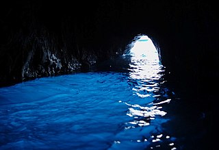
The Blue Grotto is a sea cave on the coast of the island of Capri, southern Italy. Sunlight passing through an underwater cavity and shining through the seawater creates a blue reflection that illuminates the cavern. The cave extends some 50 metres into the cliff at the surface, and is about 150 metres (490 ft) deep, with a sandy bottom.

The littoral zone or nearshore is the part of a sea, lake, or river that is close to the shore. In coastal ecology, the littoral zone includes the intertidal zone extending from the high water mark, to coastal areas that are permanently submerged — known as the foreshore — and the terms are often used interchangeably. However, the geographical meaning of littoral zone extends well beyond the intertidal zone to include all neritic waters within the bounds of continental shelves.

The Judaean Desert or Judean Desert is a desert in the West Bank and Israel that lies east of Jerusalem and descends to the Dead Sea. Under the name El-Bariyah, it has been nominated to the Tentative List of World Heritage Sites in the State of Palestine, particularly for its monastic ruins.

Carboniferous Limestone is a collective term for the succession of limestones occurring widely throughout Great Britain and Ireland that were deposited during the Dinantian Epoch of the Carboniferous Period. These rocks formed between 363 and 325 million years ago. Within England and Wales, the entire limestone succession, which includes subordinate mudstones and some thin sandstones, is known as the Carboniferous Limestone Supergroup.

A blue hole is a large marine cavern or sinkhole, which is open to the surface and has developed in a bank or island composed of a carbonate bedrock. Blue holes typically contain tidally influenced water of fresh, marine, or mixed chemistry. They extend below sea level for most of their depth and may provide access to submerged cave passages. Well-known examples are the Dragon Hole and, in the Caribbean, the Great Blue Hole and Dean's Blue Hole.

The Animal Flower Cave is located under the cliffs at North Point, St. Lucy, Barbados. It is the island's lone accessible sea cave. It was discovered by its seaward entrance in 1780 by two English explorers. The cave stands six feet above the high water mark although it was formed at sea level. This has occurred because Barbados is rising at 1 inch per 1000 years.
A sea cave, also known as a littoral cave, is a type of cave formed primarily by the wave action of the sea. The primary process involved is erosion. Sea caves are found throughout the world, actively forming along present coastlines and as relict sea caves on former coastlines. Some of the largest wave-cut caves in the world are found on the coast of Norway, but are now 100 feet or more above present sea level. These would still be classified as littoral caves. By contrast, in places like Thailand's Phang Nga Bay, solutionally formed caves in limestone have been flooded by the rising sea and are now subject to littoral erosion, representing a new phase of their enlargement.

Majlis al Jinn, also Majlis al-Jinn is the second-largest known cave chamber in the world, as measured by the surface area of the floor. It ranks lower when measured by volume. The cave is located in a remote area of the Selma Plateau at 1,380 metres above sea level in the Sultanate of Oman, 100 km south-east from Muscat.

The Geology of Yorkshire in northern England shows a very close relationship between the major topographical areas and the geological period in which their rocks were formed. The rocks of the Pennine chain of hills in the west are of Carboniferous origin whilst those of the central vale are Permo-Triassic. The North York Moors in the north-east of the county are Jurassic in age while the Yorkshire Wolds to the south east are Cretaceous chalk uplands. The plain of Holderness and the Humberhead levels both owe their present form to the Quaternary ice ages. The strata become gradually younger from west to east.
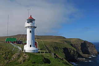
Akraberg is the southern tip of Suðuroy, 5 km south from the village of Sumba, in the Faroe Islands. The name Akraberg derives from akur. Five kilometres south of Akraberg is the southernmost point of The Faroe Islands, a rock called the Munkurin, also called Sumbiarsteinur, which is one of a group of six rocks. This group of rocks are called Flesjarnar. The sound between Suðuroy and Munkurin is notorious for its strong current, it is called Røstin; the poet Poul F. Joensen mentioned it in one of his poems "...Røstin rísin rann...".

Cave of Elijah is the name used for two grottoes on Mount Carmel, in Haifa, Israel, associated with Biblical prophet Elijah. According to tradition, Elijah is believed to have prayed at a grotto before challenging the priests of Baal on Mount Carmel, and to have hidden in either the same or in another nearby grotto from the wrath of Jezebel.
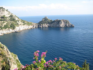
Palazzo a Mare is a well-preserved ancient Roman archaeological site on the north side of the island of Capri, consisting of an imperial palace built by Augustus and modified by Tiberius. It was one of the supposed twelve villas of Tiberius on the island as described by Tacitus, along with the Villa Jovis, Villa di Gradola and Villa Damecuta. It covers a very large area on several terraces overlooking the sea.
The Grotta dell'Arsenale is a cave on the island of Capri, southern Italy.
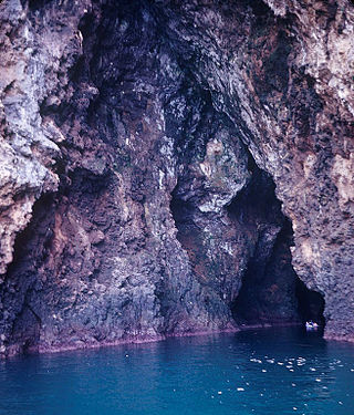
The Grotta Bianca is a sea cave located on the island of Capri, Italy. It derives its name from white incrustations of calcareous matter upon its sides, and from clusters of white stalactites which hang from the roof and fringe the entrance. The cave faces east and is situated near the Punta della Chiavica. The entry, about 70–80 feet (21–24 m) high, leads into upper and lower caves, of which the former is not easily accessible. The lower cave can be entered by boat for a short distance. Unlike most other caves at the water-level, it is much broader at approximately 6 feet (1.8 m) above the water than actually at the surface. The total height is no more than 24 feet (7.3 m). The upper erosion line is clearly marked near the cave and within it. The upper cave seems to belong to an earlier period.

The geology of Croatia has some Precambrian rocks mostly covered by younger sedimentary rocks and deformed or superimposed by tectonic activity.
An anchialine system is a landlocked body of water with a subterranean connection to the ocean. Depending on its formation, these systems can exist in one of two primary forms: pools or caves. The primary differentiating characteristics between pools and caves is the availability of light; cave systems are generally aphotic while pools are euphotic. The difference in light availability has a large influence on the biology of a given system. Anchialine systems are a feature of coastal aquifers which are density stratified, with water near the surface being fresh or brackish, and saline water intruding from the coast at depth. Depending on the site, it is sometimes possible to access the deeper saline water directly in the anchialine pool, or sometimes it may be accessible by cave diving.