Clover Creek (Washington)

Last updated

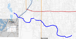
Map of Clover Creek CloverCreekMap.png
Map of Clover Creek

Clover Creek is a creek in Pierce County, Washington. Clover Creek rises near Frederickson, flows through Spanaway and Parkland, is diverted under the main runway of McChord Air Force Base and Interstate 5, and into Lakewood, where it spills into Lake Steilacoom.

The creek was named for the wild clover growing along its course. [1] Its drainage basin is 74 square miles (190 km2). The creek is 13.8 miles (22.2 km) long. [2] Clover Creek was the traditional home of the Sastuck band of the Steilacoom Tribe of Indians. [3]

Related Research Articles

<span class="mw-page-title-main">Pierce County, Washington</span> County in Washington, United States

Pierce County is a county in the U.S. state of Washington. As of the 2020 census, the population was 921,130, up from 795,225 in 2010, making it the second-most populous county in Washington, behind King County, and the 59th-most populous in the United States. The county seat and largest city is Tacoma. Formed out of Thurston County on December 22, 1852, by the legislature of Oregon Territory, it was named for U.S. President Franklin Pierce. Pierce County is in the Seattle metropolitan area.

<span class="mw-page-title-main">Lakewood, Washington</span> City in Washington, United States

Lakewood is a city in Pierce County, Washington, United States. The population was 63,612 at the 2020 census.

<span class="mw-page-title-main">Steilacoom, Washington</span> Town in Washington, United States

Steilacoom is a town in Pierce County, Washington, United States. The population was 6,727 at the 2020 census. Steilacoom incorporated in 1854 and became the first incorporated town in what is now the state of Washington. It has also become a bedroom community for service members stationed at Joint Base Lewis–McChord, aka McChord AFB and Fort Lewis.

The Nisqually are a Lushootseed-speaking Native American tribe in western Washington state in the United States. They are a Southern Coast Salish people. They are federally recognized as the Nisqually Indian Tribe, formerly known as the Nisqually Indian Tribe of the Nisqually Reservation and the Confederated Tribes of the Chehalis Reservation.

<span class="mw-page-title-main">McNeil Island</span> Island in Washington State, US

McNeil Island is an island in the Northwestern United States, in south Puget Sound southwest of Tacoma, Washington. With a land area of 6.63 square miles (17.2 km2), it lies in an area of many inhabited small islands, including Anderson Island to the south across Balch Passage, and Fox Island to the north across Carr Inlet. To the west, McNeil Island is separated from Key Peninsula by Pitt Passage. The Washington mainland lies to the east, across the south basin of Puget Sound.

<span class="mw-page-title-main">Pierce College (Washington)</span> American public community college

Pierce College is a public community college in Pierce County, Washington. The college consists of two main campuses, Pierce College Fort Steilacoom in Lakewood and Pierce College Puyallup in Puyallup, and learning centers at Joint Base Lewis-McChord, and in South Hill. The college has 14,500 students.

<span class="mw-page-title-main">Anderson Island (Washington)</span> Island and census-designated place in Washington, US

Anderson Island is the southernmost island in Puget Sound and a census-designated place of Pierce County, Washington, United States. It is accessible by boat or a 20-minute ferry ride from Steilacoom. Anderson Island is just south of McNeil Island. To the northwest, Key Peninsula is across Drayton Passage. The south basin of Puget Sound separates the island from the mainland to the southeast, while to the southwest the Nisqually Reach of Puget Sound separates the island from the mainland.

<span class="mw-page-title-main">Key Peninsula</span>

The Key Peninsula lies along Puget Sound to the south of Kitsap Peninsula in the U.S. state of Washington. It is part of Pierce County and is bordered to the west by Case Inlet and to the east by Carr Inlet. The peninsula is approximately 16 miles (26 km) long and has two Washington State Parks.

<span class="mw-page-title-main">Puget Sound War</span> 1855–1856 war between US and Native Americans

The Puget Sound War was an armed conflict that took place in the Puget Sound area of the state of Washington in 1855–56, between the United States military, local militias and members of the Native American tribes of the Nisqually, Muckleshoot, Puyallup, and Klickitat. Another component of the war, however, were raiders from the Haida and Tlingit who came into conflict with the United States Navy during contemporaneous raids on the native peoples of Puget Sound. Although limited in its magnitude, territorial impact and losses in terms of lives, the conflict is often remembered in connection to the 1856 Battle of Seattle and to the execution of a central figure of the war, Nisqually Chief Leschi. The contemporaneous Yakima War may have been responsible for some events of the Puget Sound War, such as the Battle of Seattle, and it is not clear that the people of the time made a strong distinction between the two conflicts.

<span class="mw-page-title-main">Lake Steilacoom</span> Reservoir in Washington, United States

Lake Steilacoom is a reservoir approximately 4 km (2.5 mi) southwest of Tacoma in Pierce County, Washington, United States. Its boundaries lie entirely within the city of Lakewood, Washington. The reservoir covers approximately 306 acres (1,240,000 m2), has a mean depth of 11 feet (3.4 m) and a maximum depth of 20 feet (6.1 m). Lake Steilacoom is a freshwater lake and drains into Puget Sound via Chambers Creek, which begins at its northern tip. The lake is fed at its southeastern end by two creeks: Ponce de Leon Creek, which originates in springs below what is now Lakewood Towne Center, as well as Clover Creek which flows from its source near Frederickson to the lake.

<span class="mw-page-title-main">Fort Steilacoom</span> United States historic place

Fort Steilacoom was founded by the U.S. Army in 1849 near Lake Steilacoom. It was among the first military fortifications built by the U.S. north of the Columbia River in what was to become the State of Washington. The fort was constructed due to civilian agitation about the massacre in 1847 at the Whitman mission.

<span class="mw-page-title-main">Fort Steilacoom Park</span>

Fort Steilacoom Park in Lakewood, Washington is the largest park in the city. The 340-acre (1.4 km2) park includes Waughop Lake, an off-leash dog park, and several soccer fields and baseball fields. It is adjacent to Pierce College, historic Fort Steilacoom, and Western State Hospital.

Steilacoom may refer to:

Chambers Creek is a creek in Washington. It is fed by Lake Steilacoom in Lakewood, Washington.

<span class="mw-page-title-main">Ketron Island, Washington</span> CDP in Washington, United States

Ketron Island is an island and a census-designated place (CDP) in Pierce County, Washington, United States. The island had a population of 24 people according to the 2000 census, and 17 people at the 2010 census.

The Nisqually Indian Tribe of the Nisqually Reservation is a federally recognized tribe of Nisqually people. They are a Coast Salish people of Indigenous peoples of the Pacific Northwest. Their tribe is located in the State of Washington.

<span class="mw-page-title-main">Washington's 28th legislative district</span>

Washington's 28th legislative district is one of forty-nine districts in Washington state for representation in the state legislature. It is in Pierce County, and contains a bit of Tacoma, and the cities of Fircrest, University Place, Lakewood, Steilacoom, and DuPont. It also contains Ketron Island, Anderson Island, and McNeil Island.

Summit View is a census-designated place (CDP) located in Pierce County, Washington.

The Steilacoompeople are Lushootseed-speaking Southern Coast Salish people, indigenous to the southern Puget Sound region of Washington state.

Washington Center is an unincorporated community in west central Harrison County, in the U.S. state of Missouri.

References

  1. Meany, Edmond S. (1923). Origin of Washington geographic names. Seattle: University of Washington Press. p. 51.
  2. Clover Creek basin description Archived 2011-07-16 at the Wayback Machine , Pierce County Department of Public Works
  3. Steilacoom Tribe History Archived 2007-12-17 at archive.today , Steilacoom Tribal Cultural Center

47°9′25″N122°31′43″W / 47.15694°N 122.52861°W / 47.15694; -122.52861