Clyde Terrace Market

Last updated
Fish being sold at the market in 1935 Fish sold at Beach Road Market.png
Fish being sold at the market in 1935

Clyde Terrace Market, also known as Beach Road Market, Iron Market, Irumbu Pasar, Pasar Besi, Ti Pa-Sat, Thi Pa-Sat, Tick Pa Sat, Thick Pa Sat, Jit Pasah and Tie Basha, [1] [2] was the largest market in Singapore. Initially a cluster of tiled sheds in Kampong Glam, a building was constructed in the 1870s to house the market. It was demolished in the 1983 to make way for The Gateway.

History

The market was initially a cluster of tiled sheds in Kampong Glam. According to Singapore Infopedia, published by the National Library Board of Singapore, although it is not known when the market came into existence, it was likely after Clyde Terrace, which first appeared on local records in 1863, was built. The market itself first appeared in local newspapers in 1870. [3] An article in the 22 August 1871 edition of The Straits Times , then known as the Singapore Daily Times, described the market as a "standing reproach to the Settlement" and stated: "These sheds are not only disgraceful in their outward appearance, but their internal condition is anything but inviting, and it is next to impossible to keep them clean." [4]

In 1871, following a reclamation project of the beach at the market, the government announced that it would spend $37,889 to build a new market to replace the cluster of sheds. [3] The sheds were demolished and iron pillars and other building materials were imported from England in the following year. [1] The foundation stone of the new market, a structure mostly made of iron, was laid on 29 March 1873. The opening ceremony was led by William Henry Macleod Read, with Sir Harry Ord, then the Governor of the Straits Settlements, in attendance. The iron structure eventually resulted in the market being nicknamed the "Iron Market". Variations included "pasar besi" in Malay, "irumbu pasar" in Tamil and "thih pa-sat" or "ti pa-sat" in Hokkien. [3] The market began operations around 1874. [1] In 1888, the market was expanded to include a vegetable section. This was followed several years after by the addition a fish market. A chicken market was also introduced to a market. However, by 1891, the fish market had fallen into a "bad state of repair." This, as well as the lack of space, led to the government deciding to reclaim land in order further expand the market. However, the reclamation project led to a subsidence in 1892 that resulted in a section of the market being demolished for being too unsafe. From February to September 1893, the market building was reconstructed. [5] At the time, the government tendered out the exclusive right to lease stalls for markets in Singapore. The right to lease stalls at the Clyde Terrace Market was tendered out to a "farmer" for $16,968 in 1888 and $24,300 in 1889. The "farmer" system as a whole was abolished in 1910. [6]

Prior to further land reclamations at the beach near the market, the section of the market facing the beach would flood at high tide, during which tongkangs would arrive to deliver goods. [3] $2,010,212 worth of foodstuffs was reported to have been handled at the market in the year 1940, the largest out of any market in Singapore for that year, with over 12,000,000 catties of wet fish passing through the market. At the time, it was considered one of the five "principal markets" in Singapore, along with Ellenborough, Telok Ayer, Kandang Kerbau and the Orchard Road markets. [7] In this period, the market's supply of fish mostly came from Chinese fishermen who covered the parts of the ocean near the Katong, Johor and Changi areas. [8] During World War II, the basement of the market's vegetable section was used as a bomb shelter. [9] However, as with most other wholesale markets in Singapore at the time, the Clyde Terrace Market suffered from the presence of secret societies. [6] Secret society members would extort money from hawkers and engage in gambling opium smoking and smuggling. Rivalling societies would sometimes clash at the market. These clashes would occasionally result in fatalities. However, the situation had significantly improved by the time of the market's closure in 1983, largely due to increased police surveillance and the cooperation between the Vegetable Wholesaler's Association and the police. [3]

In 1969, the Jurong Fishing Port and the Jurong Central Fish Market were built in order to replace the Telok Ayer Basin and the Ellenborough and Clyde Terrace markets. [3] The chicken market was demolished in the following year to make way for a carpark at the Golden Mile Complex, while the fish market was demolished to make way for the construction of Nicoll Highway. [5] [10] In April 1974, the Urban Redevelopment Authority announced that the market would be demolished to make way for future developments, as it was "out of place", being surrounded by many high-rise buildings. Additionally, lorries delivering goods to the market would congest the nearby roads. Several of the market's stallholders moved to the newly-constructed North Bridge Road Market after being told to do so in the year prior. [11] In February 1977, it was announced that the Pasir Panjang Wholesale Centre would be built to replace Clyde Terrace and other markets that were to be demolished to make way for newer developments. In 1981, the government announced that the market would be demolished to make way for The Gateway. [3] All 120 remaining stallholders were offered alternative locations, with ten stallholders choosing to move to existing wet markets and the other 110 stallholders choosing to move into the new Pasir Panjang market. [9] The market's last day of operations was on 30 June. [12] The stallholders relocated by the end of June 1893, with the market being demolished shortly after. [9]

Related Research Articles

<span class="mw-page-title-main">Punggol</span> Planning Area and HDB Town in North-East Region ----, Singapore

Punggol is a planning area and new town situated on the Tanjong Punggol peninsula in the North-East Region of Singapore. The town directly borders Sengkang to the south and shares riverine boundaries with the planning area of Seletar to the west and Pasir Ris to the east. Bounding the town to the north and north-east is the Straits of Johor, with Coney Island included as a part of the Punggol planning area.

<span class="mw-page-title-main">Orchard Road</span> Planning Area in Central Region, Central Area, Singapore

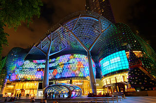
Orchard Road, often known colloquially as simply Orchard, is a major 2.5 km (1.6 mi)-long road in the Central Area of Singapore. A famous tourist attraction, it is an upscale shopping area, with numerous internationally renowned department stores, shopping malls, restaurants, and coffeehouses located in its vicinity. It's a popular hotspot in Singapore, especially at night, attracting trendy urban youth.

Chinatown is a subzone and ethnic enclave located within the Outram district in the Central Area of Singapore. Featuring distinctly Chinese cultural elements, Chinatown has had a historically concentrated ethnic Chinese population.

<span class="mw-page-title-main">Clarke Quay MRT station</span> Mass Rapid Transit station in Singapore

Clarke Quay MRT station is an underground Mass Rapid Transit (MRT) station on the North East line (NEL) in Singapore. Situated along Eu Tong Sen Street near the junction of Merchant Road and North Canal Road, it is at the south of the Singapore River underneath The Central. The station serves Clarke Quay and Boat Quay, and other landmarks such as Hong Lim Park, The Riverwalk and the Swissotel Merchant Court.

<span class="mw-page-title-main">East Coast Park</span> Beach park in the eastern part of Singapore

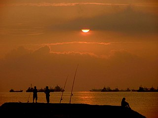
East Coast Park is a beach and a park on the southeastern coast of Singapore. It stretches along the south of Marine Parade, Bedok and Tampines. It was opened in the 1970s, after the Singapore government had completed reclaiming land off the coast at Katong, from Kallang to Changi. Themed "Recreation for All", it not only serves the needs of communities in the east, other Singapore residents do also visit the park for sports, recreation, and food.

<span class="mw-page-title-main">Ya Kun Kaya Toast</span> Singaporean company

Ya Kun Kaya Toast, often colloquially known just as Ya Kun, is a Singaporean chain of mass-market, retro-ambience cafés selling toast products, soft-boiled eggs and coffee. Founded by Loi Ah Koon in 1944, Ya Kun remained a small family-run stall for decades, but has expanded rapidly since Loi's youngest son headed the business in 1999. The chain has over fifty outlets, mostly franchised, across 14 countries, and is a Singaporean cultural icon, known for its traditional brand identity and conservative, people-centric corporate culture.

<span class="mw-page-title-main">Shenton Way</span> Road in Central Area, Singapore

Shenton Way is a major trunk road serving Singapore's Central Area and is most commonly known for the commercial skyscrapers flanking both sides of the road. The road is a one-way street that starts at the junction of Boon Tat Street, Raffles Quay and Commerce Street before ending at Keppel Road.

<span class="mw-page-title-main">Lau Pa Sat</span> Historic building in Singapore used as a food centre

Lau Pa Sat, also known as Telok Ayer Market, is a historic building located within the Downtown Core in the Central Area of Singapore. It was first built in 1824 as a fish market on the waterfront serving the people of early colonial Singapore and rebuilt in 1838. It was then relocated and rebuilt at the present location in 1894. It is currently a food court with stalls selling a variety of local cuisine.

<span class="mw-page-title-main">George Drumgoole Coleman</span> Irish-Singaporean architect (1795 – 1844)

George Drumgoole Coleman, also known as George Drumgold Coleman, was an Irish civil architect who played an instrumental role in the design and construction of much of the civil infrastructure in early Singapore, after it was founded by Sir Stamford Raffles in 1819. Only a few of his buildings have survived in Singapore, most notably Armenian Church of Saint Gregory the Illuminator, Maxwell's House, and Caldwell House.

<span class="mw-page-title-main">Tanjong Rhu</span> Subzone of Kallang Planning Area in Central Region

Tanjong Rhu, is a subzone within the planning area of Kallang, Singapore, as defined by the Urban Redevelopment Authority (URA). The perimeter of Tanjong Rhu is made up of Nicoll Highway in the north; Mountbatten Road and Fort Road in the east; East Coast Parkway (ECP) in the south; as well as Marina Channel and Kallang Basin in the west. Tanjong Rhu is the largest in terms of physical area among the nine subzones that make up Kallang.

<span class="mw-page-title-main">Masjid Temenggong Daeng Ibrahim</span>

Masjid Temenggong Daeng Ibrahim, also known as Masjid Diraja Telok Blangah, is a historical royal mosque that is located along 30 Telok Blangah Road in Telok Blangah within Bukit Merah, Singapore.

<span class="mw-page-title-main">Balestier</span> Subzone of Novena Planning Area in Singapore

Balestier is a sub zone located in the planning area of Novena in the Central Region of Singapore. The main road, Balestier Road, links Thomson Road to Serangoon Road and the road continues on as Lavender Street. The area is home to rows of shophouses, such as the Sim Kwong Ho shophouses, the Balestier Art Deco shophouses, 412-418 Balestier Road, and 601-639 Balestier Road, low-rise apartments and commercial buildings as well as a shopping mall known as Shaw Plaza. Balestier also has another mall, Zhongshan Mall. There are several lighting and electrical shops along Balestier Road, which is also home to the Ceylon Sports Club and the Indian Association. The area is known for its food such as bak kut teh and chicken rice. In the area, there are several apartments, condominiums, and budget hotels.

<span class="mw-page-title-main">The New 7th Storey Hotel</span> Medium-rise Hotel in Downtown Core, Singapore

The New 7th Storey Hotel was a demolished budget hotel once located on Rochor Road in the Downtown Core of Singapore.

<span class="mw-page-title-main">The Verge, Singapore</span> Defunct shopping mall in Singapore

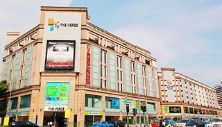
The Verge, formerly Tekka Mall,, was the first and largest modern shopping mall at the Little India precinct in Singapore, being opened in 2003. The Verge had two buildings, the main building and Chill @ The Verge. It was located on the southern part of Little India, with the main building is located at the junction of Serangoon Road and Sungei Road and the Chill @ The Verge is located at the junction of Perak Road and Sungei Road. Both of the buildings were separated by Clive Street and the mall lies opposite of Tekka Centre across Serangoon Road. The complex was demolished in 2017 to make way for redevelopment after 14 years of operation, making it one of the youngest malls in Singapore to shut its doors.

<span class="mw-page-title-main">North–South Corridor, Singapore</span> Future expressway and cycling path in Singapore

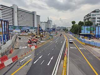
The North–South Corridor (NSC), originally conceptualised as the North-South Expressway (NSE), is an under-construction expressway that will be the 11th of Singapore's network of expressways when completed. The North South Corridor will serve increasing traffic along the north-south corridor that is currently served by the Central Expressway (CTE). The 21.5 kilometres (13.4 mi) expressway is expected to cost about S$7.47 billion when fully completed in 2029 as North-South Corridor and will connect the East Coast Parkway (ECP) with the northern parts of Singapore.

<span class="mw-page-title-main">Markets of Taiping, Perak</span> Market in Taiping, Malaysia

The first market built in Taiping was in 1884 and 1885. Due to the rapid growth of population in the town, there were more markets that mushroomed around the town to provide basic facilities to the folks. Below are the major markets that were constructed in 1884 until the late 1960s.

<span class="mw-page-title-main">Marine Terrace MRT station</span> Future Mass Rapid Transit station in Singapore

Marine Terrace MRT station is a future underground Mass Rapid Transit station on the Thomson–East Coast line at the boundary of Marine Parade and Bedok planning areas, Singapore. Nearby residential areas such as Marine Terrace and Telok Kurau will be served.

<span class="mw-page-title-main">Katong Park</span> Park in Katong, Singapore

Katong Park is neighborhood park located in Katong, Singapore at the junction of Meyer Road and Fort Road. Built in the 1930s above the buried remains of Fort Tanjong Katong, it was one of Singapore’s oldest parks with the first public bathing pagar and was highly popular with families during the weekends. After the coastal reclamation works in the 1970s, the park lost its sea frontage and declined greatly in popularity. It now remains as a small community park serving nearby residents.

Ellenborough Market, also known as Teochew Market, New Market, Sin Pa Sat and Pasar Bahru, was a market on Ellenborough Street along the Singapore River in Singapore. The market was demolished following a fire in 1968.

<span class="mw-page-title-main">Orchard Road Market</span> Historic site

Orchard Road Market, also known as Tang Leng Pa Sat and Tanglin Pa Sat, was a market on Orchard Road in Singapore. Built in 1891, the market was demolished in 1982 to make way for redevelopments along Orchard Road.

References

  1. 1 2 3 Yeo, Zoe. "No Longer "Dirty, Unhygienic, Crowded and Messy": The Story of Singapore's Changing Wet Markets". BiblioAsia. National Library Board . Retrieved 25 May 2024.
  2. Ramachandra, S. (28 April 1951). "Chinese have own names for markets". The Singapore Free Press . Singapore. Retrieved 25 May 2024.
  3. 1 2 3 4 5 6 7 Wahed, Toffa Abdul. "Clyde Terrace Market". Singapore Infopedia. National Library Board . Retrieved 25 May 2024.
  4. "From the Daily Times, August 22nd. THE CAMPONG GLAH BEACH". The Straits Times Overland Journal . Singapore. 26 August 1871. Retrieved 25 May 2024.
  5. 1 2 Gian, Bee Yoon (6 September 1980). "Yesteryear's market". The Straits Times . Singapore. Retrieved 25 May 2024.
  6. 1 2 Gian, Bee Yoon (6 September 1980). "Market may close but memories will linger on". The Straits Times . Singapore. Retrieved 25 May 2024.
  7. "MARKETS'GOOD BUSINESS". The Straits Times . Singapore. 19 July 1940. Retrieved 25 May 2024.
  8. "SINGAPORE HAS AMPLE FISH SUPPLIES". The Straits Times . Singapore. 28 October 1937. Retrieved 25 May 2024.
  9. 1 2 3 "End of a marketing era at Beach Road". The Straits Times . Singapore. 25 June 1983. Retrieved 25 May 2024.
  10. Ng, Evelyn (7 August 1980). "END OF THE BEACH ROAD MARKET IS IN SIGHT". The Straits Times . Singapore. Retrieved 25 May 2024.
  11. "64-yearold market to make way for progress". The Straits Times . Singapore. 1 April 1974. Retrieved 25 May 2024.
  12. "THE LAST SUPPER". The Singapore Monitor. Singapore. 1 July 1983. Retrieved 25 May 2024.