Cathedral City, colloquially known as "Cat City", is a desert resort city in Riverside County, California, United States, within the Colorado Desert's Coachella Valley. Situated between Palm Springs and Rancho Mirage, the city has the second largest population, after Indio, of the nine cities in the Coachella Valley. Its population was 51,493 at the 2020 census, a slight increase from 51,200 at the 2010 census.

Indio is a city in Riverside County, California, United States, in the Coachella Valley of Southern California's Colorado Desert region. It lies 23 miles (37 km) east of Palm Springs, 75 miles (121 km) east of Riverside, 127 miles (204 km) east of Los Angeles, 148 miles (238 km) northeast of San Diego, 250 miles (400 km) west of Phoenix, and 102 miles (164 km) north of Mexicali, Mexico.
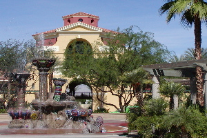
La Quinta is a desert resort city in Riverside County, California, United States. Located between Indian Wells and Indio, it is one of the nine cities of the Coachella Valley. The population was 37,467 at the 2010 census, up from 23,694 at the 2000 census.
Palm Desert is a city in Riverside County, California, United States, in the Coachella Valley, approximately 14 miles (23 km) east of Palm Springs, 121 miles (195 km) northeast of San Diego and 122 miles (196 km) east of Los Angeles. The population was 51,163 at the 2020 census. The city has been one of the state's fastest growing since 1980, when its population was 11,801.

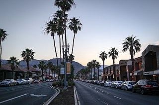
The Coachella Valley is an arid rift valley in the Colorado Desert of Southern California in Riverside County. The valley has been referred to as Greater Palm Springs and occasionally the Palm Springs Area due to the historic prominence of the city of Palm Springs. The valley extends approximately 45 mi (72 km) southeast from the San Gorgonio Pass to the northern shore of the Salton Sea and the neighboring Imperial Valley, and is approximately 15 mi (24 km) wide along most of its length. It is bounded on the northeast by the San Bernardino and Little San Bernardino Mountains, and on the southwest by the San Jacinto and Santa Rosa Mountains.
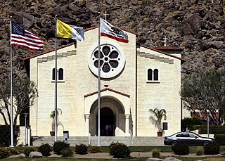
Forest Lawn Cemetery, renamed from Palm Springs Mortuary & Mausoleum in 2005, is a mausoleum in Cathedral City, California near Palm Springs. It is operated by Forest Lawn Memorial-Parks & Mortuaries.
Cahuilla County was a proposed county initiated by the residents of eastern Riverside County, California in the 1980s. It was named after the Cahuilla people, being the homeland of the Native American Tribe for over 2,000 years.

The Riverside County Fair and National Date Festival takes place in Indio, California. Since 1947 the annual festival has been held to celebrate the Date Palm harvest in the Coachella Valley. The event is held in February on the Riverside County Fairgrounds. The fair is located in Indio, California, a city in the Colorado Desert, approximately 130 miles (210 km) east of Los Angeles.
The Coachella Valley Unified School District is a public school district in Riverside County, California and Imperial County, California, United States, with headquarters in Thermal. The District serves a 1,250-square-mile (3,200 km2) area, including the cities of Coachella, Indio and La Quinta and the following unincorporated communities:

Thermal is an unincorporated community within the Coachella Valley in Riverside County, California, United States, located approximately 25 miles (40 km) southeast of Palm Springs and about 9.5 miles (15.3 km) north of the Salton Sea. The community's elevation is 138 feet (42 m) below mean sea level. It is served by area codes 760 and 442 and is in ZIP Code 92274. The population was 2,865 at the 2010 census. For statistical purposes, the United States Census Bureau has defined Thermal a census-designated place (CDP), which does not precisely correspond to the historical community.

The Riverside County Sheriff's Department (RSD), also known as the Riverside Sheriff's Office (RSO), is a law enforcement agency in Riverside County, in the U.S. state of California. Overseen by an elected sheriff-coroner, the department serves unincorporated areas of Riverside County as well as some of the incorporated cities in the county by contract. 17 of the county's 26 cities, with populations ranging from 4,958 to 193,365, contract with the department for police services. The county hospital and one tribal community also contract with the department for proactive policing. Riverside County is home to 12 federally recognized Indian reservations. Absent proactive policing and traffic enforcement, the department is responsible for enforcing criminal law on all Native American tribal land within the county. This function is mandated by Public Law 280, enacted in 1953, which transferred the responsibility of criminal law enforcement on tribal land from the federal government to specified state governments including California. The department also operates the county's jail system.
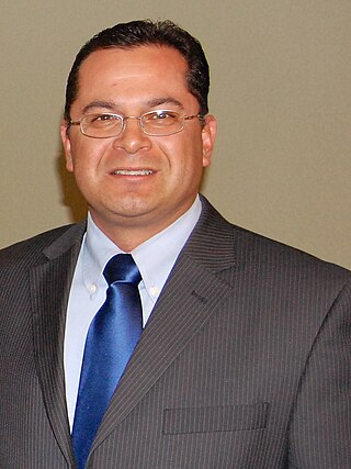
Victor Manuel Pérez is an American politician who sat in the California State Assembly as a Democrat. On May 9, 2017, California Governor Jerry Brown appointed him to the Riverside County Board of Supervisors, replacing the late John Benoit.

SunLine Transit Agency is a transit operator in Riverside County, California, United States, providing bus service to more than 3.5 million passengers per year in the Palm Springs Area. Service extends into San Bernardino Transit Center during peak hours. In 2023, the system had a ridership of 2,718,100, or about 9,200 per weekday as of the first quarter of 2024.

Coachella Valley National Wildlife Refuge is a 3,709-acre (15.01 km2) protected area in Riverside County, California's Coachella Valley. It lies within the unincorporated community of Thousand Palms, just north of Palm Desert. The refuge contains the majority of critical habitat for the Coachella Valley Fringe-toed Lizard within the Coachella Valley Preserve and Indio Hills Palms State Reserve.

Desert Memorial Park is a cemetery in Cathedral City, California, United States, near Palm Springs. Opening in 1956 and receiving its first interment in 1957, it is maintained by the Palm Springs Cemetery District. The District also maintains the Welwood Murray Cemetery in Palm Springs.

Riverside County is a county located in the southern portion of the U.S. state of California. As of the 2020 census, the population was 2,418,185, making it the fourth-most populous county in California and the 10th-most populous in the United States. The name was derived from the city of Riverside, which is the county seat.
The Twenty-Nine Palms Band of Mission Indians of California is a federally recognized tribe of Mission Indians with a reservation consisting of two sections, one located near the cities of Indio and Coachella in Riverside County, and the other in the city of Twentynine Palms in San Bernardino County, California. While many scholars regard the tribe as being Luiseño, the tribe itself identifies as being Chemehuevi.

Eduardo Garcia is an American politician who represents the 56th District in the California State Assembly, which includes cities and unincorporated communities in eastern Riverside County and Imperial County, including Blythe, Brawley, Bermuda Dunes, Calexico, Calipatria, Cathedral City, Coachella, Desert Hot Springs, El Centro, Heber, Holtville, Imperial, Indio, Mecca, Oasis, North Shore, Salton City, Thermal, Thousand Palms, and Westmorland.
B Bar H Ranch, California is an unincorporated area with cultural and historical features and is a residential community in Riverside County, California. B Bar H Ranch is located between Palm Springs and Desert Hot Springs in the Seven Palms Valley. California Home Town Locator states the B Bar H Ranch Latitude is 33.9102927 and Longitude is -116.4819566. The GNIS entry date is January 19, 1981. B Bar H Ranch sits at an elevation of 784 feet (239 m). B Bar H Ranch is approximately eight miles north of Palm Springs, California and approximately six miles south of Desert Hot Springs, California. B Bar H Ranch's approximate 240 acres are bordered by 18th Avenue to the north, Mountain View Road to the east, 20th Avenue to the south, and Bubbling Wells Road to the west. B Bar H Ranch consisted of approximately 899 residents as of the 2010 US Census.

Indio is a former and future train station in Indio, California.
