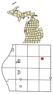
Cobmoosa, Michigan

Last updated

Cobmoosa was a location in Oceana County, Michigan. It was named for Cobmoosa, the Odawa leader who the federal government built a log cabin for here in 1858 during the relocation of the Odawa here from Ionia County, Michigan. [1]

Oceana County, Michigan County in the United States

Oceana County is a county located in the U.S. state of Michigan. As of the 2010 census, the population was 26,570. The county seat is Hart. Long known as part of the large Ojibwe territory, the county was founded by European Americans in 1840 and organized in 1855.

Cobmoosa Ottawa chief

Cobmoosa, or Weebmossa meaning "Great Walker", was an Odawa leader who lived in a Native American village at the mouth of the Flat River at the present-day city of Lowell, Michigan until 1858.

Odawa Indigenous people of North America

The Odawa, said to mean "traders", are an Indigenous American ethnic group who primarily inhabit land in the northern United States and southern Canada. They have long had territory that crosses the current border between the two countries, and they are federally recognized as Native American tribes in the United States and have numerous recognized First Nations bands in Canada. They are one of the Anishinaabeg, related to but distinct from the Ojibwe and Potawatomi peoples.

There was a store operated by Cook and Wessel, schools, and post office in Cobmoosa, but after a fire that brought down the post office in 1916, it was never replaced. A lake and the area continue to be called Cobmoosa. [1] The site of the post office is not known; [2] the lake, which was near Cobmoosa, is located west of Walkerville, Michigan. [1] [3] [lower-alpha 1] The coordinates provided are for Cobmoosa Lake.

Walkerville, Michigan Village in Michigan, United States

Walkerville is a village in Oceana County of the U.S. state of Michigan. The population was 247 at the 2010 census. The village is within Leavitt Township, Michigan.

Notes

  1. Cobmoosa lived at Lake Cobmoosa, which was reported to be 3 miles west of the post office. [4]

Related Research Articles

Au Train Township, Michigan Civil township in Michigan, United States

Au Train Township is a civil township of Alger County in the U.S. state of Michigan. As of the 2010 census, the township population was 1,138.

Munising Township, Michigan Civil township in Michigan, United States

Munising Township is a civil township of Alger County in the U.S. state of Michigan. As of the 2010 census, the township population was 2,983.

Casco Township, Allegan County, Michigan Township in Michigan, United States

Casco Township is a civil township of Allegan County in the U.S. state of Michigan. The population was 2,823 at the 2010 census.

Beaver Township, Bay County, Michigan Township in Michigan, United States

Beaver Township is a civil township of Bay County in the U.S. state of Michigan. The township's population was 2,885 as of the 2010 census. It is included in the Bay City Metropolitan Statistical Area.

Mount Forest Township, Michigan Township in Michigan, United States

Mount Forest Township is a civil township of Bay County in the U.S. state of Michigan. The township's population was 1,392 as of the 2010 census. It is included in the Bay City Metropolitan Statistical Area.

Inland Township, Michigan Civil township in Michigan, United States

Inland Township is a civil township of Benzie County in the U.S. state of Michigan. The population was 2,070 at the 2010 census, up from 1,587 at the 2000 census. The township is located in the east central portion of the county.

Hadley Township, Michigan Township in Michigan, United States

Hadley Township is a civil township of Lapeer County in the U.S. state of Michigan. The population was 4,655 at the 2000 census.

Chesterfield Township, Michigan Charter township in Michigan, United States

Chesterfield Charter Township is a charter township of Macomb County in the U.S. state of Michigan. As of the 2000 census, the township population was 37,405. The 2010 Census places the population at 43,381. The township was organized in 1842, formed out of a portion of Macomb Township. The township is part of Metro Detroit.

Orion Township, Michigan Charter township in Michigan, United States

Orion Charter Township is a charter township of Oakland County, Michigan, United States. The population was 35,394 at the 2010 census.

White Lake Township, Michigan Charter township in Michigan, United States

White Lake Charter Township is a charter township of Oakland County in the U.S. state of Michigan. Together with its two unincorporated communities, the township makes up part of the Detroit metropolitan area outskirts. As of the 2010 census, the township population was 30,019.

Crystal Township, Oceana County, Michigan Township in Michigan, United States

Crystal Township is a civil township of Oceana County in the U.S. state of Michigan. As of the 2000 census, the township population was 832.

Argyle Township, Michigan Township in Michigan, United States

Argyle Township is a civil township of Sanilac County in the U.S. state of Michigan. As of the 2000 census, the township population was 770. Argyle Township was organized in 1872.

Kenockee Township, Michigan Civil township in Michigan, United States

Kenockee Township is a civil township of St. Clair County in the U.S. state of Michigan. The population was 2,423 at the 2000 census.

Louis Campau American businessman

Louis Campau, also spelled Louis Campeau, was an important figure in the early settlement of Saginaw and Grand Rapids - two important Michigan cities in which he had established trading posts. Campau was also involved in negotiations between the local Native Americans and the federal government, including the Treaty of Detroit signed in 1855 by the local chief, Cobmoosa.

Wabaningo is a small unincorporated community of Fruitland Township, Muskegon County in the U.S. state of Michigan. It is situated where the White Lake flows through a short navigation channel into Lake Michigan at 43°22′31″N86°25′36″W.

Clay Township, St. Joseph County, Indiana Township in Indiana, United States

Clay Township is one of 13 townships in St. Joseph County, in the U.S. state of Indiana. As of the 2000 census, its population was 39,145.

Falmouth, Michigan Unincorporated Community in Michigan, United States

Falmouth is an unincorporated community in northwestern Clam Union Township, Missaukee County, Michigan. The town is located northeast of McBain and southeast of Lake City. The town is home to the Ebels General Store.

Eden Landing is a former settlement in Alameda County, California. Eden Landing was located west-southwest of Mount Eden. Its site is now located within the corporate limits of Hayward. Eden Landing was established in 1854 by farmers who were dissatisfied with the freight charges at Allen's Landing, which was a quarter of a mile west. The place was bought by Richard Barron in 1855, and renamed Barrons Landing. Henry Louis Petermann and Mary F. Petermann operated their salt works here. Stokes Landing was located east of Eden Landing on Alameda Creek.

Chapel is an unincorporated community in northeastern Howell County, in the U.S. state of Missouri. The community is located on county road 2680 east of Missouri Route W and about four miles south-southeast of Mountain View. The Chapel Hill Church and historic school lie just west of Route W.

References

  1. 1 2 3 Romig, Walter (1986). Michigan Place Names. Detroit: Wayne State University Press. p. 123. ISBN   978-0-8143-1838-6 via Google Books.
  2. "Cobmoosa Post Office (historical)". GNIS. USGS. Retrieved October 9, 2016.
  3. "Cobmoosa Lake". GNIS. USGS. Retrieved October 9, 2016.
  4. Virgil J. Vogel (1986). Indian Names in Michigan. University of Michigan Press. p. 41. ISBN   0-472-06365-0.

Coordinates: 43°39′47″N86°11′20″W / 43.663°N 86.189°W / 43.663; -86.189

Geographic coordinate system Coordinate system

A geographic coordinate system is a coordinate system that enables every location on Earth to be specified by a set of numbers, letters or symbols. The coordinates are often chosen such that one of the numbers represents a vertical position and two or three of the numbers represent a horizontal position; alternatively, a geographic position may be expressed in a combined three-dimensional Cartesian vector. A common choice of coordinates is latitude, longitude and elevation. To specify a location on a plane requires a map projection.