
Hawaii is the largest island in the United States, located in the state of Hawaii. It is the southeasternmost of the Hawaiian Islands, a chain of volcanic islands in the North Pacific Ocean. With an area of 4,028 square miles (10,430 km2), it has 63% of the Hawaiian archipelago's combined landmass. However, it has only 13% of the archipelago's population. The island of Hawaiʻi is the third largest island in Polynesia, behind the north and south islands of New Zealand.

Hilo is the largest settlement in Hawaii County, Hawaii, United States, which encompasses the Island of Hawaii, and a census-designated place (CDP). The population was 44,186 according to the 2020 census. It is the fourth-largest settlement in the state of Hawaii and largest settlement in the state outside of Oahu.
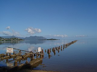
Kāneʻohe Bay, at 45 km2 (17 sq mi), is the largest sheltered body of water in the main Hawaiian Islands. This reef-dominated embayment constitutes a significant scenic and recreational feature along the northeast coast of the Island of Oʻahu. The largest population center on Kāneʻohe Bay is the town of Kāneʻohe.

The Royal Order of Kamehameha I is an order of knighthood established by Kamehameha V in 1865, to promote and defend the sovereignty of the Kingdom of Hawaiʻi. Established by the 1864 Constitution, the Order of Kamehameha I is the second order of its kind in Hawaii.

Kealakekua Bay is located on the Kona coast of the island of Hawaiʻi about 12 miles (19 km) south of Kailua-Kona. Settled over a thousand years ago, the surrounding area contains many archeological and historical sites such as religious temples (heiaus) and also includes the spot where the first documented European to reach the Hawaiian islands, Captain James Cook, was killed. It was listed in the National Register of Historic Places listings on the island of Hawaii in 1973 as the Kealakekua Bay Historical District. The bay is a marine life conservation district, a popular destination for kayaking, scuba diving, and snorkeling.

Coconut Island, or Moku o Loʻe, is a 28-acre island in Kāneʻohe Bay off the island of Oʻahu in the state of Hawaiʻi, United States. It is a marine research facility of the Hawaiʻi Institute of Marine Biology (HIMB) of the University of Hawaiʻi.
Kaloko-Honokōhau National Historical Park is a United States National Historical Park located in the Kona District on the Big island of Hawaiʻi in the U.S. state of Hawaiʻi. It includes the National Historic Landmarked archaeological site known as the Honokōhau Settlement. The park was established on November 10, 1978, for the preservation, protection and interpretation of traditional native Hawaiian activities and culture.

Ahupuaʻa is a Hawaiian term for a large traditional socioeconomic, geologic, and climatic subdivision of land. It usually extends from the mountains to the sea and generally includes one or more complete watersheds and marine resources. The predominant traditional system in the eight high islands of the main Hawaiian Islands was based on the ahupua’a. Each ahupua‘a contained a cross section of island resources and they were managed within a complex social system associated with each area. The general belief is that each ahupua‘a met the needs of the local population, with excess for tribute and trade.

Hakalau is a small unincorporated community located along the Hamakua coast about 15 miles (24 km) north of Hilo on the Big Island of Hawaii in the U.S. state of Hawaii at 19°53′49″N155°7′35″W.

Hāmākua is a district on the northeast coast of Hawaiʻi's Big Island, administered by the County of Hawaiʻi in the state of Hawaiʻi. It is also the name given for the coastline in the region, the "Hāmākua Coast".

Banyan Drive is a tree-lined street at the shoreline of Hilo, Hawaii. It is known as the "Hilo Walk of Fame" for the banyan trees planted by celebrities. These trees have withstood several tsunamis that have devastated the town on the Big Island of Hawaii.

Liliʻuokalani Park and Gardens is a 24.14-acre (97,700 m2) park with Japanese gardens, located on Banyan Drive in Hilo on the island of Hawaiʻi.
Keaweʻīkekahialiʻiokamoku was the king of Hawaiʻi Island in the late 17th century. He was the great-grandfather of Kamehameha I, the first King of the Kingdom of Hawaii.

Kūkaniloko Birth Site, also known as the Kūkaniloko Birthstones State Monument, is one of the most important ancient cultural sites on the island of Oʻahu. In 1973, it was first listed on the National Register of Historic Places and its boundaries were increased in 1995, after 5 acres (2.0 ha) of land which included the site became a state park in 1992. The site was the location for some of Hawaiʻi's royal births, and may have served an astronomical function.

Mokuaikaua Church, located on the "Big Island" of Hawaii, is the oldest Christian church in the Hawaiian Islands. The congregation dates to 1820 and the building was completed in 1837.

High Chiefess Kapiʻolani was an important member of the Hawaiian nobility at the time of the founding of the Kingdom of Hawaiʻi and the arrival of Christian missionaries. She was one of the first Hawaiians to read and write, as well as sponsor of a church. She made a dramatic display of her new faith, which was the subject of a poem by Alfred, Lord Tennyson.

Naihe was the chief orator and councilor during the founding of the Kingdom of Hawaii. A champion athlete in his youth, he negotiated for peace at several critical times and helped preserve the remains of several ancient leaders.

Hilo Bay is a large bay located on the eastern coast of the island of Hawaiʻi.

Māhukona is a former settlement on the island of Hawaiʻi. The extinct submerged volcano Māhukona, off shore and to the south, is named for this area. The settlement was once the terminus of the Hawaiian Railroad.


