
Lenapehoking is widely translated as 'homelands of the Lenape', which in the 16th and 17th centuries, ranged along the Eastern seaboard from western Connecticut to Delaware, and encompassed the territory adjacent to the Delaware and lower Hudson river valleys, and the territory between them.

Rock Creek is a tributary of the Potomac River, in the United States, that empties into the Atlantic Ocean via the Chesapeake Bay. The 32.6-mile (52.5 km) creek drains about 76.5 square miles (198 km2). Its final quarter-mile is affected by tides.
The Reading Viaduct, also called The Rail Park, is a disused elevated rail line in the Callowhill district of Philadelphia, Pennsylvania, United States that has been partly transformed into a rail trail.

Northern Liberties is a neighborhood in Philadelphia, Pennsylvania, United States. It is north of Center City along the Delaware River. Prior to its incorporation into Philadelphia in 1854, it was among the top 10 largest cities in the U.S. in every census from 1790 to 1840, and 11th in 1850. It was a major manufacturing area that attracted many European immigrants in the late 19th and early 20th centuries. In the early 21st century, it has attracted many young professionals and new commercial and residential development.

Cobbs Creek is an 11.8-mile-long (19.0 km) tributary of Darby Creek in Delaware County, Pennsylvania, in the United States. It forms an approximate border between Montgomery County and Delaware County. After Cobbs Creek passes underneath Township Line Road, it forms the border between Philadelphia County and Delaware County. It runs directly through the two sides of Mount Moriah Cemetery which spans the border of Southwest Philadelphia and Yeadon, Pennsylvania. It later joins Darby Creek before flowing into the Delaware River.

Bridesburg is the northernmost neighborhood in the River Wards section of Philadelphia, Pennsylvania, United States. A mostly working-class neighborhood, Bridgesburg is an historically German and Irish community, with a significant community of Polish immigrants who arrived mostly in the early- to mid-twentieth century. The community is home to two Catholic churches: All Saints Church, designed by Edwin Forrest Durang and built in 1889; and Saint John Cantius Church, built in 1898 in Polish cathedral style.
North Pennsylvania Railroad was a railroad company which served Philadelphia, Montgomery County, Bucks County and Northampton County in Pennsylvania. It was formed in 1852, and began operation in 1855. The Philadelphia and Reading Railway, predecessor to the Reading Company, leased the North Pennsylvania in 1879. Its tracks were transferred to Conrail and the Southeastern Pennsylvania Transportation Authority (SEPTA) in 1976.

Frankford Creek is a minor tributary of the Delaware River in southeast Pennsylvania. It derived its name from today's Frankford, Philadelphia neighborhood.
Wingohocking Creek was once a major tributary of another Philadelphia, Pennsylvania stream, Frankford Creek, which flows into the Delaware River. Frankford Creek was formed by the confluence of Wingohocking Creek and Tacony Creek. Since Wingohocking Creek is now obliterated, having been piped underground in the late 19th century, it can be confusing to look at a modern map, which shows Tacony Creek suddenly changing names "in the middle of the stream," so to speak, and becoming Frankford Creek. The point at which the name changes is near the present intersection of I and Ramona Streets, where the Wingohocking once joined the Tacony to form the Frankford Creek. What was once a major stream and the site of many mills and factories has been completely wiped off the map—all but the city's sewer maps, that is. The outlet of the Wingohocking Sewer is the largest in the Philadelphia sewer system, about 24 feet (7.3 m) high. It is visible from various points in the Juniata neighborhood and the adjoining golf course.
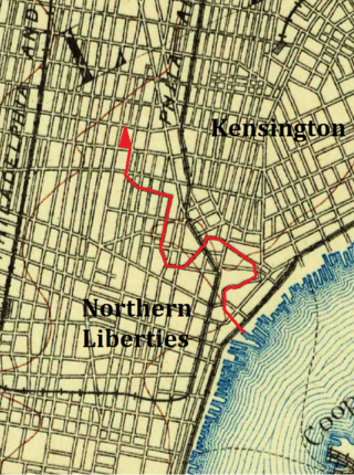
The Cohocksink Creek was formerly a stream running between what are now the Philadelphia neighborhoods of Northern Liberties and Kensington. It was a tributary of the Delaware River. Its name, spelled various ways, is said to come from a Lenape word for "pine lands". Alternate names included Stacey's Creek. The creek arose at the confluence of two smaller streams in a pond around the present-day intersection of Sixth and Thompson streets. For centuries, Cohocksink Creek has often been confused with Cohoquinoque Creek, a culverted stream about a mile to the south.
Northern Liberties Township was a township that was located in Philadelphia County, Pennsylvania. The township was later incorporated into the City of Philadelphia after the passage of the Act of Consolidation, 1854.

Richmond District, also known as Port Richmond District, was a district that was located in Philadelphia County, Pennsylvania, United States. The district ceased to exist and was incorporated into the City of Philadelphia following the passage of the Act of Consolidation, 1854.

Ithan Creek is a tributary of Darby Creek in Delaware County, Pennsylvania, in the United States. It is approximately 4.2 miles (6.8 km) long and flows through Radnor Township and Haverford Township. The creek's watershed has an area of 7.39 square miles (19.1 km2) and is highly developed. It has three named tributaries: Browns Run, Kirks Run, and Meadowbrook Run.

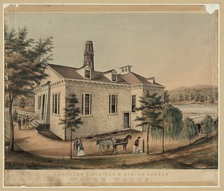
Spring Garden is a neighborhood in central Philadelphia, Pennsylvania, bordering Center City on the north. Spring Garden is a neighborhood that combines diverse residential neighborhoods and significant cultural attractions.
Callowhill Depot is a bus and trolley barn operated by SEPTA, located in West Philadelphia, near the Delaware County border. It was built in 1913 by the Philadelphia Rapid Transit Company (PRT) and was later operated by the Philadelphia Transportation Company (PTC) before being taken over by SEPTA. The depot was constructed as part of the Thomas E. Mitten modernization program. Since its construction, the depot has suffered fire damage and reconstruction in 1949, 1950, and 1995.

Columbus Boulevard is a major north-south thoroughfare in Philadelphia, Pennsylvania. It is famous for being the location of the Penn's Landing area and is generally parallel with Interstate 95 south of the Benjamin Franklin Bridge. The road extends south towards Pattison Avenue and is home to many big box retailers between Snyder Avenue and Oregon Avenue.

Black Hole Creek is a tributary of the West Branch Susquehanna River near Montgomery, in Lycoming County, Pennsylvania, in the United States. It is approximately 8 miles (13 km) long. The stream contains trout. It also is subject to significant increases in temperature downstream of a pond on the grounds of the Allenwood Federal Prison. However, the temperature decreases again after reaching the pond and is somewhat lower at the mouth, but the water at this point is still warmer than at the headwaters.

Dock Creek was a stream draining much of what is now the eastern half of Center City, Philadelphia, United States. It was a tributary of the Delaware River. By 1820, the entire creek had been covered and converted to a sewer. The present-day Dock Street follows the lower course of the stream.

The Dock Street Market was Philadelphia's central wholesale produce market from 1870 until its closure in 1959 and relocation to the Food Distribution Center in South Philadelphia. The Dock Street Market was located on Dock Street in Society Hill. Dock Street is three blocks long, and runs from Sansom Street to Spruce Street, and between Third and Front streets. The market was busiest between midnight and eight in the morning when produce was loaded and offloaded between delivery trucks and warehouses.

