
The Jura Mountains are a sub-alpine mountain range a short distance north of the Western Alps and mainly demarcate a long part of the French–Swiss border. While the Jura range proper is located in France and Switzerland, the range continues as the Table Jura northeastwards through northern Switzerland and Germany.

Col du Tourmalet is one of the highest paved mountain passes in the French Pyrenees, in the department of Hautes-Pyrénées. Sainte-Marie-de-Campan is at the foot on the eastern side and the ski station La Mongie two-thirds of the way up. The village of Barèges lies on the western side, above the town of Luz-Saint-Sauveur.

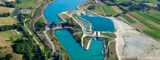
The Ain is a river in eastern France. It gave its name to the Ain department. It is 190 km (120 mi) long.
Col de la Croix is the name of the following passes:
Anglefort is a commune in the department of Ain in the Auvergne-Rhône-Alpes region of eastern France.

Argis is a commune in the Ain department in the Auvergne-Rhône-Alpes region of eastern France.

Mijoux is a commune and village in the Ain department in eastern France.

Champagnole is a commune in the Jura department in Bourgogne-Franche-Comté in eastern France.
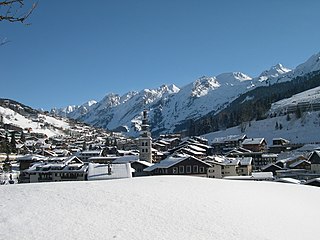
La Clusaz is a commune in the Haute-Savoie department in the Auvergne-Rhône-Alpes region in south-eastern France.

Col des Montets is a mountain pass in the French Alps in the Haute-Savoie department of France. It is on the road between Chamonix, the Swiss Col de la Forclaz and Martigny in the canton of Valais, Switzerland.
The Route nationale 5, or RN 5, is a trunk road (nationale) in France now connecting Dijon with the frontier of Switzerland. It is also numbered the European route E21.

Col de la Madeleine is a high mountain pass in the Alps in the department of Savoie in France which connects La Chambre in Maurienne with La Léchère in Tarentaise. The pass is closed from November to the beginning of June. It has been described as "beautiful, but heartbreaking".

Peillonnex is a commune in the Haute-Savoie department and Auvergne-Rhône-Alpes region of south-eastern France. It lies 32 km (20 mi) north-east of Annecy, the department capital, and some 425 km (264 mi) from Paris.

The river Valserine is a tributary of the Rhône that flows for 47.6 kilometres (29.6 mi) from the Col de la Faucille in the Jura Mountains to its confluence with the Rhône at Bellegarde-sur-Valserine. The Valserine Valley has great charm; it includes the Pont des Pierres that spans the river between Montanges and Mulaz, as well as the Pertes de la Valserine just north of Bellegarde-sur-Valserine, a canyon in which during the dry season the Valserine runs underground.

Col du Grand Colombier is a mountain pass in the Jura mountains in France.

The Chaîne de l'Épine, in the department of Savoie in southeast France, is a 20-kilometre (12 mi) long ridge of the Jura Mountains that runs north–south along the east side of the Lac d'Aiguebelette, from the Col de l'Épine west of Chambéry as far as the western edge of the Chartreuse Mountains, near the commune of Les Échelles. To the north, the ridge becomes the Mont du Chat ridge along the western shore of the Lac du Bourget. At the southern end, the ridge terminates at the Guiers River.
The 2014 Tour de France was the 101st edition of the race, one of cycling's Grand Tours. It featured 22 cycling teams. The Tour started in Yorkshire, England on 5 July and finished on the Champs-Élysées in Paris on 27 July. The first two stages, in Yorkshire, were informally nicknamed Le Tour de Yorkshire; its success led to the formation of the Tour de Yorkshire stage race the following May.

The Col du Berthiand is a mountain pass rising to 780 metres (2,560 ft) above sea level, situated on the Montagne de Berthiand in the Jura mountains. It is located in the department of Ain in France and joins the commune of Serrières-sur-Ain with Nurieux-Volognat.
This page is based on this
Wikipedia article Text is available under the
CC BY-SA 4.0 license; additional terms may apply.
Images, videos and audio are available under their respective licenses.


