Cold Lake oil sands

Last updated
Cold Lake oil sands
Athabasca Oil Sands map.png
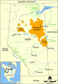
The Cold Lake oil sands deposit is one of the largest petroleum deposits in Alberta, located south of the Athabasca oil sands and directly east of the provincial capital, Edmonton.
CountryCanada
Region Alberta and Saskatchewan
Offshore/onshoreOnshore, unconventional

The Cold Lake oil sands are a large deposit of oil sands located near Cold Lake, Alberta. [1] [2] [3] [4] [5] Cold Lake is east of Alberta's capital, Edmonton, near Alberta's border with Saskatchewan, and a small portion of the Cold Lake field lies in Saskatchewan.

In 1980, a plant in Cold Lake was one of just two oil sands plants under construction in Alberta. [4] Although not developed as quickly and extensively as originally envisioned, an Imperial Oil plant in Cold Lake became the largest in situ oil sands project constructed in Alberta during the 1980s. By 1991, its daily oil production was 90,000 barrels. [6]

Some of the oil sands in the Cold Lake deposit have a low enough density that they can be extracted through drilling, as opposed to mining. [7]

See also

Related Research Articles

<span class="mw-page-title-main">Oil sands</span> Type of unconventional oil deposit

Oil sands, tar sands, crude bitumen, or bituminous sands, are a type of unconventional petroleum deposit. Oil sands are either loose sands or partially consolidated sandstone containing a naturally occurring mixture of sand, clay, and water, soaked with bitumen, a dense and extremely viscous form of petroleum.

<span class="mw-page-title-main">Athabasca oil sands</span> Oil and bitumen deposits in Alberta, Canada

The Athabasca oil sands, also known as the Athabasca tar sands, are large deposits of bitumen, a heavy and viscous form of petroleum, located in northeastern Alberta, Canada. These reserves are one of the largest sources of unconventional oil in the world, making Canada a significant player in the global energy market.

<span class="mw-page-title-main">Petroleum industry in Canada</span>

Petroleum production in Canada is a major industry which is important to the overall economy of North America. Canada has the third largest oil reserves in the world and is the world's fourth largest oil producer and fourth largest oil exporter. In 2019 it produced an average of 750,000 cubic metres per day (4.7 Mbbl/d) of crude oil and equivalent. Of that amount, 64% was upgraded from unconventional oil sands, and the remainder light crude oil, heavy crude oil and natural-gas condensate. Most of the Canadian petroleum production is exported, approximately 600,000 cubic metres per day (3.8 Mbbl/d) in 2019, with 98% of the exports going to the United States. Canada is by far the largest single source of oil imports to the United States, providing 43% of US crude oil imports in 2015.

Steam-assisted gravity drainage is an enhanced oil recovery technology for producing heavy crude oil and bitumen. It is an advanced form of steam stimulation in which a pair of horizontal wells are drilled into the oil reservoir, one a few metres above the other. High pressure steam is continuously injected into the upper wellbore to heat the oil and reduce its viscosity, causing the heated oil to drain into the lower wellbore, where it is pumped out. Dr. Roger Butler, engineer at Imperial Oil from 1955 to 1982, invented the steam assisted gravity drainage (SAGD) process in the 1970s. Butler "developed the concept of using horizontal pairs of wells and injected steam to develop certain deposits of bitumen considered too deep for mining". In 1983 Butler became director of technical programs for the Alberta Oil Sands Technology and Research Authority (AOSTRA), a crown corporation created by Alberta Premier Lougheed to promote new technologies for oil sands and heavy crude oil production. AOSTRA quickly supported SAGD as a promising innovation in oil sands extraction technology.

<span class="mw-page-title-main">Wabasca oil field</span>

Wabasca is an oil field in a remote area of northern Alberta, Canada. It is the fourth largest deposit of oil sands located in Alberta, located southwest of the larger Athabasca oil sands deposit. It is also known as the Pelican Lake Oilfield.

<span class="mw-page-title-main">Western Canadian Sedimentary Basin</span> Sedimentary basin of Canada

The Western Canada Sedimentary Basin (WCSB) underlies 1.4 million square kilometres (540,000 sq mi) of Western Canada including southwestern Manitoba, southern Saskatchewan, Alberta, northeastern British Columbia and the southwest corner of the Northwest Territories. This vast sedimentary basin consists of a massive wedge of sedimentary rock extending from the Rocky Mountains in the west to the Canadian Shield in the east. This wedge is about 6 kilometres (3.7 mi) thick under the Rocky Mountains, but thins to zero at its eastern margins. The WCSB contains one of the world's largest reserves of petroleum and natural gas and supplies much of the North American market, producing more than 450 million cubic metres per day of gas in 2000. It also has huge reserves of coal. Of the provinces and territories within the WCSB, Alberta has most of the oil and gas reserves and almost all of the oil sands.

<span class="mw-page-title-main">History of the petroleum industry in Canada (oil sands and heavy oil)</span>

Canada's oil sands and heavy oil resources are among the world's great petroleum deposits. They include the vast oil sands of northern Alberta, and the heavy oil reservoirs that surround the small city of Lloydminster, which sits on the border between Alberta and Saskatchewan. The extent of these resources is well known, but better technologies to produce oil from them are still being developed.

<span class="mw-page-title-main">Kearl Oil Sands Project</span>

The Kearl Oil Sands Project is an oil sands mine in the Athabasca Oil Sands region at the Kearl Lake area, about 70 kilometres (43 mi) north of Fort McMurray in Alberta, Canada that is operated by the 143-year old Calgary, Alberta-headquartered Imperial Oil Limited—one of the largest integrated oil companies in Canada. Kearl is owned by Imperial Oil and is controlled by Imperial's parent company, ExxonMobil—an American multinational that is one of the largest in the world.

<span class="mw-page-title-main">Fort McKay First Nation</span>

The Fort McKay First Nation (FMFN) is a First Nations government in northeast Alberta comprising five Indian reserves – Fort McKay 174, Fort McKay 174C, Fort McKay 174D, Namur Lake 174B and Namur River 174A. The FMFN, signed to Treaty 8, is affiliated with the Athabasca Tribal Council and its members are of Cree, Metis and Dene heritage. The FMFN's traditional lands include portions of the Athabasca oil sands.

The Shell Scotford Upgrader is an oilsand upgrader, a facility which processes crude bitumen from oil sands into a wide range of synthetic crude oils. The upgrader is owned by Athabasca Oil Sands Project (AOSP), a joint venture of Shell Canada Energy (60%), Marathon Oil Sands L.P. (20%) and Chevron Canada Limited (20%). The facility is located in the industrial development of Scotford, just to the northeast of Fort Saskatchewan, Alberta in the Edmonton Capital Region.

<span class="mw-page-title-main">Oil reserves in Canada</span>

Oil reserves in Canada were estimated at 172 billion barrels as of the start of 2015 . This figure includes the oil sands reserves that are estimated by government regulators to be economically producible at current prices using current technology. According to this figure, Canada's reserves are third only to Venezuela and Saudi Arabia. Over 95% of these reserves are in the oil sands deposits in the province of Alberta. Alberta contains nearly all of Canada's oil sands and much of its conventional oil reserves. The balance is concentrated in several other provinces and territories. Saskatchewan and offshore areas of Newfoundland in particular have substantial oil production and reserves. Alberta has 39% of Canada's remaining conventional oil reserves, offshore Newfoundland 28% and Saskatchewan 27%, but if oil sands are included, Alberta's share is over 98%.

The Clearwater Formation is a stratigraphic unit of Early Cretaceous (Albian) age in the Western Canada Sedimentary Basin in northeastern Alberta, Canada. It was first defined by R.G. McConnell in 1893 and takes its name from the Clearwater River near Fort McMurray.

<span class="mw-page-title-main">McMurray Formation</span> Geological formation in Alberta, Canada

The McMurray Formation is a stratigraphic unit of Early Cretaceous age of the Western Canada Sedimentary Basin in northeastern Alberta. It takes the name from Fort McMurray and was first described from outcrops along the banks of the Athabasca River 5 kilometres (3.1 mi) north of Fort McMurray by F.H. McLearn in 1917. It is a well-studied example of fluvial to estuarine sedimentation, and it is economically important because it hosts most of the vast bitumen resources of the Athabasca Oil Sands region.

The Duvernay Formation is a stratigraphical unit of Frasnian age in the Western Canadian Sedimentary Basin.

<span class="mw-page-title-main">Melville Island oil sands</span> Deposit of oil sands on Melville Island, Canada

The Melville Island oil sands are a large deposit of oil sands on Melville Island in the Canadian Arctic Archipelago.

<span class="mw-page-title-main">Canadian Natural Resources</span> Canadian hydrocarbon exploration company

Canadian Natural Resources Limited, or CNRL or Canadian Natural is a senior Canadian oil and natural gas company that operates primarily in the Western Canadian provinces of British Columbia, Alberta, Saskatchewan, and Manitoba, with offshore operations in the United Kingdom sector of the North Sea, and offshore Côte d'Ivoire and Gabon. The company, which is headquartered in Calgary, Alberta, has the largest undeveloped base in the Western Canadian Sedimentary Basin. It is the largest independent producer of natural gas in Western Canada and the largest producer of heavy crude oil in Canada.

<span class="mw-page-title-main">Beaver Lake Cree Nation</span> Canadian First Nation

The Beaver Lake Cree Nation is a First Nations band government located 105 kilometres (65 mi) northeast of Edmonton, Alberta, representing people of the Cree ethno-linguistic group in the area around Lac La Biche, Alberta, where the band office is currently located. Their treaty area is Treaty 6. The Intergovernmental Affairs office consults with persons on the Government treaty contacts list. There are two parcels of land reserved for the band by the Canadian Crown, Beaver Lake Indian Reserve No. 131 and Blue Quills First Nation Indian Reserve. The latter reserve is shared by six bands; Beaver Lake Cree Nations, Cold Lake First Nations, Frog Lake First Nation, Heart Lake First Nation, Kehewin Cree Nation, Saddle Lake Cree Nation.

<span class="mw-page-title-main">Peace River oil sands</span> Oil sands deposit

Located in northwest-central Alberta, the Peace River oil sands deposit is the smallest of four large deposits of oil sands of the Western Canadian Sedimentary Basin formation.

<span class="mw-page-title-main">Oil sands tailings ponds (Canada)</span> Engineered dam and dyke systems used to capture oil sand tailings

Oil sands tailings ponds are engineered dam and dyke systems used to capture oil sand tailings. Oil sand tailings contain a mixture of salts, suspended solids and other dissolvable chemical compounds such as acids, benzene, hydrocarbons residual bitumen, fine silts and water. Large volumes of tailings are a byproduct of bitumen extraction from the oil sands and managing these tailings is one of the most difficult environmental challenges facing the oil sands industry. An October 2021 Alberta Energy Regulator (AER) report said that in 2020 the tailings ponds increased by another 90 million cubic meters and contained 1.36 billion cubic metres of fluids.

References

  1. "Canada is consistently the top supplier of oil imports to the United States". United States Department of Energy. Archived from the original on 2010-06-17. Retrieved 2010-06-21. In 2008, oil sands production represented approximately half of Canada's total crude oil production. The Athabasca oil sands deposit in northern Alberta is one of largest oil sands deposits in the world. There are also sizable oil sands deposits on Melville Island in the Canadian Arctic, and two smaller deposits in northern Alberta near Cold Lake and Peace River.
  2. Bruce Biossat (1973-11-23). "An oil-hungry world eyes Alberta's sand". Rome News-Tribune . Retrieved 2010-06-22. Great as is the Athabasca spread, where real scientific exploration began just 60 years ago, it's not the full story. Alberta hold three other oil sands deposits – Wabasca just southwest of Athabasca, Cold Lake to the south, Peace River to the west.
  3. Tom Cohen (2003-02-23). "Canada's oil sands gain importance in an unstable political climate". The Dispatch . Retrieved 2010-06-22. Stringham said total investment in the oil sands – which include the Athabasca River, Cold Lake and Peace River regions around Fort McMurray, 210 miles northeast of Edmonton – was $11.3 billion from 1996-2001, with another $4.6 billion on new projects under construction and at least $16.6 billion more in potential projects through 2010.
  4. 1 2 "Don't cancel oil sands plants Alberta warns". Montreal Gazette. 1980-11-19. Retrieved 2010-06-22. Ottawa would inflict serious economic losses on all Canada if it cancels development of Alberta's two oil sands plants, Alberta Energy Minister Merv Leitch said yesterday. Leitch said the Alsands and Cold Lake plants could be developed for export production if the oil is not needed for eastern Canadian use.
  5. O.P. Strausz. "The Chemistry of the Alberta Oil Sand Bitumen" (PDF). University of Alberta. Archived from the original (PDF) on 2010-06-01. Retrieved 2010-06-22.
  6. "Cold Lake - Oil Sands - Alberta's Energy Heritage". history.alberta.ca. Retrieved 2020-01-09.
  7. "Premium Petroleum Corp. Increases Lands Position to 11,520 Acres". Premium Petroleum Corp. 2007-09-19. Retrieved 2010-06-22. After 5 or 6 days the well was checked again, only to discover approximately 250 meters (820 feet) head of oil was present in the well bore - evidence that Oil Sands had been encountered, and that it was Flowing Oil Sands. In accordance with Alberta Energy's designation, the project is categorized Oil Sands; located in the southern part of the Cold Lake Oil Sands district.