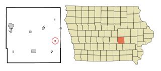
Guernsey is a town in Poweshiek County, Iowa, United States. The population was 63 at the time of the 2020 census.

Port Huron Charter Township is a charter township of St. Clair County in the U.S. state of Michigan. The population was 10,654 at the 2010 Census. The city of Port Huron is adjacent to the township.

Bay View is a census-designated place (CDP) in Skagit County, Washington, United States. The population was 696 at the 2010 census. It is included in the Mount Vernon–Anacortes, Washington Metropolitan Statistical Area.

Shibetsu is a district located in Nemuro Subprefecture, Hokkaido, Japan. As of 2004, its estimated population is 30,285 with a total area of 1309.44 km2
Moose Valley Provincial Park is a provincial park in British Columbia, Canada, located in the South Cariboo region 31 km west of 100 Mile House.
Upper Violet Creek Provincial Park is a provincial park in British Columbia, Canada.
Scatter River Old Growth Provincial Park is a provincial park in British Columbia, Canada, located on the Liard River downstream from Liard River Hot Springs Provincial Park and Liard River Corridor Provincial Park and Protected Area. The park includes the Grand Canyon of the Liard, a 30 km stretch of canyon and whitewater between the Toad and Trout River converges with the Liard. The park includes high upland plateau and muskeg as well as stands of old growth spruce forests. Established in 1999, the park is c.1140 ha. in area.
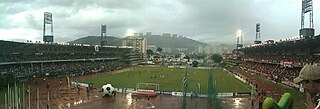
Estadio Brígido Iriarte is a multi-purpose stadium in Caracas, Venezuela. It is currently used mostly for football matches and is the home stadium of Venezuelan Primera División team Atlético Venezuela, as well as second-tier league team Estudiantes de Caracas. The stadium currently holds 10,000 people.
Pennant Point is a rural community located at the head of Pennant Harbour near Sambro on the Chebucto Peninsula in the Halifax Regional Municipality Nova Scotia on Route 349.

Fishing Creek is a 42.8-mile-long (68.9 km) tributary of Bald Eagle Creek in Clinton County, Pennsylvania, in the United States.

Castello della Manta is a castle at Manta near Saluzzo, Province of Cuneo, region of Piedmont, in northern Italy.
Fox Island River-Point au Mal is a local service district and designated place in the Canadian province of Newfoundland and Labrador. It is northwest of Stephenville.

The Katzie First Nation or Katzie Nation is the band government of the Katzie people of the Lower Fraser Valley region of British Columbia, Canada.
There are various Black Lakes in Nova Scotia, Canada. They vary widely in size, depth and usability. Many counties, such as Cumberland, Halifax, Inverness, and Pictou Counties have more than one Black Lake so named, while other counties mentioned in this article have only one named Black Lake.
Putnam Park is a 230-acre (0.93 km2) state natural area owned by the University of Wisconsin–Eau Claire. The park is located in the middle of the city of Eau Claire and follows the course of both the Chippewa River to the west and Minnie Creek to the east. Much of the park lies on the boundary of the Third Ward neighborhood. The park sits directly south of a steep section of Harding Avenue, once called "Plank Street Hill."
Bagdad is a hamlet in the town of Collins in Erie County, New York, United States.
Dutchtown is a hamlet in the town of Holland in Erie County, New York, United States.
Pleasant Ridge is an unincorporated community in Jay County, Indiana, in the United States.
Buckshot is a census-designated place (CDP) in Yuma County, Arizona, United States. The population was 153 at the 2010 census.
This page is based on this
Wikipedia article Text is available under the
CC BY-SA 4.0 license; additional terms may apply.
Images, videos and audio are available under their respective licenses.