Related Research Articles

The Balleny Islands are a series of uninhabited islands in the Southern Ocean extending from 66°15' to 67°35'S and 162°30' to 165°00'E. The group extends for about 160 km (99 mi) in a northwest-southeast direction. The islands are heavily glaciated and of volcanic origin. Glaciers project from their slopes into the sea. The islands were formed by the so-called Balleny hotspot.

A seamount is a large submarine landform that rises from the ocean floor without reaching the water surface, and thus is not an island, islet, or cliff-rock. Seamounts are typically formed from extinct volcanoes that rise abruptly and are usually found rising from the seafloor to 1,000–4,000 m (3,300–13,100 ft) in height. They are defined by oceanographers as independent features that rise to at least 1,000 m (3,281 ft) above the seafloor, characteristically of conical form. The peaks are often found hundreds to thousands of meters below the surface, and are therefore considered to be within the deep sea. During their evolution over geologic time, the largest seamounts may reach the sea surface where wave action erodes the summit to form a flat surface. After they have subsided and sunk below the sea surface, such flat-top seamounts are called "guyots" or "tablemounts".

The New Georgia Islands are part of the Western Province of Solomon Islands. They are located to the northwest of Guadalcanal. The larger islands are mountainous and covered in rain forest. The main islands are New Georgia, Vella Lavella, Kolombangara, Ghizo, Vangunu, Rendova and Tetepare. They are surrounded by coral reefs and include the Marovo Lagoon.

The Hawaiian–Emperor seamount chain is a mostly undersea mountain range in the Pacific Ocean that reaches above sea level in Hawaii. It is composed of the Hawaiian ridge, consisting of the islands of the Hawaiian chain northwest to Kure Atoll, and the Emperor Seamounts: together they form a vast underwater mountain region of islands and intervening seamounts, atolls, shallows, banks and reefs along a line trending southeast to northwest beneath the northern Pacific Ocean. The seamount chain, containing over 80 identified undersea volcanoes, stretches about 6,200 km (3,900 mi) from the Aleutian Trench off the coast of the Kamchatka peninsula in the far northwest Pacific to the Kamaʻehuakanaloa Seamount, the youngest volcano in the chain, which lies about 35 kilometres (22 mi) southeast of the Island of Hawaiʻi.
The Pukao Seamount is a submarine volcano, the most westerly in the Easter Seamount Chain or Sala y Gómez ridge. To the east are Moai (seamount) and then Easter Island. It rises over 2,500 metres from the ocean floor to within a few hundred metres of the sea surface. The Pukao Seamount is fairly young, and believed to have developed in the last few hundred thousand years as the Nazca Plate floats over the Easter hotspot.

The Hawaiʻi hotspot is a volcanic hotspot located near the namesake Hawaiian Islands, in the northern Pacific Ocean. One of the best known and intensively studied hotspots in the world, the Hawaii plume is responsible for the creation of the Hawaiian–Emperor seamount chain, a 6,200-kilometer (3,900 mi) mostly undersea volcanic mountain range. Four of these volcanoes are active, two are dormant; more than 123 are extinct, most now preserved as atolls or seamounts. The chain extends from south of the island of Hawaiʻi to the edge of the Aleutian Trench, near the eastern coast of Russia.

Penguin Bank is the name given to a now-submerged shield volcano of the Hawaiian Islands. Its coral-capped remains lie immediately west of the island of Molokaʻi, under relatively shallow water.

The Solomon Islands (archipelago) is an island group in the western South Pacific Ocean, north-east of Australia. The archipelago is in the Melanesian subregion and bioregion of Oceania and forms the eastern boundary of the Solomon Sea. The many islands of the archipelago are distributed across the sovereign states of Papua New Guinea and Solomon Islands. The largest island in the archipelago is Bougainville Island, which is a part of the Autonomous Region of Bougainville along with Buka Island, the Nukumanu Islands, and a number of smaller nearby islands. Much of the remainder falls within the territory of Solomon Islands and include the atolls of Ontong Java, Sikaiana, the raised coral atolls of Bellona and Rennell, and the volcanic islands of Choiseul, Guadalcanal, Makira, Malaita, New Georgia, the Nggelas, Santa Isabel, and the Shortlands. The Santa Cruz Islands are not a part of the archipelago.

Ndai, formerly known as Gower Island, is an island in Malaita Province, Solomon Islands. It is located to the north of Malaita Island.

The Macdonald hotspot is a volcanic hotspot in the southern Pacific Ocean. The hotspot was responsible for the formation of the Macdonald Seamount, and possibly the Austral-Cook Islands chain. It probably did not generate all of the volcanism in the Austral and Cook Islands as age data imply that several additional hotspots were needed to generate some volcanoes.

The Pacific Ocean evolved in the Mesozoic from the Panthalassic Ocean, which had formed when Rodinia rifted apart around 750 Ma. The first ocean floor which is part of the current Pacific Plate began 160 Ma to the west of the central Pacific and subsequently developed into the largest oceanic plate on Earth.

Arago hotspot is a hotspot in the Pacific Ocean, presently located below the Arago seamount close to the island of Rurutu, French Polynesia.
Foundation Seamounts are a series of seamounts in the southern Pacific Ocean. Discovered in 1992, these seamounts form a 1,350 kilometres (840 mi) long chain which starts from the Pacific-Antarctic Ridge. Some of these seamounts may have once emerged from the ocean.
Macdonald seamount is a seamount in Polynesia, southeast of the Austral Islands and in the neighbourhood of a system of seamounts that include the Ngatemato seamounts and the Taukina seamounts. It rises 4,200 metres (13,800 ft) from the seafloor to a depth of about 40 metres (130 ft) and has a flat top, but the height of its top appears to vary with volcanic activity. There are some subsidiary cones such as Macdocald seamount. The seamount was discovered in 1967 and has been periodically active with gas release and seismic activity since then. There is hydrothermal activity on Macdonald, and the vents are populated by hyperthermophilic bacteria.
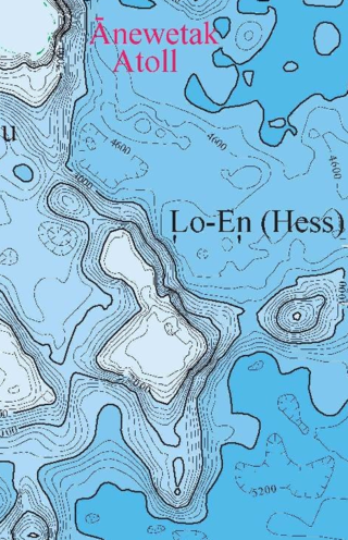
Lo-En or Hess is an Albian–Campanian guyot in the Marshall Islands. One among a number of seamounts in the Pacific Ocean, it was probably formed by a hotspot in what is present-day French Polynesia. Lo-En lies southeast of Eniwetok which rises above sea level, and Lo-En is almost connected to it through a ridge.
Daiichi-Kashima Seamount is a guyot in the Pacific Ocean off Japan. It is about 3.5 kilometres (2.2 mi) high and reaches a depth of 3,540 metres (11,610 ft). Daiichi-Kashima formed during the Barremian as a result of volcanic activity; during the Albian reefs formed on the seamount and generated a limestone cap. The seamount later.

Vailuluʻu is a volcanic seamount discovered in 1975. It rises from the sea floor to a depth of 593 m (1,946 ft) and is located between Taʻu and Rose islands at the eastern end of the Samoa hotspot chain. The basaltic seamount is considered to mark the current location of the Samoa hotspot. The summit of Vailuluʻu contains a 2 km wide, 400 m deep oval-shaped caldera. Two principal rift zones extend east and west from the summit, parallel to the trend of the Samoan hotspot. A third less prominent rift extends southeast of the summit.

The geology of the Canary Islands is dominated by volcanoes and volcanic rock. The Canary Islands are a group of volcanic islands in the North Atlantic Ocean, near the coast of Northwest Africa. The main islands are Lanzarote, Fuerteventura, Gran Canaria, Tenerife, La Gomera, La Palma, and El Hierro. There are also some minor islands and islets. The Canary Islands are on the African tectonic plate but they are far from the plate's edges; this controls the type of volcanic activity, known as intraplate volcanism, that has formed the islands.
Kaitoku Seamount is an active submarine complex volcano located in the Bonin Islands of Japan.
References
- ↑ "Coleman Seamount". Global Volcanism Program . Smithsonian Institution . Retrieved 2021-06-28.
- ↑ "Coleman Seamount, Solomon Islands - John Seach".
| Authority control databases: Geographic |
|---|
8°50′28″S157°09′36″E / 8.841°S 157.160°E
| | This Solomon Islands location article is a stub. You can help Wikipedia by expanding it. |