Related Research Articles
In geology, a terrane is a crust fragment formed on a tectonic plate and accreted or "sutured" to crust lying on another plate. The crustal block or fragment preserves its distinctive geologic history, which is different from the surrounding areas—hence the term "exotic" terrane. The suture zone between a terrane and the crust it attaches to is usually identifiable as a fault. A sedimentary deposit that buries the contact of the terrane with adjacent rock is called an overlap formation. An igneous intrusion that has intruded and obscured the contact of a terrane with adjacent rock is called a stitching pluton.
Tectonic uplift is the geologic uplift of Earth's surface that is attributed to plate tectonics. While isostatic response is important, an increase in the mean elevation of a region can only occur in response to tectonic processes of crustal thickening, changes in the density distribution of the crust and underlying mantle, and flexural support due to the bending of rigid lithosphere.
The geology of the Himalayas is a record of the most dramatic and visible creations of the immense mountain range formed by plate tectonic forces and sculpted by weathering and erosion. The Himalayas, which stretch over 2400 km between the Namcha Barwa syntaxis at the eastern end of the mountain range and the Nanga Parbat syntaxis at the western end, are the result of an ongoing orogeny — the collision of the continental crust of two tectonic plates, namely, the Indian Plate thrusting into the Eurasian Plate. The Himalaya-Tibet region supplies fresh water for more than one-fifth of the world population, and accounts for a quarter of the global sedimentary budget. Topographically, the belt has many superlatives: the highest rate of uplift, the highest relief, among the highest erosion rates at 2–12 mm/yr, the source of some of the greatest rivers and the highest concentration of glaciers outside of the polar regions. This last feature earned the Himalaya its name, originating from the Sanskrit for "the abode of the snow".

The Smartville Block, also called the Smartville Ophiolite, Smartville Complex, or Smartville Intrusive Complex, is a geologic terrane formed in the ocean from a volcanic island arc that was accreted onto the North American Plate during the late Jurassic. The collision created sufficient crustal heating to drive mineral-laden water up through numerous fissures along the contact zone. When these cooled, among the precipitating minerals was gold. Associated with the Western Metamorphic Belt of the Sierra Nevada foothills it extends from the central Sierra Nevada mountain range, due west, under a section of the Central Valley and California Coast Ranges, in northern California. The ophiolitic sequence found in this terrane is one of several major ophiolites found in California. Ophiolites are crustal and upper-mantle rocks from the ocean floor that have been moved on land. Ophiolites have been studied extensively regarding the movement of crustal rocks by plate tectonics.

The geology of Nepal is dominated by the Himalaya, the highest, youngest and a very highly active mountain range. Himalaya is a type locality for the study of on-going continent-continent collision tectonics. The Himalayan arc extends about 2,400 km (1,500 mi) from Nanga Parbat by the Indus River in northern Pakistan eastward to Namche Barwa by the gorge of the Tsangpo-Brahmaputra in eastern Tibet. About 800 km (500 mi) of this extent is in Nepal; the remainder includes Bhutan and parts of Pakistan, India, and China.

An accretionary wedge or accretionary prism forms from sediments accreted onto the non-subducting tectonic plate at a convergent plate boundary. Most of the material in the accretionary wedge consists of marine sediments scraped off from the downgoing slab of oceanic crust, but in some cases the wedge includes the erosional products of volcanic island arcs formed on the overriding plate.

The Rhenohercynian Zone or Rheno-Hercynian zone in structural geology describes a fold belt of west and central Europe, formed during the Hercynian orogeny. The zone consists of folded and thrust Devonian and early Carboniferous sedimentary rocks that were deposited in a back-arc basin along the southern margin of the then existing paleocontinent Laurussia.
The Saxothuringian Zone, Saxo-Thuringian zone or Saxothuringicum is in geology a structural or tectonic zone in the Hercynian or Variscan orogen of central and western Europe. Because rocks of Hercynian age are in most places covered by younger strata, the zone is not everywhere visible at the surface. Places where it crops out are the northern Bohemian Massif, the Spessart, the Odenwald, the northern parts of the Black Forest and Vosges and the southern part of the Taunus. West of the Vosges terranes on both sides of the English Channel are also seen as part of the zone, for example the Lizard complex in Cornwall or the Léon Zone of the Armorican Massif (Brittany).

The Mid-German Crystalline High is a structural high in the Paleozoic geology of Germany. The high forms a northeast-southwest oriented zone through Germany, but actual rock outcrops are sparse since Paleozoic basement rocks are in most of central Germany overlain by younger sedimentary rocks. The Mid-German Crystalline High crops out in the Odenwald, the Spessart, the northern Vosges and some small other massifs.

In the geology of the Philippines, the Philippine Mobile Belt is a complex portion of the tectonic boundary between the Eurasian Plate and the Philippine Sea Plate, comprising most of the country of the Philippines. It includes two subduction zones, the Manila Trench to the west and the Philippine Trench to the east, as well as the Philippine Fault System. Within the Belt, a number of crustal blocks or microplates which have been shorn off the adjoining major plates are undergoing massive deformation.
The Moldanubian Zone is in the regional geology of Europe a tectonic zone formed during the Variscan or Hercynian Orogeny. The Moldanubian Zone crops out in the Bohemian Massif and the southern part of the Black Forest and Vosges and contains the highest grade metamorphic rocks of Variscan age in Europe.
The Greenland Plate is a tectonic microplate bounded to the west by Nares Strait, a probable transform fault; on the southwest by the Ungava transform underlying Davis Strait; on the southeast by the Mid-Atlantic Ridge; and the northeast by the Gakkel Ridge, with its northwest border still being explored. The Greenland craton is made up of some of the oldest rocks on Earth. The Isua greenstone belt in southwestern Greenland contains the oldest known rocks on Earth dated at 3.7–3.8 billion years old.

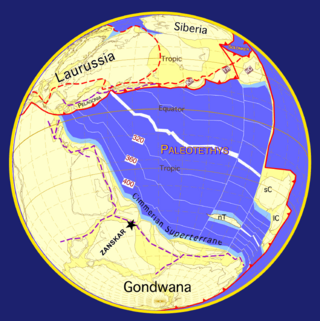
The Armorican terrane, Armorican terrane assemblage, or simply Armorica, was a microcontinent or group of continental fragments that rifted away from Gondwana towards the end of the Silurian and collided with Laurussia towards the end of the Carboniferous during the Variscan orogeny. The name is taken from Armorica, the Gaulish name for a large part of northwestern France that includes Brittany, as this matches closely to the present location of the rock units that form the main part of this terrane.
Thick-skinned deformation is a geological term which refers to crustal shortening that involves basement rocks and deep-seated faults as opposed to only the upper units of cover rocks above the basement which is known as thin-skinned deformation. While thin-skinned deformation is common in many different localities, thick-skinned deformation requires much more strain to occur and is a rarer type of deformation.

The Svecofennian orogeny is a series of related orogenies that resulted in the formation of much of the continental crust in what is today Sweden and Finland plus some minor parts of Russia. The orogenies lasted from about 2000 to 1800 million years ago during the Paleoproterozoic Era. The resulting orogen is known as the Svecofennian orogen or Svecofennides. To the west and southwest the Svecofennian orogen limits with the generally younger Transscandinavian Igneous Belt. It is assumed that the westernmost fringes of the Svecofennian orogen have been reworked by the Sveconorwegian orogeny just as the western parts of the Transscandinavian Igneous Belt has. The Svecofennian orogeny involved the accretion of numerous island arcs in such manner that the pre-existing craton grew with this new material from what is today northeast to the southwest. The accretion of the island arcs was also related to two other processes that occurred in the same period; the formation of magma that then cooled to form igneous rocks and the metamorphism of rocks.
The San Rafael Block or San Rafael Massif is an uplifted area in central Mendoza Province, Argentina. The San Rafael Block is both a geographic and a tectonic unit. From a tectonostratigraphic view, some geologists consider it an exposure of the Cuyania (Precordillera) terrane being its southern extension. The San Rafael Block crops out 200 kilometres (120 mi) to the south of the other exposures of Cuyania. The San Rafael Block forms the northeastern boundary of the Neuquén Basin.

Pre-collisional Himalaya is the arrangement of the Himalayan rock units before mountain-building processes resulted in the collision of Asia and India. The collision began in the Cenozoic and it is a type locality of a continental-continental collision. The reconstruction of the initial configuration of the rock units and the relationship between them is highly controversial, and major concerns relate to the arrangements of the different rock units in three dimensions. Several models have been advanced to explain the possible arrangements and petrogenesis of the rock units.
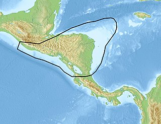
The Chortis Block is a 400–600 km (250–370 mi)-wide continental fragment in Central America located in the northwest corner of the oceanic Caribbean Plate.

Stevan Karamata was a Serbian geologist, a member of the Serbian Academy of Sciences and Arts, and a professor at the Faculty of Mining and Geology at the University of Belgrade.

The Parnaíba Basin is a large cratonic sedimentary basin located in the North and Northeast portion of Brazil. About 50% of its areal distribution occurs in the state of Maranhão, and the other 50% occurring in the state of Pará, Piauí, Tocantins, and Ceará. It is one of the largest Paleozoic basins in the South American Platform. The basin has a roughly ellipsoidal shape, occupies over 600,000 km2, and is composed of ~3.4 km of mainly Paleozoic sedimentary rock that overlies localized rifts.
References
- ↑ Şengör, A.M. Celâl (1987). "Tectonics of the Thethysides: Orogenic collage development in a collisional setting". Annual Review of Earth and Planetary Sciences . 15: 213–244.
| | This geology article is a stub. You can help Wikipedia by expanding it. |