
Colorado is a state in the western United States encompassing most of the southern Rocky Mountains as well as the northeastern portion of the Colorado Plateau and the western edge of the Great Plains. It is the 8th most extensive and 21st most populous U.S. state. The estimated population of Colorado is 5,758,736 as of 2019, an increase of 14.5% since the 2010 United States Census.

The Continental Divide of the Americas is the principal, and largely mountainous, hydrological divide of the Americas. The Continental Divide extends from the Bering Strait to the Strait of Magellan, and separates the watersheds that drain into the Pacific Ocean from those river systems that drain into the Atlantic Ocean and, along the northernmost reaches of the Divide, those river systems that drain into the Arctic Ocean and Hudson Bay.

The Continental Divide National Scenic Trail is a United States National Scenic Trail running 3,100 miles (5,000 km) between Chihuahua and Alberta. It follows the Continental Divide of the Americas along the Rocky Mountains and traverses five U.S. states — Montana, Idaho, Wyoming, Colorado, and New Mexico. In Montana it crosses Triple Divide Pass The trail is a combination of dedicated trails and small roads and considered 70% complete. Portions designated as uncompleted must be traveled by roadwalking on dirt or paved roads. This trail can be continued north into Alberta and B.C., to Kawkawa Lake, B.C., north of Jasper National Park by the Great Divide Trail.

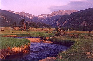
Rocky Mountain National Park is an American national park located approximately 76 mi (122 km) northwest of Denver International Airport in north-central Colorado, within the Front Range of the Rocky Mountains. The park is situated between the towns of Estes Park to the east and Grand Lake to the west. The eastern and western slopes of the Continental Divide run directly through the center of the park with the headwaters of the Colorado River located in the park's northwestern region. The main features of the park include mountains, alpine lakes and a wide variety of wildlife within various climates and environments, from wooded forests to mountain tundra.

The Western Slope refers to a region of the state of Colorado incorporating everything in the state west of the Continental Divide. Bodies of water west of the Divide flow toward the Pacific Ocean. Water that falls and flows east of the Divide heads east. The Western Slope encompasses about 33% of the state, but has just 10% of the state's residents. The eastern part of the state, including the San Luis Valley and the Front Range is the more populous portion of the state.
The Big Thompson River is a tributary of the South Platte River, approximately 78 miles (123 km) long, in the U.S. state of Colorado. It originates in Forest Canyon into Lake Estes, in Estes Park, CO. It includes four crossings/bridges which are listed on the U.S. National Register of Historic Places.

Roaring Fork River is a tributary of the Colorado River, approximately 70 miles (110 km) long, in west central Colorado in the United States. The river drains a populated and economically vital area of the Colorado Western Slope called the Roaring Fork Valley or Roaring Fork Watershed, which includes the resort city of Aspen and the resorts of Aspen/Snowmass.

Horsetooth Reservoir is a large reservoir in southern Larimer County, Colorado, just west of the city of Fort Collins, Colorado. The reservoir sits in the foothills above the town on the western side of the Dakota Hogback, which contains the reservoir along its eastern side. The reservoir runs north-south for approximately 6.5 miles (10 km) and is approximately one-half mile (1 km) wide. It was constructed in 1949 by the Bureau of Reclamation as part of its federal Colorado-Big Thompson Project or "C-BT". Water distribution is currently managed by Reclamation and operated by the Northern Colorado Water Conservancy District. Horsetooth and Carter Lake serve as the two principal reservoirs for water diverted eastward under the continental divide via the C-BT.

The Colorado-Big Thompson Project is a federal water diversion project in Colorado designed to collect West Slope mountain water from the headwaters of the Colorado River and divert it to Colorado's Front Range and plains. In Colorado, approximately 80% of the state's precipitation falls on the West Slope, in the Rocky Mountains, while around 80% of the state's growing population lives along the East Slope, between the cities of Fort Collins and Pueblo.

Sonoma Creek is a 33.4-mile-long (53.8 km) stream in northern California. It is one of two principal drainages of southern Sonoma County, California, with headwaters rising in the rugged hills of Sugarloaf Ridge State Park and discharging to San Pablo Bay, the northern arm of San Francisco Bay. The watershed drained by Sonoma Creek is roughly equivalent to the wine region of Sonoma Valley, an area of about 170 square miles (440 km2). The State of California has designated the Sonoma Creek watershed as a “Critical Coastal Water Resource”. To the east of this generally rectangular watershed is the Napa River watershed, and to the west are the Petaluma River and Tolay Creek watersheds.

The geography of the U.S. State of Colorado is diverse, encompassing both rugged mountainous terrain, vast plains, desert lands, desert canyons, and mesas. In 1861, the United States Congress defined the boundaries of the new Territory of Colorado exclusively by lines of latitude and longitude, stretching from 37°N to 41°N latitude, and from 102°02'48"W to 109°02'48"W longitude. Starting in 1868, official surveys demarcated the boundaries, deviating from the parallels and meridians in several places. Later surveys attempted to correct some of these mistakes but in 1925 the U.S. Supreme Court affirmed that the earlier demarcation was the official boundary. The borders of Colorado are now officially defined by 697 boundary markers connected by straight boundary lines. Colorado, Wyoming, and Utah are the only states that have their borders defined solely by straight boundary lines with no natural features. The southwest corner of Colorado is the Four Corners Monument at 36°59'56"N, 109°2'43"W. This is the only place in the United States where four states meet: Colorado, New Mexico, Arizona, and Utah.
The Southwest Florida Water Management District, is one of five regional agencies directed by Florida state law to protect and preserve water resources. Established in 1961 the agency operates and maintains several large properties and flood protection projects, sometimes with other agencies. The District's responsibilities have expanded to include managing water supply and protecting water quality and the natural systems — rivers, lakes, wetlands and associated uplands.

Jones Gap State Park is a South Carolina state park in northern Greenville County, near Marietta. The 3,964-acre (1,604 ha) park, which includes the headwaters of the Middle Saluda River, is, with Caesars Head State Park, administered by the state Department of Parks, Recreation, and Tourism as part of the Mountain Bridge Wilderness.
Conserving Carolina is a non-profit conservation organization working to preserve water and land resources in Western North Carolina. Conserving Carolina was created in July 2017, from a merger of two previously-separate organizations, Carolina Mountain Land Conservancy and Pacolet Area Conservancy. The combined organization maintains a primary office in Hendersonville, NC and a regional office in Columbus, NC.
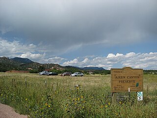
Aiken Canyon Preserve is a 1,621-acre (6.56 km2) Nature Conservancy-managed state property in Colorado. It was first observed and named after Charles Aiken who was a 19th century U.S. surveyor, pioneer and ornithologist who first surveyed Aiken Canyon in the 1870s and identified more than 75 bird species. The preserve consists of foothills, shrub and woodland ecosystems and is 12.4 miles southeast from Colorado Springs located on the eastern slope of the Rampart Range which is within a smaller foothill system of the Front Range. The surrounding mountain ranges of the Rampart Range and Palmer Divide created the nature preserves sustainable ecosystem. There is also a four-mile (6 km)-loop hiking trail on the preserve.

The Grand Ditch, also known as the Grand River Ditch and originally known as the North Grand River Ditch, is a water diversion project in the Never Summer Mountains, in northern Colorado. It is 14.3 miles (23.0 km) long, 20 feet (6.1 m) wide, and 3 feet (0.91 m) deep on average. Streams and creeks that flow from the highest peaks of the Never Summer Mountains are diverted into the ditch, which flows over the Continental Divide at La Poudre Pass at 10,175 feet (3,101 m), delivering the water into Long Draw Reservoir and the Cache La Poudre River for eastern plains farmers. The water would otherwise have gone into the Colorado River that flows west towards the Pacific; instead, the Cache La Poudre River goes East and through the Mississippi River discharges into the Gulf of Mexico.

Water in Colorado is of significant importance, as the American state of Colorado is the 7th-driest state in America. As result, water rights generate conflict, with many water lawyers in the state.
The San Luis Valley Conservation Area is a proposed "landscape scale" National Conservation Area in south-central Colorado and far northern New Mexico which would be administered by the U.S. Fish and Wildlife Service:

The Northern Colorado Water Conservancy District — more commonly referred to as Northern Water — is a water utility for eight counties in northeastern Colorado. Northern Water works with the Colorado-Big Thompson Project to transfer water from the Colorado Western Slope over the Continental Divide for agricultural, industrial, and municipal water supply in northeastern Colorado. The District's offices are in Berthoud, Colorado.