Related Research Articles

Hail is a form of solid precipitation. It is distinct from ice pellets, though the two are often confused. It consists of balls or irregular lumps of ice, each of which is called a hailstone. Ice pellets fall generally in cold weather while hail growth is greatly inhibited during cold surface temperatures.

Instrument flight rules (IFR) is one of two sets of regulations governing all aspects of civil aviation aircraft operations; the other is visual flight rules (VFR).

The World Meteorological Organization(WMO) is an intergovernmental organization with a membership of 193 Member States and Territories. The President of the World Meteorological Congress, its supreme body, is Gerhard Adrian as a successor of David Grimes. The organization is headquartered in Geneva, Switzerland.
Atmospheric pressure, also known as barometric pressure, is the pressure within the atmosphere of Earth. The standard atmosphere is a unit of pressure defined as 101,325 Pa, which is equivalent to 760 mm Hg, 29.9212 inches Hg, or 14.696 psi. The atm unit is roughly equivalent to the mean sea-level atmospheric pressure on Earth, that is, the Earth's atmospheric pressure at sea level is approximately 1 atm.
Diamond dust is a ground-level cloud composed of tiny ice crystals. This meteorological phenomenon is also referred to simply as ice crystals and is reported in the METAR code as IC. Diamond dust generally forms under otherwise clear or nearly clear skies, so it is sometimes referred to as clear-sky precipitation. Diamond dust is most commonly observed in Antarctica and the Arctic, but can occur anywhere with a temperature well below freezing. In the polar regions of Earth, diamond dust may persist for several days without interruption.

In meteorology, precipitation is any product of the condensation of atmospheric water vapor that falls under gravity from clouds. The main forms of precipitation include drizzle, rain, sleet, snow, ice pellets, graupel and hail. Precipitation occurs when a portion of the atmosphere becomes saturated with water vapor, so that the water condenses and "precipitates". Thus, fog and mist are not precipitation but colloids, because the water vapor does not condense sufficiently to precipitate. Two processes, possibly acting together, can lead to air becoming saturated: cooling the air or adding water vapor to the air. Precipitation forms as smaller droplets coalesce via collision with other rain drops or ice crystals within a cloud. Short, intense periods of rain in scattered locations are called "showers."
Instrument rating refers to the qualifications that a pilot must have in order to fly under instrument flight rules (IFR). It requires specific training and instruction beyond what is required for a private pilot certificate or commercial pilot certificate, including rules and procedures specific to instrument flying, additional instruction in meteorology, and more intensive training in flight solely by reference to instruments.
METAR is a format for reporting weather information. A METAR weather report is predominantly used by aircraft pilots, and by meteorologists, who use aggregated METAR information to assist in weather forecasting.
In meteorology and aviation, terminal aerodrome forecast (TAF) is a format for reporting weather forecast information, particularly as it relates to aviation. TAFs are issued at least four times a day, every six hours, for major civil airfields: 0000, 0600, 1200 and 1800 UTC, and generally apply to a 24- or 30-hour period, and an area within approximately five statute miles (8.0 km) from the center of an airport runway complex. TAFs are issued every three hours for military airfields and some civil airfields and cover a period ranging from 3 hours to 30 hours.

An atmospheric model is a mathematical model constructed around the full set of primitive dynamical equations which govern atmospheric motions. It can supplement these equations with parameterizations for turbulent diffusion, radiation, moist processes, heat exchange, soil, vegetation, surface water, the kinematic effects of terrain, and convection. Most atmospheric models are numerical, i.e. they discretize equations of motion. They can predict microscale phenomena such as tornadoes and boundary layer eddies, sub-microscale turbulent flow over buildings, as well as synoptic and global flows. The horizontal domain of a model is either global, covering the entire Earth, or regional (limited-area), covering only part of the Earth. The different types of models run are thermotropic, barotropic, hydrostatic, and nonhydrostatic. Some of the model types make assumptions about the atmosphere which lengthens the time steps used and increases computational speed.
Overcast or overcast weather, as defined by the World Meteorological Organization, is the meteorological condition of clouds obscuring at least 95% of the sky. However, the total cloud cover must not be entirely due to obscuring phenomena near the surface, such as fog.

In meteorology, an okta is a unit of measurement used to describe the amount of cloud cover at any given location such as a weather station. Sky conditions are estimated in terms of how many eighths of the sky are covered in cloud, ranging from 0 oktas through to 8 oktas. In addition, in the SYNOP code there is an extra cloud cover indicator '9' indicating that the sky is totally obscured, usually due to dense fog or heavy snow.
Model Output Statistics (MOS) is a multiple linear regression technique in which predictands, often near-surface quantities, such as 2-meter (AGL) air temperature, horizontal visibility, and wind direction, speed and gusts, are related statistically to one or more predictors. The predictors are typically forecasts from a numerical weather prediction (NWP) model, climatic data, and, if applicable, recent surface observations. Thus, output from NWP models can be transformed by the MOS technique into sensible weather parameters that are familiar to the "person on the street".
Blowing snow is snow lifted from the surface by the wind, at eye level or more, that will reduce visibility. Blowing snow can come from falling snow or snow that already accumulated on the ground but is picked up and blown about by strong winds. It is one of the classic requirements for a blizzard. Its METAR code is BLSN. If the snow remains below 1.8 m (6 ft), it will be called drifting snow. The snow which is being blown about may deposit as snowdrifts.
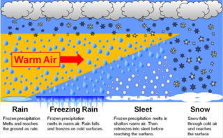
In meteorology, the various types of precipitation often include the character or phase of the precipitation which is falling to ground level. There are three distinct ways that precipitation can occur. Convective precipitation is generally more intense, and of shorter duration, than stratiform precipitation. Orographic precipitation occurs when moist air is forced upwards over rising terrain, such as a mountain.

In meteorology, station models are symbolic illustrations showing the weather occurring at a given reporting station. Meteorologists created the station model to fit a number of weather elements into a small space on weather maps. This allows map users to analyze patterns in atmospheric pressure, temperature, wind speed and direction, cloud cover, precipitation, and other parameters. The most common station plots depict surface weather observations although upper air plots at various mandatory levels are also frequently depicted.

Airport weather stations are automated sensor suites which are designed to serve aviation and meteorological operations, weather forecasting and climatology. Automated airport weather stations have become part of the backbone of weather observing in the United States and Canada and are becoming increasingly more prevalent worldwide due to their efficiency and cost-savings.

Surface weather observations are the fundamental data used for safety as well as climatological reasons to forecast weather and issue warnings worldwide. They can be taken manually, by a weather observer, by computer through the use of automated weather stations, or in a hybrid scheme using weather observers to augment the otherwise automated weather station. The ICAO defines the International Standard Atmosphere (ISA), which is the model of the standard variation of pressure, temperature, density, and viscosity with altitude in the Earth's atmosphere, and is used to reduce a station pressure to sea level pressure. Airport observations can be transmitted worldwide through the use of the METAR observing code. Personal weather stations taking automated observations can transmit their data to the United States mesonet through the Citizen Weather Observer Program (CWOP), the UK Met Office through their Weather Observations Website (WOW), or internationally through the Weather Underground Internet site. A thirty-year average of a location's weather observations is traditionally used to determine the station's climate. In the US a network of Cooperative Observers make a daily record of summary weather and sometimes water level information.
In aviation, ceiling is a measurement of the height of the base of the lowest clouds that cover more than half of the sky relative to the ground. Ceiling is not specifically reported as part of the METAR used for flight planning by pilots worldwide, but can be deduced from the lowest height with broken (BKN) or overcast (OVC) reported. A ceiling listed as "unlimited" means either that the sky is mostly free of cloud cover, or that the cloud is high enough not to impede Visual Flight Rules (VFR) operation.

Swiss International Air Lines Flight 850 was an international scheduled passenger flight from Basle, Switzerland, to Hamburg, Germany. On 10 July 2002, the flight was unable to land at Fuhlsbüttel Airport due to weather. Attempts were made to divert to other airports at Berlin and Eberswalde before the crew decided to land at Werneuchen. On landing, the aircraft struck an earth bank which ripped off all three undercarriage legs, and came to rest on its belly with an engine on fire. One of the sixteen passengers suffered minor injuries. The aircraft was written off.
References
- ↑ "Aerodrome Colour States" (PDF). CAA.co.uk. 2010-12-24. p. 10. Archived from the original (PDF) on 2012-09-10.
- ↑ "SafetySense :eaflet 26" (PDF). CAA.co.uk. 2010-12-24. Archived from the original (PDF) on 2012-09-10.
- ↑ "Aircrew Quick Reference to the METAR and TAF Codes" (PDF). Department of the Air Force. 2010-12-24. Archived from the original (PDF) on 2011-07-08.
- ↑ "Military color code". AirlineDispatch.com. 2010-12-24. Archived from the original on 2010-06-13.
- ↑ "METAR Decoder". SkyStef.be. 2010-12-24.