Glacier Bay National Park and Preserve is an national park of the United States located in Southeast Alaska west of Juneau. President Calvin Coolidge proclaimed the area around Glacier Bay a national monument under the Antiquities Act on February 26, 1925. Subsequent to an expansion of the monument by President Jimmy Carter in 1978, the Alaska National Interest Lands Conservation Act (ANILCA) enlarged the national monument by 523,000 acres on December 2, 1980, and created Glacier Bay National Park and Preserve. The national preserve encompasses 58,406 acres of public land to the immediate northwest of the park, protecting a portion of the Alsek River with its fish and wildlife habitats, while allowing sport hunting.

Glacier Bay Basin in southeastern Alaska, in the United States, encompasses the Glacier Bay and surrounding mountains and glaciers, which was first proclaimed a U.S. National Monument on February 25, 1925, and which was later, on December 2, 1980, enlarged and designated as the Glacier Bay National Park and Preserve under the Alaska National Interest Lands Conservation Act, covering an area of 3,283,000 acres. In 1986, UNESCO declared an area of 57,000 acres within a World Biosphere Reserve. This is the largest UNESCO protected biosphere in the world. In 1992, UNESCO included this area as a part of a World Heritage site, extending over an area of 24,300,000-acre (98,000 km2) which also included the Wrangell-St. Elias National Park, Kluane National Park (Canada) and Tatshenshini-Alsek Park (Canada). Part of the National Park is also designated a Wilderness area covering 2,658,000 acres.
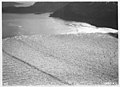
Muir Glacier is a glacier in Glacier Bay National Park and Preserve in the U.S. state of Alaska. It is currently about 0.7 km (0.43 mi) wide at the terminus. As recently as the mid-1980s the glacier was a tidewater glacier and calved icebergs from a wall of ice 90 m (200 feet) tall.

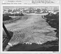
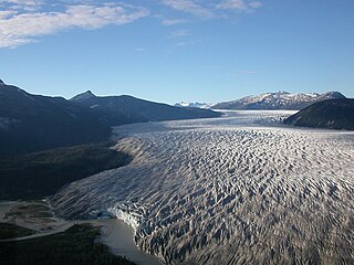
Taku Glacier is a tidewater glacier located in Taku Inlet in the U.S. state of Alaska, just southeast of the city of Juneau. Recognized as the deepest and thickest alpine temperate glacier known in the world, the Taku Glacier is measured at 4,845 feet (1,477 m) thick. It is about 58 kilometres (36 mi) long, and is largely within the Tongass National Forest.
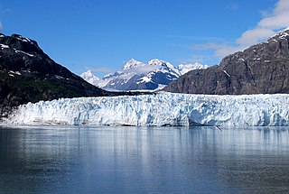
Margerie Glacier is a 21 mi (34 km) long tidewater glacier in Glacier Bay, Alaska, United States within the boundaries of Glacier Bay National Park and Preserve. The glacier begins on the southern slopes of Mount Root, elevation 12,860 feet (3,920 m), on the Alaska–Canada border flowing southeast down the valley, then turning to the northeast toward its terminus in Tarr Inlet. Margerie Glacier is one of the most active and frequently-visited glaciers in Glacier Bay, which was declared a National Monument in 1925, a National Park and Preserve in 1980, a UNESCO World Biosphere Reserve in 1986 and a World Heritage Site in 1992. While most of the tidewater glaciers in the park have been receding over the last several decades, Margerie Glacier has become stable, neither growing nor receding, while Johns Hopkins Glacier is advancing.

Grand Pacific Glacier is a 25 km (16 mi) long glacier in British Columbia and Alaska. It begins in Glacier Bay National Park in the Saint Elias Mountains, 7 km (4.3 mi) southwest of Mount Hay, trends east into the Grand Pacific Pass area of British Columbia, and then southeast to the head of Tarr Inlet at Alaska-Canada boundary, 68 miles (109 km) west of Skagway.

The Juneau Icefield is an ice field located just north of Juneau, Alaska, continuing north through the border with British Columbia, extending through an area of 3,900 square kilometres (1,500 sq mi) in the Coast Range ranging 140 km (87 mi) north to south and 75 km (47 mi) east to west. The icefield is the source of many glaciers, including the Mendenhall Glacier and the Taku Glacier. The icefield is home to over 40 large valley glaciers and 100 smaller ones. The Icefield serves as a tourist attraction with many travellers flown in by helicopter for quick walks on the 240-to-1,400-metre deep ice and the massive, awe-inspiring moist crevasses. The icefield, like many of its glaciers, reached its maximum glaciation point around 1700 and has been in retreat since. Much of the icefield is contained within the Tongass National Forest. Since 1948, the Juneau Icefield Research Program has monitored glaciers of the Juneau Icefield. On the west side of the icefield, from 1946-2009, the terminus of the Mendenhall Glacier has retreated over 700 metres (0.43 mi).

The retreat of glaciers since 1850 is a well-documented effect of climate change. The retreat of mountain glaciers provide evidence for the rise in global temperatures since the late 19th century. Examples include mountain glaciers in western North America, Asia, the Alps in central Europe, and tropical and subtropical regions of South America and Africa. Since glacial mass is affected by long-term climatic changes, e.g. precipitation, mean temperature, and cloud cover, glacial mass changes are one of the most sensitive indicators of climate change. The retreat of glaciers is also a major reason for sea level rise. Excluding peripheral glaciers of ice sheets, the total cumulated global glacial losses over the 26 years from 1993 to 2018 were likely 5500 gigatons, or 210 gigatons per year.

The Whitney Glacier is a glacier situated on Mount Shasta, in the U.S. state of California. The Whitney Glacier is the longest glacier and the only valley glacier in California. In area and volume, it ranks second in the state behind the nearby Hotlum Glacier. In 1986, the glacier was measured to be 126 ft (38 m) deep and over three km in length. The glacier starts on Mount Shasta's Misery Hill at 13,700 ft (4,200 m) and flows northwestward down to the saddle between Mount Shasta and Shastina, where uneven ground causes a major icefall at 11,800 ft (3,600 m). It then flows down the valley between the two peaks, reaching its terminus at 9,500 to 9,800 ft.

Jorge Montt Glacier is a tidewater glacier located in the Aisén Region of Chile, south of the town of Caleta Tortel. It lies at the north end of the Southern Patagonian Ice Field, within Bernardo O'Higgins National Park. The mouth of Pascua River is located in the vicinity of the glacier calving front.
The tidewater glacier cycle is the typically centuries-long behavior of tidewater glaciers that consists of recurring periods of advance alternating with rapid retreat and punctuated by periods of stability. During portions of its cycle, a tidewater glacier is relatively insensitive to climate change.

New Zealand contains many glaciers, mostly located near the Main Divide of the Southern Alps in the South Island. They are classed as mid-latitude mountain glaciers. There are eight small glaciers in the North Island on Mount Ruapehu.

Boston Glacier is located in a large cirque below several mountain peaks in North Cascades National Park in the U.S. state of Washington. Approximately 1 mi (1.6 km) long but nearly 3.5 mi (5.6 km) wide, it is the largest glacier in North Cascades National Park. Extending in an arc from the north of Forbidden Peak, it is flanked by Boston Peak to the southwest and Buckner Mountain at its eastern margin, between which it lies below the arête known as Ripsaw Ridge. Another arête extending between Boston Peak, Sharkfin Tower, Forbidden Peak and further north separate Boston Glacier from the nearly adjoining Quien Sabe and Forbidden Glaciers. Boston Glacier has been in an overall state of retreat since the end of the Little Ice Age around the year 1850. A moderate advance occurred between 1950 and the mid-1970s; however, the retreat resumed and between 1972 and 2006 its terminus retreated 1,470 ft (450 m).

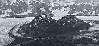
Mount Foresta is an 11,000+ ft multi-peak massif located in Wrangell–St. Elias National Park, in the Saint Elias Mountains of Alaska in the United States. Rising high above the lower western margin of the Hubbard Glacier, the summit of Mount Foresta is just over nine miles (14 km) from tidewater at Disenchantment Bay, 12 mi (19 km) northwest of Mount Seattle, 14.5 mi (23 km) southeast of Mount Vancouver, and 46 mi (74 km) north of Yakutat.

Mount Grosvenor is a 5,540-foot (1,689 m) elevation glaciated summit located 39 mi (63 km) west of Valdez in the Chugach Mountains of the U.S. state of Alaska, on land managed by Chugach National Forest. Although modest in elevation, relief is significant since the mountain rises from tidewater at Unakwik Inlet of Prince William Sound in approximately three miles. The mountain's name was applied in 1910 by Lawrence Martin, and officially adopted by the United States Geological Survey. This peak's name honors Gilbert Hovey Grosvenor (1875–1966), President of the National Geographic Society, father of photojournalism, and the first full-time editor of National Geographic magazine.
Great Nunatak is a 3,652-foot (1,113 m) elevation summit located 21 mi (34 km) west of Valdez in the Chugach Mountains of the U.S. state of Alaska. This remote mountain is situated near the terminus of the Columbia Glacier, 11 mi (18 km) southeast of Columbia Peak, on land managed by Chugach National Forest. This 2.2-mile long feature has a secondary summit, elevation 3,412 ft. Great Nunatak traces its name to Grove Karl Gilbert, a geologist with the United States Geological Survey who was part of the 1899 Harriman Alaska expedition that explored this area. He believed it to be the largest nunatak in Alaska when he casually referred to it as "the great nunatak" in a 1902 publication. The mountain's toponym was officially adopted in 1975 by the U.S. Board on Geographic Names. While the name remains, its status as a nunatak is obsolete because glacier lobes that once barely touched, now no longer completely encircle this landform as the Columbia Glacier retreats, and tidewater of Columbia Bay replaces the ice on the north and west aspects of the mountain.

Mount Cameron is a 5,360-foot (1,634 m) mountain summit located in the Chugach Mountains, in the U.S. state of Alaska. The peak is situated 15 mi (24 km) west-northwest of Valdez, Alaska, on the boundary of Chugach National Forest. Although modest in elevation, relief is significant since the southern aspect of the mountain rises up from the tidewater of Prince William Sound's Shoup Bay in approximately 4.4 miles. The mountain takes its name from local prospectors as reported in 1912 by the U.S. Geological Survey.

Mount Hogan is a 5,453-foot (1,662 m) mountain summit located in the Chugach Mountains, in the U.S. state of Alaska. The peak is situated 10.5 mi (17 km) northwest of Valdez, Alaska, and 6 mi (10 km) southeast of Mount Cameron. Although modest in elevation, relief is significant since the southern aspect of the mountain rises up from the tidewater of Prince William Sound's Port Valdez in approximately 3.4 miles. The mountain takes its name from local prospectors as reported in 1911 by the U.S. Geological Survey.

Tyndall Glacier is a valley/tidewater glacier in the U.S. state of Alaska. The glacier lies immediately west of 141° West longitude, within the boundaries of the Wrangell–Saint Elias Wilderness, itself part of Wrangell–St. Elias National Park & Preserve, in the borough of Yakutat, Alaska.

Gullied Peak is a 3,350-foot (1,021 m) mountain summit in the US state of Alaska.