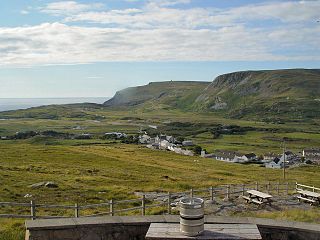
Gleann Cholm Cille, anglicised as Glencolumbkille or Glencolmcille, is a small district on the Atlantic coast of southwest County Donegal in Ireland. Named after Saint Colm Cille (Columba), it is also a civil parish in the historic barony of Banagh. Glencolmcille is in the Gaeltacht, and while it remains an Irish-speaking community, English has been steadily replacing Irish as the main language, with only 34% of residents speaking Irish on a daily basis in 2002. The village of Cashel is the main settlement in the district.

Knocknakilla is the site of a megalithic complex situated between Macroom and Millstreet, in County Cork, Ireland. It is set in blanket peatland on the north-west upper slopes of Musherabeg mountain and is thought to be 3500 years old.

Little Island, County Cork, is a civil parish and mainly industrial area to the east of Cork city in Ireland. It is no longer an island since the northern channel separating it from the mainland has filled over. To the west and south is Lough Mahon, part of Cork Harbour; across a channel to the east is Fota Island. Little Island is within the Dáil constituency of Cork North-Central.

Hugginstown is a small village and townland in south County Kilkenny, Ireland. The local Gaelic Athletic Association club, Carrickshock GAA, play their home games in the village.

Mullinavat is a town in south County Kilkenny, Ireland. Its main industries are tourism and agriculture. The town's name in Irish translates as 'mill of the stick' which, according to local tradition, may refer to a mill which could only be approached by means of a rough stick over the Glendonnel River, close to where Mullinavat Bridge is now located.

Farran is a village in County Cork, Ireland, in the parish of Ovens. It lies on the southside of the River Lee. Farran is 12 miles (19 km) west from Cork City on the N22 road.

Kilfane is a combination of two townlands located outside of Thomastown in County Kilkenny, Ireland. It is made up of the townlands of Kilfane East and West with a total area of 75 acres (0.30 km2). Located in the barony of Gowran, Kilfane gives its name to the wider civil parish which contains 16 townlands. It is in the Roman Catholic parish of Tullaherin.

Ballyvolane is a townland and suburb of Cork on the north side of the city. The townland of Ballyvolane is in the civil parish of St. Anne's Shandon. It is within the Cork North-Central Dáil constituency.
Kilcurl comprises the two townland areas of Kilcurl Anglesey and Kilcurl Feronsby. The townlands are situated one mile (1.6 km) from its nearest village, Knocktopher, and located on a road to Carrickshock monument one mile (1.6 km) away and two miles (3.2 km) to Ballyhale. The village of Knocktopher is situated in the parish of Ballyhale, south County Kilkenny, in Ireland.

Gowran is a barony in the east of County Kilkenny, Ireland. The size of the barony is 430.5 square kilometres (166.2 sq mi). There are 35 civil parishes in Gowran. The chief town today is Gowran. The barony contains the ecclesiastical sites of Kilfane and Duiske Abbey The barony of Gowran is situated in the east of the county between the baronies of Fassadinin to the north, the baronies of Kilkenny, Shillelogher and Knocktopher to the west, and the barony of Ida is to the south. It borders County Carlow to the east. The M9 motorway bisects the barony.

Kilmocar or Kilmacar is a townland and civil parish in County Kilkenny, Ireland. The ruins of a medieval church lie within Kilmacar townland.
Kilbeacon is a civil parish in the ancient barony of Knocktopher. It is located in the south of County Kilkenny, Ireland and is around 22 miles (35 km) south of the city of Kilkenny on the road to Waterford. The parish contains 3,151 statute acres. According to Lewis's survey of 1837, "At Earlsrath was a large fort, encompassed by a fosse and a bank about 20 feet high.". In 1833, there were 383 inhabited houses in the parish; of these, 270 families were primarily engaged in agriculture, 61 in manufactures or crafts, 52 in other. The total population was 2284 people.

Saint Margaret's is a civil parish and townland in the historical barony of Coolock in County Dublin, Ireland. Rivermeade, a housing estate of 175 homes which is treated as a separate census town, is located between Saint Margaret's and the Ward River. Dublin Airport is also nearby.
Lisdowney is a townland in County Kilkenny, Ireland. It lies on the River Nore near Ballyragget and is home to Lisdowney GAA club. The townland is in the civil parish of Aharney, within the historical barony of Galmoy, and in the electoral division of Lisdowney. As of the 2011 census, Lisdowney townland had a population of 93 people.
Garryvoe is a civil parish in the historical barony of Imokilly in County Cork, Ireland. The civil parish is centred on a small settlement, also referred to as Garryvoe, which lies on the R632 regional road between Ladysbridge, and Shanagarry and fronts onto Garryvoe Beach.

Kiltullagh is a village and civil parish in County Galway, Ireland. Located on the R348 regional road, the M6 motorway passes nearby. As of 2011, the townlands of Kiltullagh South and Kiltullagh North, in Kiltullagh civil parish, had a combined population of 93 people.

Cordal is a village and electoral division in County Kerry, Ireland. The townlands of Cordal East and Cordal West are in the civil parish of Ballincuslane and the historical barony of Trughanacmy. As of the 2011 census, Cordal East and Cordal West had populations of 115 and 117 residents respectively.

Kilfinny is a civil parish and townland in County Limerick, Ireland. It is close to Adare and Croom in the historical barony of Connello Upper.

Kilkeasy is a civil parish in the historical barony of Knocktopher in County Kilkenny, Ireland. Kilkeasy civil parish, which has an area of approximately 13.4 square kilometres (5.2 sq mi), contains the townlands of Ballybray, Kilkeasy and Knockmoylan. Kilkeasy also shares its name with a local electoral division.
