Colville Island is an island in the San Juan Islands of the U.S. state of Washington. It lies near Point Colville, on the southeastern tip of Lopez Island.
The island and the point were named for Andrew Colville, the governor of the Hudson's Bay Company, 1852–56. [1]
Marrowstone is a census-designated place (CDP) in Jefferson County, Washington, United States. The population was 844 at the 2010 census. All Marrowstone addresses are in Nordland, Washington, and the ZIP code for Marrowstone Island is 98358.

The SwinomishSWIN-ə-mish are an historically Lushootseed-speaking Native American people in western Washington state in the United States. The Tribe lives in the southeastern part of Fidalgo Island in northern Puget Sound, near the San Juan Islands, in Skagit County, Washington. Skagit County is located about 70 miles (110 km) north of Seattle.

Admiralty Inlet is a strait in the U.S. state of Washington connecting the eastern end of the Strait of Juan de Fuca to Puget Sound. It lies between Whidbey Island and the northeastern part of the Olympic Peninsula.

Franklin D. Roosevelt Lake is the reservoir created in 1941 by the impoundment of the Columbia River by the Grand Coulee Dam in Washington state. It is named for Franklin D. Roosevelt, who was president during the construction of the dam. Covering 125 square miles, it stretches about 150 miles (240 km) from the Canada–US border to Grand Coulee Dam, with over 600 miles (970 km) of shoreline; by surface area it is the largest lake and reservoir in Washington. It is the home of the Lake Roosevelt National Recreation Area.
Goose Island is one of the San Juan Islands in San Juan County, Washington, United States.

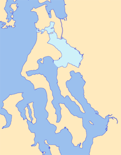
Fidalgo Island is an island in Skagit County, Washington, located about 60 mi (97 km) north of Seattle. To the east, it is separated from the mainland by the Swinomish Channel, and from Whidbey Island to the south by Deception Pass. The island is named after the Spanish explorer and cartographer Salvador Fidalgo, who explored the area in 1790.

Washington's 2nd congressional district includes all of Island and San Juan counties, and neighboring areas on the mainland, from Bellingham in the north to Lynnwood in the south. Before re-districting in 2012, the district encompassed the northern portion of Western Washington, from the vicinity of the King/Snohomish county line to the Canada–US border, including the San Juan Islands and the exclave of Point Roberts. Since 2001, it has been represented by Democrat Rick Larsen.

Padilla Bay is a bay located in the U.S. state of Washington, between the San Juan Islands and the mainland. Fidalgo Island and Guemes Island lie to the west of Padilla Bay. Guemes Channel, between the islands, connects Padilla Bay to Rosario Strait. Samish Island lies to the north of Padilla Bay, beyond which is Samish Bay and Bellingham Bay.
Possession Sound is part of Puget Sound, located in the U.S. state of Washington between Whidbey Island and the shoreline of Snohomish County approximately between the cities of Everett and Mukilteo. Possession Sound connects the main Puget Sound basin to the south with Saratoga Passage and Port Susan to the north. The Snohomish River flows into Possession Sound at Port Gardner Bay. Gedney Island, also called Hat Island, is located in Possession Sound.

Rosario Strait is a strait in northern Washington state, separating San Juan County and Skagit and Whatcom Counties. It extends from the Strait of Juan de Fuca about 23 kilometres (14 mi) north to the Strait of Georgia. The USGS defines its southern boundary as a line extending from Point Colville on Lopez Island to Rosario Head on Fidalgo Island, and its northern boundary as a line from Point Migley on Lummi Island to the east tip of Puffin Island and then to Point Thompson on Orcas Island. Rosario Strait runs north-south between Lopez, Decatur, Blakely, and Orcas Islands on the west, and Fidalgo, Cypress, Sinclair, and Lummi Islands on the east.
Skull Island is the name of two small islands in the San Juan Archipelago in the U.S. state of Washington. The northernmost Skull Island is located off the coast of Orcas Island in Massacre Bay, the most northern extension of the island's West Sound. It is identified as 3.2-acre (1.3 ha) Skull Island State Park Property by the Washington State Parks and Recreation Commission. It was named for holding skulls and bones of a band of Lummi who were killed by raiding Haida in 1858. Since 2013, it has been part of the San Juan Islands National Monument.
Iceberg Island is an island in the San Juan Islands of the U.S. state of Washington.
Castle Island is an island in the San Juan Islands of Washington state in the United States. It is located just off the southern tip of Lopez Island.
The Raccoon Strait is a waterway of the San Francisco Bay between Angel Island and the Tiburon Peninsula, mainland Marin County, California. During the ice ages, when sea levels were considerably lower and San Francisco Bay was a grassy valley, the combined Sacramento-San Joaquin river flowed through what is now Raccoon Strait before flowing through the canyon at the Golden Gate.
Skagit Bay is a bay and strait located in the U.S. state of Washington. It is part of the Whidbey Island Basin of Puget Sound. The Skagit River empties into Skagit Bay. To the south, Skagit Bay connects with the rest of Puget Sound via Saratoga Passage and Possession Sound. The boundary between Saratoga Passage and Skagit Bay is between Polnell Point on Whidbey Island and Rocky Point on Camano Island. To the northwest, Skagit Bay connects to the Strait of Juan de Fuca via the narrow strait of Deception Pass. A third waterway, the Swinomish Channel, connects Skagit Bay with Padilla Bay to the north.

The Kettle River Range, often called the Kettle Range, is the southernmost range of the Monashee Mountains, located in far southeastern British Columbia, Canada and Ferry County, Washington, in the United States. Most of the northern half of the range is protected by the Colville National Forest and the southern half of the range is located on the Colville Indian Reservation. The highest peak is Copper Butte, which reaches 2,177 metres (7,142 ft). The range is crossed by Washington State Route 20 at Sherman Pass.
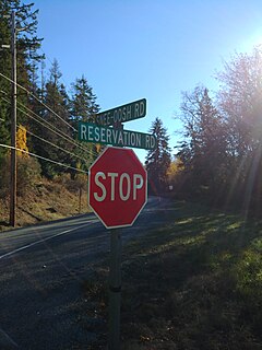
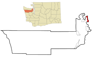
Snee Oosh is a populated place on Fidalgo Island in the U.S. state of Washington, on the Swinomish Indian Reservation. Population was reported as 302 in 1999.

Pinkney City was a small community outside of Fort Colville in what is now Stevens County (Washington). Originally named for Brevet Major Pinkney Lugenbeel, first commander and builder of the fort in 1859. The town grew up around the fort shortly after.
Beach is an unincorporated community on Lummi Island in Whatcom County, in the U.S. state of Washington.
Coordinates: 48°24′54″N122°49′19″W / 48.41500°N 122.82194°W
| | This San Juan County, Washington state location article is a stub. You can help Wikipedia by expanding it. |