Commissioners Park (Ottawa)

Last updated
Commissioners Park Commissioners Park Ottawa.jpg
Commissioners Park

Commissioners Park is a park in Ottawa, Ontario, Canada. It lies within the westernmost section of The Glebe, bounded by Dow's Lake, Preston Street, Carling Avenue and Dow's Lake Road.

Ottawa Federal capital city in Ontario, Canada

Ottawa is the capital city of Canada. It stands on the south bank of the Ottawa River in the eastern portion of southern Ontario. Ottawa borders Gatineau, Quebec; the two form the core of the Ottawa–Gatineau census metropolitan area (CMA) and the National Capital Region (NCR). As of 2016, Ottawa had a city population of 934,243 and a metropolitan population of 1,323,783 making it the fourth-largest city and the fifth-largest CMA in Canada.

The Glebe Neighbourhood in Ottawa, Ontario, Canada

The Glebe is a neighbourhood in Ottawa, Ontario, Canada. It is located just south of Ottawa's downtown area in the Capital Ward with its northern border being demarcated by Highway 417, the Queensway. It is bounded by the Rideau Canal to the south and east. Many maps show the western edge as Bronson Avenue, but some also include the triangle farther west formed by Bronson, Carling Avenue, and Dow's Lake. The Glebe Community Association uses the latter definition. As of 2011, the area's population was 11,184.

Dows Lake lake in Ontario, Canada

Dow's Lake in Ottawa, Ontario, Canada is a small man-made lake on the Rideau Canal, situated two kilometres north of Hog's Back Falls in the middle of Ottawa. It is at the south end of Preston Street, just south of Carling Avenue, and just to the west of Bronson Avenue. At the south end of the lake is Carleton University, and to the west is the Dominion Arboretum, at the edge of the Central Experimental Farm.

Throughout the warmer months it is a popular place for family walks. The National Capital Commission maintains the park and manages to keep flowers blooming there throughout the growing season. During the annual Tulip Festival, it is a major tulip viewing area with the highest concentration of tulips in the region numbering as many as 300,000.
National Capital Commission crown corporation of the Government of Canada

The National Capital Commission is the Canadian Crown corporation responsible for planning, as well as taking part in the development, conservation and improvement of Canada’s Capital Region. It administers a large number of federally owned lands and buildings in the National Capital Region.

Tulip genus of bulbous flowering plants

Tulips (Tulipa) form a genus of spring-blooming perennial herbaceous bulbiferous geophytes. The flowers are usually large, showy and brightly coloured, generally red, pink, yellow, or white. They often have a different coloured blotch at the base of the tepals, internally. Because of a degree of variability within the populations, and a long history of cultivation, classification has been complex and controversial. The tulip is a member of the Liliaceae (lily) family, along with 14 other genera, where it is most closely related to Amana, Erythronium and Gagea in the tribe Lilieae. There are about 75 species, and these are divided among four subgenera. The name "tulip" is thought to be derived from a Persian word for turban, which it may have been thought to resemble. Tulips originally were found in a band stretching from Southern Europe to Central Asia, but since the seventeenth century have become widely naturalised and cultivated. In their natural state they are adapted to steppes and mountainous areas with temperate climates. Flowering in the spring, they become dormant in the summer once the flowers and leaves die back, emerging above ground as a shoot from the underground bulb in early spring.

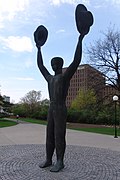
Man with Two Hats

Man With Two Hats Ottawa Statue.jpg
Man With Two Hats - Plaque.jpg
The statue and its plaque.

It features a sculpture Man with Two Hats by Henk Visch  [ nl ], commemorating the liberation of Holland by Canadian troops during World War II, which is identical to the National Canadian Liberation Monument in Apeldoorn, the Netherlands.

National Canadian Liberation Monument war memorial in Apeldoorn, Netherlands

The National Canadian Liberation Monument is a monument for the war in Apeldoorn, Netherlands, honouring the liberation of Holland. It features a sculpture Man with Two Hats by Henk Visch, which is identical to one in Commissioners Park in Ottawa.

Apeldoorn City and Municipality in Gelderland, Netherlands

Apeldoorn is a municipality and city in the province of Gelderland in the centre of the Netherlands. It is a regional centre. The municipality of Apeldoorn, including villages like Beekbergen, Loenen, Ugchelen and Hoenderloo, had a population of 160,852 in 2017. The western half of the municipality lies on the Veluwe ridge, the eastern half lies in the IJssel valley.

An explanatory plaque contains the following text:

During the Second World War, Canadian soldiers played a crucial role in the liberation of the Netherlands. With the donation of this monument - an expression of joy and a celebration of freedom - the Netherlands pays lasting tribute to Canada.
A statue identical to this one stands in Apeldoorn in the Netherlands. The twin monuments symbolically link Canada and the Netherlands; though separated by an ocean, the two countries will forever be close friends.
Her Royal Highness Princess Margriet of the Netherlands unveiled the monument in Ottawa on May 11, 2002, and the other in Apeldoorn on May 2, 2000.
Artist: Henk Visch

Coordinates: 45°23′54″N75°42′12″W / 45.3983°N 75.7034°W / 45.3983; -75.7034

Geographic coordinate system Coordinate system

A geographic coordinate system is a coordinate system that enables every location on Earth to be specified by a set of numbers, letters or symbols. The coordinates are often chosen such that one of the numbers represents a vertical position and two or three of the numbers represent a horizontal position; alternatively, a geographic position may be expressed in a combined three-dimensional Cartesian vector. A common choice of coordinates is latitude, longitude and elevation. To specify a location on a plane requires a map projection.

Related Research Articles

Liberation Day (Netherlands) Liberation Day in the Netherlands is celebrated each year on May 5th, to mark the end of the occupation by Nazi Germany during World War II.

In the Netherlands, Liberation Day is celebrated each year on May the 5th to mark the end of the occupation by Nazi Germany during World War II.

Netherlands Carillon

The Netherlands Carillon adjacent to Arlington National Cemetery was a gift from the people of the Netherlands to the people of the United States in 1954. The gift was made to thank the United States for its aid during and after World War II. First installed at a nearby site in 1954, the 49-bell carillon was moved to the present tower in 1960. A 50th bell was added following Dutch- and American-sponsored renovations in 1995, and dedicated on May 5, the 50th anniversary of the liberation of the Netherlands.

Winterlude

Winterlude is an annual winter festival held in Ottawa, Ontario and Gatineau, Quebec.

Tulip festival

Tulip Festivals are held in several cities around the world, mostly in North America — usually in cities with a Dutch heritage — such as Albany, New York; Ottawa, Ontario; Gatineau, Quebec; Montreal, Quebec; Holland, Michigan; Lehi, Utah; Orange City, Iowa; Pella, Iowa; Mount Vernon, Washington; and Woodburn, Oregon, and in other countries such as Australia India and England. The tulips are considered a welcome harbinger of spring, and a tulip festival permits residents to see them at their best advantage. The festivals are also popular tourist attractions. The tulips are displayed throughout the cities. In certain years the peak of tulips does not coincide with the actual festival due to climatic conditions.

Parks Canada Agency of the Government of Canada that administers parks

Parks Canada, officially called the Parks Canada Agency, is an agency of the Government of Canada run by a chief executive who answers to the Minister of the Environment and Climate Change. Parks Canada is mandated to "protect and present nationally significant examples of Canada's natural and cultural heritage, and foster public understanding, appreciation, and enjoyment in ways that ensure their ecological and commemorative integrity for present and future generations". Parks Canada manages 38 National Parks, three National Marine Conservation Areas, 171 National Historic Sites, one National Urban Park, and one National Landmark. The agency also administers lands and waters set aside as potential national parklands, including eight National Park Reserves and one National Marine Conservation Area Reserve. More than 450,000 km2 (170,000 sq mi) of lands and waters in national parks and national marine conservation areas has been set aside for such purposes. The Canadian Register of Historic Places is supported and managed by Parks Canada, in collaboration with provincial and territorial governments and other federal bodies. The agency is also the working arm of the national Historic Sites and Monuments Board, which recommends National Historic Sites, Events, and Persons.

Greenbelt (Ottawa) protected area of green space, including farms, forests and wetlands encircling Ottawa, Ontario, Canada

The Greenbelt is a 203.5-square-kilometre (78.6 sq mi) protected area of green space, including forests, farms, and wetlands, that encircles Canada's capital city of Ottawa, in the province of Ontario. It begins at Shirleys Bay in the west and extends to Green's Creek in the east. 149.5 square kilometres (57.7 sq mi) of the greenbelt is owned and managed by the National Capital Commission (NCC) and the rest is held by other federal government departments and private interests. Real estate development within the greenbelt is strictly controlled.

Green Island (Rideau River) island at the end of the Rideau River, Ontario, Canada

Green Island in Ottawa, Ontario, Canada, is an island at the junction of the Rideau River, just off Sussex Drive in Ottawa at the Rideau Falls at the confluence with the Ottawa River. It is situated near the neighbourhood of New Edinburgh.

Cartier Square Drill Hall drill hall in Ottawa, Canada

The Drill Hall at Cartier Square is a dedicated military training facility in Ottawa, Ontario, Canada. It has been a local landmark since its construction in 1879. The drill hall is 70 meters (230 ft) long and has two 43 meters (141 ft) tall mansard towers.

Ottawa City Hall

The current Ottawa City Hall is the city hall of Ottawa, Ontario, Canada. The downtown complex consists of two connected buildings: a modern wing located on Laurier Avenue and a 19th-century heritage wing located on Elgin Street. Although City Hall has frontage on two major streets, the main entrance is on Laurier Avenue, and the municipal address is 110 Laurier Avenue West.

Aberdeen Pavilion Exhibition hall in Ottawa

The Aberdeen Pavilion is an exhibition hall in Ottawa, Ontario, Canada. Overlooking the Rideau Canal, it is located in Lansdowne Park, Ottawa's historic fairgrounds. For many years, the building was known as the "Cattle Castle", due to its use for the Central Canada Exhibition's agricultural exhibits and shows, and some people still refer to it by this nickname today. It is the last surviving Canadian example of what was once a common form of Victorian exhibition hall, and was designated a National Historic Site of Canada in 1983.

National War Memorial (Canada) Canadian war memorial

The National War Memorial is a tall, granite memorial arch with accreted bronze sculptures in Ottawa, Ontario, Canada, designed by Vernon March and first dedicated by King George VI in 1939. Originally built to commemorate the Canadians who died in the First World War, it was in 1982 rededicated to also include those killed in the Second World War and Korean War and again in 2014 to add the dead from the Second Boer War and War in Afghanistan, as well as all Canadians killed in all conflicts past and future. It now serves as the pre-eminent war memorial of 76 cenotaphs in Canada. In 2000, the Tomb of the Unknown Soldier was added in front of the memorial and symbolizes the sacrifices made by all Canadians who have died or may yet die for their country.

Canadian Tulip Festival

The Canadian Tulip Festival is a tulip festival, held annually in May in Ottawa, Ontario, Canada. The festival claims to be the world's largest tulip festival, displaying over one million tulips, with attendance of over 650,000 visitors annually. Large displays of tulips are planted throughout the city, and the largest display of tulips is found in Commissioners Park on the shores of Dow's Lake, and along the Rideau Canal with 300,000 tulips planted there alone. Millions of tulips set the stage for a celebration of authentic art, cultural, historic, culinary and family tulip experiences at various official venues across the capital.

The Hull-Ottawa fire of 1900 was a devastating fire in 1900 that destroyed much of Hull, Quebec, and large portions of Ottawa, Ontario. On April 26 a defective chimney on a house in Hull caught fire, which quickly spread between the wooden houses due to windy conditions. Along the river were the large lumber companies, and huge amounts of stacked lumber that quickly ignited.

Peacekeeping Monument

Reconciliation: The Peacekeeping Monument is a monument in Ottawa, the capital of Canada, commemorating Canada's role in international peacekeeping and the soldiers who have participated and are currently participating, both living and dead.

Dominion Arboretum

The Dominion Arboretum is located at the Central Experimental Farm of Agriculture and Agri-Food Canada in Ottawa, Ontario, Canada. Originally begun in 1889 the Arboretum covers about 26 hectares of rolling land between Prince of Wales Drive, Dow's Lake and the Rideau Canal. Carleton University is located at the opposite side of the Canal. At a latitude of 45°, it can experience extremely hot and humid summers and extremely cold winters.

Vincent Massey Park park in Ottawa, Ontario, Canada

Vincent Massey Park is an urban park along the Rideau River in the Confederation Heights neighbourhood of Ottawa, Ontario, Canada, accessible via Heron Road. It is extensively used in the summer for family and group picnics.

Capital Pathway

The Capital Pathway, also known informally as the Bike Path, is a 220-kilometre (140 mi) recreational pathway interlinking many parks, waterways and sites in Ottawa, Ontario and Gatineau, Quebec. Most of the pathway is paved, and allows an almost continuous route through the National Capital Region.