
Davie Village is a neighbourhood in the West End of Vancouver, British Columbia, Canada. It is the home of the city's LGBT subculture, and, as such, is often considered a gay village, or gaybourhood. Davie Village is centred on Davie Street and roughly includes the area between Burrard and Jervis streets. Davie Street—and, by extension, the Village—is named in honour of A.E.B. Davie, eighth Premier of British Columbia from 1887 to 1889; A.E.B's brother Theodore was also Premier, from 1892 to 1895.

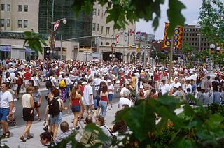
Rideau Street is a major street in downtown Ottawa, Ontario, Canada, and one of Ottawa's oldest and most famous streets running from Wellington Street in the west to Montreal Road in the east where it connects to the Vanier district. Rideau Street is home to the Château Laurier, the CF Rideau Centre and the Government Conference Centre. Along with Wellington Street and Sussex Drive it was among the first streets in Ottawa to be host to businesses; it was created with the founding of the early town. The Plaza Bridge by the Rideau Canal is at its westmost point and the Cummings Bridge is at its eastmost point.
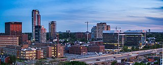
Little Italy is a neighbourhood of Ottawa, Ontario, Canada, and the cultural centre of Ottawa's Italian community. Situated in Centretown West, it is bounded by Albert Street to the north, Carling Avenue to the south, the O-Train Trillium Line to the west, and approximately Bronson Avenue to the east, while the neighbourhood's main commercial area is along Preston Street.
Wellington Street is a major street in Ottawa, Canada. It is notable for being the main street of the Parliamentary Precinct of the Parliament of Canada. It is one of the first two streets laid out in Bytown in 1826. The street runs from Vimy Place, just west of Booth Street, to the Rideau Canal where it connects with Rideau Street and delimits the northern border of the downtown core. It is named after the Duke of Wellington, in recognition of his role in the creation of the Rideau Canal, and therefore of Ottawa.
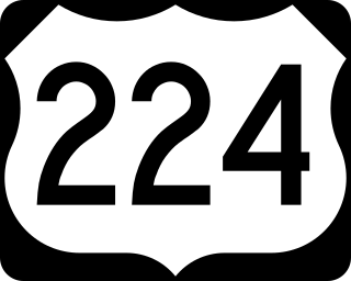
U.S. Route 224 (US 224) is a spur of US 24 that runs through the states of Indiana, Ohio and Pennsylvania. It currently runs for 289 miles (465 km) from US 24 in Huntington, Indiana, east to US 422 Business and Pennsylvania Route 18 (PA 18) in New Castle, Pennsylvania. It goes through the cities of Canfield, Ohio, Akron, Ohio, and Findlay, Ohio. In Northeast Ohio, US 224 is located a short distance north of the Western Reserve's southern boundary.

Sparks Street is a pedestrian mall in Ottawa, Ontario, Canada. It was a main street in Ottawa that was converted into an outdoor pedestrian street in 1967, making it the earliest such street or mall in Canada.
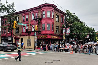
Commercial Drive is a roadway in the city of Vancouver in British Columbia, Canada, that extends from Powell Street at its northern extremity, near the waterfront, south through the heart of the Grandview–Woodland neighbourhood to the Victoria Diversion near Trout Lake. The neighbourhood is so dominated by the businesses, cultural facilities, and residents along Commercial Drive that the area is far better known as "The Drive" than by the civic boundaries. The district is one of Vancouver's Business Improvement Areas (BIA).

Little Italy is a neighborhood in downtown San Diego, California, that was originally a predominantly Italian and Portuguese fishing neighborhood. It is now a popular neighborhood consisting of Italian restaurants, grocery stores, home design stores, art galleries and residential units.

Queen Elizabeth Driveway is a scenic parkway in Ottawa, Ontario, Canada.

Hintonburg is a neighbourhood in Kitchissippi Ward in Ottawa, Ontario, Canada, located west of the Downtown core. It is a historically working-class, predominantly residential neighbourhood, with a commercial strip located along Wellington Street West. It is home to the Parkdale Public Market, located along Parkdale Avenue, just north of Wellington. It is considered to be one of Ottawa's most "hipster" neighbourhoods.
Innes Road is one of the most important corridors in the east end of the City of Ottawa, Ontario, Canada, running through the former cities of Gloucester and Cumberland. It is the main route serving Blackburn Hamlet and south Orléans, as well as several industrial and commercial areas in east Ottawa.

Elgin Street is a street in the Downtown core of Ottawa, Ontario, Canada. Originally named Biddy's Lane, it was later named after Lord Elgin.
Lower Town (also spelled "Lowertown" is a neighbourhood in Rideau-Vanier Ward in central Ottawa, Ontario, Canada, to the east of downtown. It is the oldest part of the city. It is bounded by Rideau Street to the south, the Ottawa River to the west and north and the Rideau River to the east. It includes the commercial Byward Market area in the south-western part, and is predominantly residential in the north and east.
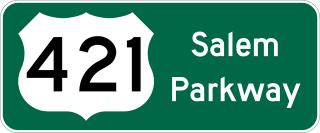
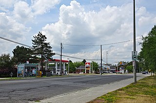
The Salem Parkway is an 18.5-mile-long (29.8 km) freeway in the U.S. state of North Carolina, serving the city of Winston-Salem and the town of Kernersville. It is signed as U.S. Route 421 (US 421) for its entire length, though it is also concurrent with US 158 in downtown Winston-Salem and North Carolina Highway 150 (NC 150) between Winston-Salem and Kernersville. Originally known as the East–West Expressway, it was designated as part of Interstate 40 (I-40) and opened in 1958, becoming the first section of Interstate Highway in the state. I-40 was rerouted onto a new alignment bypassing Winston-Salem and Kernersville in 1992, at which time the road was designated Interstate 40 Business, nicknamed Business 40.

U.S. Route 62 Business is a business route of US 62 located within the city of Niagara Falls, New York, in the United States. It follows Pine Avenue through downtown Niagara Falls, spanning 2.12 miles (3.41 km) between New York State Route 104 (NY 104) at its western terminus and US 62 at its eastern extent. Although it runs in a mostly east–west direction, it is signed as a north–south route due to US 62 being signed north–south as well within New York.

The Iron Horse Trail is a multi-use urban rail trail which connects the cities of Waterloo and Kitchener, Ontario, Canada. It runs from Erb Street West in the north near Uptown Waterloo, to Ottawa Street South in Kitchener to the south. It covers a distance of 5.5 kilometres (3.4 mi). The trail was opened on 5 October 1997 on abandoned Canadian Pacific Railway right of way sections, including portions of the right-of-way of the now-defunct Grand River Railway. The two cities combined resources to purchase the property. It is a part of the Trans Canada Trail.
McCauley is an ethnically diverse inner city neighbourhood in Edmonton, Alberta, undergoing revitalization. It is named for Matthew McCauley, the first mayor of Edmonton, and is located just to the north east of the Downtown core. McCauley is known as the home of religious buildings in a small area, as well as being a large venue for the 1978 Commonwealth Games.

Nutana Park is a mostly residential neighbourhood located in south-central Saskatoon, Saskatchewan, Canada. It is a suburban subdivision, consisting mostly of low-density, single detached dwellings. As of 2021, the area is home to 2,959 residents. The neighbourhood is considered a middle-income area, with an average personal income of $42,630 and a home ownership rate of 83.3%. According to MLS data, the average sale price of a home as of 2020 was $346,929.

Stockton Street is a north-south street in San Francisco. It begins at Market Street passing Union Square, a major shopping district in the city. It then runs underground for about two and a half blocks in Stockton Street Tunnel, passes through Chinatown and North Beach, and ends at Beach Street near the Pier 39 shopping center and tourist attraction.

Ottawa's Chinatown is located along Somerset Street west of downtown Ottawa. It runs from Bay Street in the east to Preston Street in the west. Signs for Chinatown continue along Somerset until Preston Street, and Chinese/Asian restaurants can be found even farther west.

