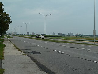
Prince of Wales Drive is the road in the centre of the photo along the Rideau River.Prince of Wales Drive at Hog's Back Road and Meadowlands Drive
Prince of Wales Drive (Ottawa Road #73) is a road serving Ottawa, Ontario. The northern section is a low-speed street running along the west bank of the Rideau River, while southern portions of the road were formerly Highway 16 (downgraded after the construction of Highway 416).
Prince of Wales Drive follows the Rideau River past Barrhaven and Manotick. South of the intersection with Jockvale Road, the road diverts from the river and heads in a southwesterly direction toward North Gower, where it terminates at Fourth Line Road.
In May 2007, the City approved the start of an environmental assessment study in regards of the future widening of the road from Fisher Avenue to Woodroffe Avenue from two to four lanes in accommodation to future expansion in Barrhaven, Manotick and Riverside South.
Bank Street is the major commercial north-south street in Ottawa, Ontario, Canada. It runs south from Wellington Street in downtown Ottawa, south through the neighbourhoods of Centretown, The Glebe, Old Ottawa South, Alta Vista, Hunt Club, and then through the villages of Blossom Park, Leitrim, South Gloucester, Greely, Metcalfe, Spring Hill, and Vernon before ending at the city limit at Belmeade Road, becoming Stormont, Dundas and Glengarry county highway 31.
Hunt Club Road, also known as Ottawa Road 32, is a major east–west route in Ottawa, Ontario, Canada. It originally ran from a dead end east of Bank Street to the Ottawa Hunt and Golf Club; later, there were many extensions due to the 1970s housing boom, first westward to Riverside Drive, then eastward to Hawthorne Road in the late 1980s. The section between Bank Street and Riverside Drive, originally only one lane in each direction, was expanded to two lanes in each direction in 1993–1994. It was further extended across the Rideau River and the southern edge of the suburbs to Richmond Road by the late 1990s; this extension is signed as West Hunt Club Road by the City of Ottawa. Construction to extend Hunt Club eastward to Highway 417 near Ramsayville was completed on August 21, 2014.
Riverside Drive is a major road in Ottawa, Ontario, Canada, that follows along the eastern bank of the Rideau River. Its northern terminus is at the Transitway/Via Rail underpass just south of the Queensway, and the road proceeds south to Limebank Road where it continues as River Road until the city limits. North of the Queensway, Riverside continues as Vanier Parkway, which travels through Vanier until Beechwood Avenue. The Vanier Parkway name is linked to the neighbourhood of Vanier, which was named for former Governor General of Canada Georges Vanier.
Heron Road is a major road in Ottawa, Ontario, Canada. It runs from Walkley Road at an angle to the Rideau River, where it turns into Baseline Road. Heron is home to the Sir Leonard Tilley Building, the Canada Post headquarters, and the Edward Drake Building. It is also home to St. Patrick's Intermediate High School and Herongate Mall.
Baseline Road is a road in Ottawa, Ontario, Canada.
Barrhaven is a suburb of Ottawa, Ontario, Canada. It is located about 17 km (11 mi) southwest of the city's downtown core. Prior to amalgamation with Ottawa in 2001, Barrhaven was part of the City of Nepean. Its population as of the Canada 2021 Census was 103,234.
King's Highway 416, commonly referred to as Highway 416 and as the Veterans Memorial Highway, is a 400-series highway in the Canadian province of Ontario that connects the Trans-Canada Highway (Highway 417) in Ottawa with Highway 401 between Brockville and Cornwall. The 76.4-kilometre-long (47.5 mi) freeway acts as an important trade corridor from Interstate 81 between New York and Eastern Ontario via Highway 401, as well as the fastest link between Ottawa and Toronto. Highway 416 passes through a largely rural area, except near its northern terminus where it enters the suburbs of Ottawa. The freeway also serves several communities along its length, notably Spencerville and Kemptville.
Carling Avenue is a major east–west arterial road in the west end of Ottawa, Ontario, Canada. It runs from March Road in Kanata to Bronson Avenue in the Glebe. The road is named for John Carling, founder of Carling Brewery and Conservative MP and Senator, Postmaster General and Minister of Agriculture.
Alta Vista Drive is a suburban road in Ottawa, Ontario, Canada. It runs from Bank Street in the south to Industrial Avenue in the north covering the neighbourhoods of Ridgemont, Alta Vista and Riverview.
Queen Elizabeth Driveway is a scenic parkway in Ottawa, Canada, that runs along the western edge of the Rideau Canal. It runs from Laurier Avenue in the north to Dow's Lake where it turns into Prince of Wales Drive. It is administered and owned by the National Capital Commission (NCC).
Woodroffe Avenue is a major north-south arterial road in Ottawa, Ontario, Canada's west end. It runs south from the Kichi Zibi Mikan through Baseline Road and Barrhaven to just short of Prince of Wales Drive near Manotick. The road runs through the heart of Nepean in Ottawa's west end. A satellite Via Rail station is also located at the intersection of Fallowfield Road.
Hazeldean Road is a major road in Ottawa's west end. This road runs between the junction of Highway 7 west of Stittsville and Eagleson Road in Kanata, where it becomes Robertson Road east of the intersection and proceeds towards Bells Corners in the former city of Nepean, Ontario as a four-lane rural route through the Greenbelt.
Merivale Road is an arterial road in the west end of Ottawa, Ontario, Canada. It starts at Island Park Drive just north of Highway 417 and continues south until it ends at Prince of Wales Drive in Rideau Glen. South of Clyde Avenue, Merivale is known as Ottawa Road #17, while north of Clyde it is Ottawa Road #63.
Meadowlands Drive is a suburban road in Ottawa, Ontario, Canada. It begins at Prince of Wales Drive as a continuation of Hog's Back Road in the neighborhood of Rideauview. There are two small shopping plazas and a Shell station at its corner with Prince of Wales. It then continues westward towards Fisher Avenue and consists of low-income housing projects, low-rise apartment buildings, townhouses and semi-detached homes. The speed limit here is 50 km/h (31 mph). most of Meadowlands is one lane, other than between Prince of Wales to Fisher, and from Chesterton to Merivale.
Cedarview Road is a north–south road in Ottawa, Ontario, Canada. It runs between Bells Corners and Barrhaven. Formerly a major arterial road for Barrhaven residents, its use declined after the opening of Highway 416 in 1999.
Strandherd Drive is a major road serving the community of Barrhaven in southwest Ottawa.
Nicholas Street is an arterial road in the central area of Ottawa, Ontario which connects Highway 417 with the downtown core. Despite being a municipal road, the street is designated as part of Canada's National Highway System, as part of an interconnecting route between Highway 417 and Quebec Autoroute 5 in Gatineau.
Terry Fox Drive is a major arterial road in Ottawa, Ontario named for the late Canadian humanitarian, activist, and athlete Terry Fox. Located in the suburb of Kanata in the city's west end, the road is a major route for residents traveling to/from the north end of Kanata. Starting in the Kanata North Technology Park at an intersection with Herzberg Road, it crosses March Road and Innovation Drive and bisects an old-growth forest, before heading south past Kanata Centrum. It crosses Highway 417, passes Katimavik-Hazeldean and Glen Cairn, and ends at Eagleson Road, where it continues east as Hope Side Road. Currently, Terry Fox Drive is a four lane arterial between just north of Richardson Side Road and just south of Winchester Drive, and a two lane undivided road elsewhere.
This page is based on this Wikipedia article Text is available under the CC BY-SA 4.0 license; additional terms may apply. Images, videos and audio are available under their respective licenses.