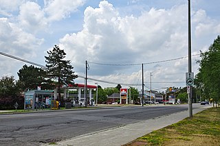
Most of the Kanata section of the road is commercial and includes Hazeldean Mall (although it actually faces Eagleson Road), a key shopping centre in the Kanata area. It is a four-lane road, with a 60km/h (37mph) speed limit between Terry Fox Drive and Eagleson Road. West of Kanata towards Highway 7, it is mostly a two-lane rural route, although work was completed in Spring 2012 to widen the road to four lanes due to the increasing amount of traffic coming from Stittsville's growing community. The speed limit west of Terry Fox Drive was 70–80km/h (43–50mph) prior to road widening.
The widening of Hazeldean Road was completed in early 2012 between West Ridge Drive and Terry Fox Drive in Kanata and includes a unique suspension bridge over the Carp River. The speed limit in this section is 60km/h (37mph). Several strip malls and big-box stores have recently opened along Hazeldean Road, including Lowe's, Winners, Shoppers Drug Mart, and Food Basics. Restaurants such as Five Guys, Subway, Mr. Shawarma, and several others have also recently opened or are under construction in the area.
A new water main was installed between Terry Fox Drive and Castlefrank Road. The installation must be completed before construction can resume in the new subdivision of Kanata West, located near Huntmar Drive north of Hazeldean Road. A portion of the construction between Terry Fox Drive and Young Road was completed during the summer/fall of 2012, with the remainder completed in the fall of 2013.
Kanata is a suburb and former city within Ottawa, Ontario, Canada. It is located about 22 km (14 mi) west of the city's downtown core. As of 2021, the former City of Kanata had a population of 98,938, with the population centre having a population of 137,118. Before it was amalgamated into Ottawa in 2001, it was one of the fastest-growing cities in Canada and the fastest-growing community in Eastern Ontario. Located just to the west of the National Capital Commission Greenbelt, it is one of the largest of several communities that surround central Ottawa.
Hunt Club Road, also known as Ottawa Road 32, is a major east–west route in Ottawa, Ontario, Canada. It originally ran from a dead end east of Bank Street to the Ottawa Hunt and Golf Club; later, there were many extensions due to the 1970s housing boom, first westward to Riverside Drive, then eastward to Hawthorne Road in the late 1980s. The section between Bank Street and Riverside Drive, originally only one lane in each direction, was expanded to two lanes in each direction in 1993–1994. It was further extended across the Rideau River and the southern edge of the suburbs to Richmond Road by the late 1990s; this extension is signed as West Hunt Club Road by the City of Ottawa. Construction to extend Hunt Club eastward to Highway 417 near Ramsayville was completed on August 21, 2014.
King's Highway 417, commonly referred to as Highway 417 and as the Queensway through Ottawa, is a 400-series highway in the Canadian province of Ontario. It connects Ottawa with Montreal via A-40, and is the backbone of the highway system in the National Capital Region. Within Ottawa, it forms part of the Queensway west from Highway 7 to Ottawa Road 174. Highway 417 extends from the Quebec border, near Hawkesbury, to Arnprior, where it continues westward as Highway 17. Aside from the urban section through Ottawa, Highway 417 passes through farmland that dominates much of the fertile Ottawa Valley.
Carling Avenue is a major east–west arterial road in the west end of Ottawa, Ontario, Canada. It runs from March Road in Kanata to Bronson Avenue in the Glebe. The road is named for John Carling, founder of Carling Brewery and Conservative MP and Senator, Postmaster General and Minister of Agriculture.
Innes Road is one of the most important corridors in the east end of the City of Ottawa, Ontario, Canada, running through the former cities of Gloucester and Cumberland. It is the main route serving Blackburn Hamlet and south Orléans, as well as several industrial and commercial areas in east Ottawa.
St. Laurent Boulevard is an arterial road in Ottawa, Ontario, Canada. Beginning at the Royal Canadian Mounted Police college complex at Sandridge Road in the Manor Park neighbourhood, St. Laurent Boulevard runs in a straight line, slightly east of south, until it reaches Walkley Road. It then curves west and intersects with Conroy Road and Don Reid Drive. In Ottawa, the name of the street is pronounced exclusively in French, even among Anglophones, as it honours former Canadian Prime Minister Louis St. Laurent. Prior to 1951, it was known as Base Line Road.
Terry Fox station is a bus stop on Ottawa, Ontario, Canada's transitway served by OC Transpo buses and named after cancer research activist Terry Fox. It is located in the western transitway section and is the main western terminal of routes 61 and 62 for all trips not extended to/from Stittsville.
Stittsville Transitway Station is a bus-stop on Ottawa, Ontario's transitway served by OC Transpo buses. It located on Shea Road at the Goulbourn Recreation Complex in Stittsville, Ontario.
Eagleson Road is a northwest–southeast road in Ottawa's west end in Kanata. It starts at Highway 417 and ends at Brophy Drive south of Richmond. North of Highway 417 it becomes March Road. It is a key link, primarily for residents of Bridlewood, between both ends of Kanata where housing developments are growing steadily in the north and the south. The primary segment of Eagleson Road is divided and six lanes wide between Highway 417 and Abbeyhill Drive, while between Abbeyhill Drive and just south of Stonehaven Drive it is a four-lane divided arterial. South of that, Eagleson is a two-lane undivided rural road.
Carp Road is an arterial road in Ottawa, Ontario, Canada that runs between Fitzroy Harbour and Stittsville, through the village of Carp. The road is located in the city's west end, beginning in Fitzroy Harbour at Galetta Side Road and ending in Stittsville at Stittsville Main Street. Most of the route is rural with the exception of Stittsville where the road travels in a residential development. Ottawa Regional Road #5 continues as Stittsville Main Street south of Carp Road, then becomes Huntley Road south of Stittsville toward the town of Richmond.
Prince of Wales Drive is a road serving Ottawa, Ontario. The northern section is a low-speed street running along the west bank of the Rideau River, while southern portions of the road were formerly Highway 16.
Terry Fox Drive is a major arterial road in Ottawa, Ontario named for the late Canadian humanitarian, activist, and athlete Terry Fox. Located in the suburb of Kanata in the city's west end, the road is a major route for residents traveling to/from the north end of Kanata. Starting in the Kanata North Technology Park at an intersection with Herzberg Road, it crosses March Road and Innovation Drive and bisects an old-growth forest, before heading south past Kanata Centrum. It crosses Highway 417, passes Katimavik-Hazeldean and Glen Cairn, and ends at Eagleson Road, where it continues east as Hope Side Road. Currently, Terry Fox Drive is a four lane arterial between just north of Richardson Side Road and just south of Winchester Drive, and a two lane undivided road elsewhere.
Hazeldean Mall is a shopping centre located in the Kanata district of Ottawa, Ontario, Canada. It is located at the intersection of Eagleson Road and Hazeldean Road, where Hazeldean Road turns into Robertson Road. It was the first enclosed shopping centre constructed in Kanata. The development of the mall was approved shortly before the incorporation of the (then) City of Kanata, and its approval led to a legal battle between the constituent parts of the new municipality over the appropriate location of what would at that time be the new city's main commercial hub.
Robertson Road is a road in the west end of Ottawa, Ontario, Canada. It runs approximately 6.1 km (3.8 mi) between Baseline Road east of Bells Corners and Eagleson Road in Kanata where the road continues west as Hazeldean Road. At Baseline Road it continues east as Richmond Road.
Glen Cairn is a neighbourhood in Kanata South Ward in the west end of Ottawa, Ontario, Canada. It is also the name of a public school in the area. Prior to amalgamation in 2001, it was located in the City of Kanata. It is located in South Kanata, about 22 km (14 mi) west of Downtown Ottawa. It was one of the original neighbourhoods in Kanata. The community was built in the 1960s, and was part of Goulbourn Township until the creation of Kanata in 1978. As of the Canada 2016 Census, there were 11,836 people living in Glen Cairn.
Katimavik-Hazeldean is a neighbourhood in Kanata South Ward in the west end of Ottawa, Ontario, Canada. It is located in the former City of Kanata which amalgamated into Ottawa in 2001. It is located in south-central Kanata, bounded by Eagleson Road to the east, Hazeldean Road to the south, the Carp River to the west, and Highway 417 to the north.
The Kanata Town Centre is a three-storey office building with a smaller one-storey retail component in the city of Ottawa, Ontario, Canada. It is located at 150 Katimavik Road, south of Highway 417, in the Katimavik-Hazeldean community of the Kanata area. It contains approximately 10,000 square metres (110,000 sq ft) of gross floor area. Once intended as the first phase of a central business district for the (then) City of Kanata, the focal point of the planned commercial core for Kanata was later shifted to lands to the north of Highway 417. The office component of the Kanata Town Centre served as the City of Kanata's first permanent city hall.
Kanata—Carleton is a federal electoral district in Ottawa, Ontario.
Kanata—Carleton is a provincial electoral district in Ottawa, Ontario which was first contested in the 2018 provincial election.
This page is based on this Wikipedia article Text is available under the CC BY-SA 4.0 license; additional terms may apply. Images, videos and audio are available under their respective licenses.