
A parkway is a landscaped thoroughfare. The term is particularly used for a roadway in a park or connecting to a park from which trucks and other heavy vehicles are excluded.

Hunt Club Road, also known as Ottawa Road 32, is a major east–west route in Ottawa, Ontario, Canada. It originally ran from a dead end east of Bank Street to the Ottawa Hunt and Golf Club; later, there were many extensions due to the 1970s housing boom, first westward to Riverside Drive, then eastward to Hawthorne Road in the late 1980s. The section between Bank Street and Riverside Drive, originally only one lane in each direction, was expanded to two lanes in each direction in 1993–1994. It was further extended across the Rideau River and the southern edge of the suburbs to Richmond Road by the late 1990s; this extension is signed as West Hunt Club Road by the City of Ottawa. Construction to extend Hunt Club eastward to Highway 417 near Ramsayville was completed on August 21, 2014.
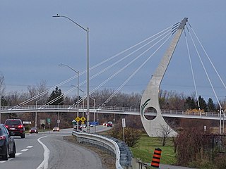
Airport Parkway is an expressway in Ottawa, Ontario, Canada. It runs from the Ottawa Macdonald–Cartier International Airport to an interchange with Heron Road where it turns into Bronson Avenue.

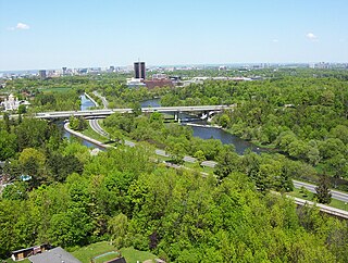
Riverside Drive is a major road in Ottawa, Ontario, Canada, that follows along the eastern bank of the Rideau River. Its northern terminus is at the Transitway/Via Rail underpass just south of the Queensway, and the road proceeds south to Limebank Road where it continues as River Road until the city limits. North of the Queensway, Riverside continues as Vanier Parkway, which travels through Vanier until Beechwood Avenue. The Vanier Parkway name is linked to the neighbourhood of Vanier, which was named for former Governor General of Canada Georges Vanier.

Sussex Drive, also known as Ottawa Regional Road 93, is an arterial road in Ottawa, Ontario, the capital of Canada. It is one of the city's main ceremonial and institutional routes. Travelling roughly parallel to the Ottawa River, Sussex Drive begins as a continuation of Sir George-Étienne Cartier Parkway at Rideau Gate, at the entrance to Rideau Hall. It travels south to Rideau Street, with the portion south of St. Patrick Street forming the northbound half of a one-way pair with Mackenzie Avenue. Both Mackenzie Avenue and Sussex Drive connect with Colonel By Drive at their southern end, which continues south alongside the Rideau Canal.
Russell Road is an arterial road in Eastern Ontario, Canada. It begins in Ottawa in the Riverview neighbourhood and runs eastward through the rural communities of Ramsayville, Carlsbad Springs and Bearbrook in Ottawa and through the Municipality of Clarence-Rockland, connecting the communities of Cheney and Bourget, ending at Boundary Road on the eastern border of Clarence Rockland. In Ottawa it is officially Ottawa Road #26, and in Clarence-Rockland as United Counties of Prescott and Russell County Road #2.
King's Highway 7, commonly referred to as Highway 7 and historically as the Northern Highway, is a provincially maintained highway in the Canadian province of Ontario. At its peak, Highway 7 measured 716 km (445 mi) in length, stretching from Highway 40 east of Sarnia in Southwestern Ontario to Highway 17 west of Ottawa in Eastern Ontario. However, due in part to the construction of Highways 402 and 407, the province transferred the sections of Highway 7 west of London and through the Greater Toronto Area to county and regional jurisdiction. The highway is now 535.7 km (332.9 mi) long; the western segment begins at Highway 4 north of London and extends 154.1 km (95.8 mi) to Georgetown, while the eastern segment begins at Donald Cousens Parkway in Markham and extends 381.6 km (237.1 mi) to Highway 417 in Ottawa.
King's Highway 417, commonly referred to as Highway 417 and as the Queensway through Ottawa, is a 400-series highway in the Canadian province of Ontario. It connects Ottawa with Montreal via A-40, and is the backbone of the highway system in the National Capital Region. Within Ottawa, it forms part of the Queensway west from Highway 7 to Ottawa Road 174. Highway 417 extends from the Quebec border, near Hawkesbury, to Arnprior, where it continues westward as Highway 17. Aside from the urban section through Ottawa, Highway 417 passes through farmland that dominates much of the fertile Ottawa Valley.
Colonel By Drive is an 8.1 km (5.0 mi) long scenic parkway in Ottawa, Ontario, Canada.

Carling Avenue is a major east–west arterial road in the west end of Ottawa, Ontario, Canada. It runs from March Road in Kanata to Bronson Avenue in the Glebe. The road is named for John Carling, founder of Carling Brewery and Conservative MP and Senator, Postmaster General and Minister of Agriculture.

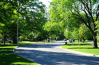
Queen Elizabeth Driveway is a scenic parkway in Ottawa, Ontario, Canada.

The Kichi Zībī Mīkan, formerly the Sir John A. Macdonald Parkway, and previously the Ottawa River Parkway, is a four-lane scenic parkway along the Ottawa River in Ottawa, Ontario, Canada. It runs from Carling Avenue near Connaught Avenue, to Booth Street at the Canadian War Museum and National Holocaust Monument. It is maintained by the National Capital Commission. The speed limit is 60 km/h (37 mph). Bicycles are allowed on the road and on a parallel recreational path along the parkway.
Island Park Drive is a scenic parkway in Ottawa, Ontario, Canada.

Bronson Avenue is a major north-south arterial road in Ottawa, Ontario, Canada. It starts at the south end as a continuation of the Airport Parkway, which is an expressway to the Macdonald-Cartier International Airport. It continues past Carleton University, the Glebe, north through Centretown, and ends downtown at Sparks Street.

Albion Road is an important north–south road in the southern part of Ottawa, Ontario, Canada. The street begins in the north as Albion Road North, at Walkley Road.
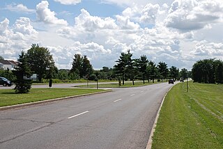
The Aviation Parkway is a scenic parkway in Ottawa, Ontario, Canada.
Carp Road is an arterial road in Ottawa, Ontario, Canada that runs between Fitzroy Harbour and Stittsville, through the village of Carp. The road is located in the city's west end, beginning in Fitzroy Harbour at Galetta Side Road and ending in Stittsville at Stittsville Main Street. Most of the route is rural with the exception of Stittsville where the road travels in a residential development. Ottawa Regional Road #5 continues as Stittsville Main Street south of Carp Road, then becomes Huntley Road south of Stittsville toward the town of Richmond.

Hog's Back Road is a 1 km (0.62 mi) road in Ottawa, Ontario, Canada. The road connects Meadowlands Drive and Prince of Wales Drive to Riverside Drive and Brookfield Road. The road is used as the boundary line between Mooney's Bay Park and Hog's Back Park. It goes over the dam creating Mooney's Bay and Hog's Back Falls, and continues over the Hog's Back swing bridge over the Rideau Canal, to allow taller boats navigating the canal to pass. The road also runs past the spot where the Rideau Canal separates from the Rideau River.

The Sir George-Étienne Cartier Parkway, formerly known as the Rockcliffe Parkway, is a parkway in Ottawa, Ontario, Canada.
