Sandy Hill is a neighbourhood in Ottawa, Ontario, located just east of downtown. The neighbourhood is bordered on the west by the Rideau Canal, and on the east by the Rideau River. To the north it stretches to Rideau Street and the Byward Market area while to the south it is bordered by the Queensway highway and Nicholas Street. The area is named for its hilliness, caused by the river, and its sandy soil, which makes it difficult to erect large buildings. It is home to a number of embassies, residences and parks. Le cordon bleu operates its Canadian school there, at the opposite end of Sandy Hill from the University of Ottawa.

The Glebe is a neighbourhood in Ottawa, Ontario, Canada. It is located just south of Ottawa's downtown area in the Capital Ward. According to the Glebe Community Association, the neighbourhood is bounded on the north by the Queensway, on the east and south by the Rideau Canal and on the west by LeBreton Street South, Carling Avenue and Dow's Lake. As of 2016, this area had a population of 13,055. This area includes the Glebe Annex, an area west of Bronson Avenue, north of Carling Avenue, east of LeBreton South Street and south of the Queensway, that maintains its own neighbourhood association - the Glebe Annex Community Association (GACA).. The Glebe also includes the Dow's Lake neighbourhood, an area north of the Rideau Canal, east of Dow's Lake, south of Carling Avenue and west of Bronson, that maintains its own neighbourhood association - the Dow's Lake Residents Association (DLRA).
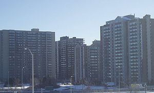
Riverview is a neighbourhood in Ottawa, Ontario, Canada. It is southeast of the downtown adjacent to the Rideau River, its location on which is its namesake. The 2021 Census population of Riverview is 13,113.

Bank Street is the major commercial north-south street in Ottawa, Ontario, Canada. It runs south from Wellington Street in downtown Ottawa, south through the neighbourhoods of Centretown, The Glebe, Old Ottawa South, Alta Vista, Hunt Club, and then through the villages of Blossom Park, Leitrim, South Gloucester, Greely, Metcalfe, Spring Hill, and Vernon before exiting the city limits at Belmeade Road.

Riverside Drive is a major road in Ottawa, Ontario, Canada, that follows along the eastern bank of the Rideau River. Its northern terminus is at the Transitway/Via Rail underpass just south of the Queensway, and the road proceeds south to Limebank Road where it continues as River Road until the city limits. North of the Queensway, Riverside continues as Vanier Parkway, which travels through Vanier until Beechwood Avenue. The Vanier Parkway name is linked to the neighbourhood of Vanier, which was named for former Governor General of Canada Georges Vanier.

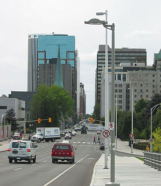
Rideau Street is a major street in downtown Ottawa, Ontario, Canada and one of Ottawa's oldest and most famous streets running from Wellington Street in the west to Montreal Road in the east where it connects to the Vanier district. Rideau Street is home to the Château Laurier, the CF Rideau Centre and the Government Conference Centre. Along with Wellington Street and Sussex Drive it was among the first streets in Ottawa to be host to businesses; it was created with the founding of the early town. The Plaza Bridge by the Rideau Canal is at its westmost point and the Cummings Bridge is at its eastmost point.

Sussex Drive, also known as Ottawa Regional Road 93, is an arterial road in Ottawa, Ontario, the capital of Canada. It is one of the city's main ceremonial and institutional routes. Travelling roughly parallel to the Ottawa River, Sussex Drive begins as a continuation of Sir George-Étienne Cartier Parkway at Rideau Gate, at the entrance to Rideau Hall. It travels south to Rideau Street, with the portion south of St. Patrick Street forming the northbound half of a one-way pair with Mackenzie Avenue. Both Mackenzie Avenue and Sussex Drive connect with Colonel By Drive at their southern end, which continues south alongside the Rideau Canal.

Ottawa Centre is an urban federal electoral district in Ontario, Canada, that has been represented in the House of Commons of Canada since 1968. While the riding's boundaries have changed over the years to account for population changes, the riding has always comprised the central areas of Ottawa, the nation's capital.
Laurier Avenue(French: Avenue Laurier) is a central east west street running through Ottawa, Ontario, Canada. Originally known as "Maria Street" and "Theodore Street", it was renamed in honour of Canadian Prime Minister Sir Wilfrid Laurier. Laurier House, the residence of Prime Ministers Laurier and William Lyon Mackenzie King, is located at the corner of Laurier Avenue East and Chapel Street.

The Senate of Canada Building is located at 2 Rideau Street in downtown Ottawa, Ontario, Canada and serves as the temporary seat of the Senate of Canada. The building served as Ottawa's central railway station from 1912 until 1966, and from 1966 to 2018 it was operated by the Government of Canada as the Government Conference Centre. The building currently includes a temporary Senate chamber, as well as some Senate offices and committee rooms.
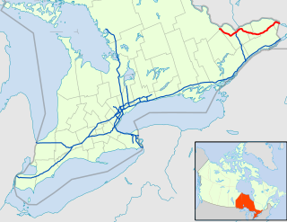
King's Highway 417, commonly referred to as Highway 417 and as the Queensway through Ottawa, is a 400-series highway in the Canadian province of Ontario. It connects Ottawa with Montreal via A-40, and is the backbone of the highway system in the National Capital Region. Within Ottawa, it forms part of the Queensway west from Highway 7 to Ottawa Road 174. Highway 417 extends from the Quebec border, near Hawkesbury, to Arnprior, where it continues westward as Highway 17. Aside from the urban section through Ottawa, Highway 417 passes through farmland that dominates much of the fertile Ottawa Valley.

Barrhaven is a suburb of Ottawa, Ontario, Canada. It is located about 17 km (11 mi) southwest of the city's downtown core. Prior to amalgamation with Ottawa in 2001, Barrhaven was part of the City of Nepean. Its population as of the Canada 2021 Census was 103,234.

Alta Vista Drive is a suburban road in Ottawa, Ontario, Canada. It runs from Bank Street in the south to Industrial Avenue in the north covering the neighbourhoods of Ridgemont, Alta Vista and Riverview.

Elgin Street is a street in the Downtown core of Ottawa, Ontario, Canada. Originally named Biddy's Lane, it was later named after Lord Elgin.
King's Highway 31, commonly referred to as Highway 31 and historically known as the Metcalfe Road, was a provincially maintained highway in the Canadian province of Ontario. The 76.93-kilometre (47.80 mi) route connected Highway 2 in Morrisburg with the Chaudière Bridge at the Ontario–Quebec boundary in downtown Ottawa.

Nicholas Street is an arterial road in the central area of Ottawa, Ontario which connects Highway 417 with the downtown core. Despite being a municipal road, the street is designated as part of Canada's National Highway System, as part of an interconnecting route between Highway 417 and Quebec Autoroute 5 in Gatineau.

Ottawa Road 174, formerly Ottawa-Carleton Regional Road 174 and commonly referred to as Highway 174, is a city-maintained road in the City of Ottawa which serves the eastern suburbs of Orléans and Cumberland. The four-lane freeway segment between Highway 417/Aviation Parkway junction to Trim Road is also known as the Queensway, in addition the Queensway name continues to be applied to Highway 417 west of that intersection. Although the road continues through the towns of Rockland and Hawkesbury to the Quebec border, the portion east of the Ottawa city boundary is known as Prescott and Russell County Road 17.

King Edward Avenue is a major thoroughfare in the eastern part of Ottawa, Ontario, Canada. Despite being a municipal road, a portion of the street is designated as part of Canada's National Highway System, as part of an interconnecting route between Ontario Highway 417 in Ottawa and Quebec Autoroute 5 in Gatineau.

The architecture of Ottawa is most marked by the city's role as the national capital of Canada. This gives the city a number of monumental structures designed to represent the federal government and the nation. It also means that as a city dominated by government bureaucrats, much of its architecture tends to be formalistic and functional. However, the city is also marked by Romantic and Picturesque styles of architecture such as the Parliament Building's Gothic Revival architecture.

Eastway Gardens is a small neighbourhood in Alta Vista Ward in the east end of Ottawa, Ontario, Canada. It consists of a series of dead end streets coming off of Tremblay Road between Riverside Drive and St. Laurent Boulevard. Most of these streets are named for letters of the alphabet, beginning with Avenue K and ending with Avenue U. According to the Canada 2016 Census, the neighbourhood had a population of 602. The residents association boundaries for the neighbourhood are the Rideau River to the west, St. Laurent Boulevard to the east, Coventry Road to the north, and Belfast Road to the south.