Related Research Articles

Kenmore Square is a square in Boston, Massachusetts, United States, consisting of the intersection of several main avenues as well as several other cross streets, and Kenmore station, an MBTA subway stop. Kenmore Square is close to or abuts Boston University and Fenway Park, and it features Lansdowne Street, a center of Boston nightlife, and the Citgo sign. It is also the eastern terminus of U.S. Route 20, the longest U.S. Highway.

Congress Street Grounds is a former baseball ground located in Boston, Massachusetts. The ballpark, as the name implies, was along Congress Street, near the intersection of Thompson Place, and not far from the Fort Point Channel on South Boston Flats, a newly filled in piece of land on Boston Harbor. The ground was home to the Boston Reds, that played in the Players' League in 1890 and the American Association in 1891.
Cleveland Circle, an area of Boston, Massachusetts, is located in Boston's Brighton neighborhood, and more specifically the Aberdeen section of Brighton, in very close proximity to Brookline and Chestnut Hill, Massachusetts, at the intersection of Beacon Street and Chestnut Hill Avenue.

The New England College of Optometry is a private optometry college in Boston, Massachusetts. It enrolls over 500 students and is one of the oldest continually operating college of optometry in the United States.
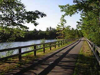
The Nashua River Rail Trail is a 12.5-mile (20.1 km) paved mixed-use rail trail in northern Massachusetts and southern New Hampshire under control of the Massachusetts Department of Conservation and Recreation (DCR). It roughly follows the course of the Nashua River, passing through the towns of Ayer, Groton, Pepperell, and Dunstable, Massachusetts and ends about a mile across the New Hampshire state border in Nashua, New Hampshire. The trail is used by walkers, cyclists, inline skaters, equestrians, and cross-country skiers.
Massachusetts Correctional Institution – Framingham is the Massachusetts Department of Correction's institution for female offenders. It is located in Framingham, Massachusetts, a city located midway between Worcester and Boston. The prison was once known as "Framingham State Prison". However, MCI Framingham is its official name and is favored. As of May 2022 there are approximately 190 inmates in general population beds.
The Boston Center for the Arts (BCA) is a 501(c) nonprofit visual and performing arts complex in the South End neighborhood of Boston, Massachusetts. The BCA houses several performance and rehearsal spaces, restaurants, a gallery, the headquarters of the Boston Ballet, the Community Music Center of Boston and several other arts organizations. The BCA also serves as home to four Resident Theater Companies and a number of artists. The BCA's main building, the Cyclorama, is on the National Register of Historic Places. Boston Ballet's headquarters was designed in 1991 by architect Graham Gund.

Shawmut Peninsula is the promontory of land on which Boston, Massachusetts was built. The peninsula, originally a mere 789 acres (3.19 km2) in area, more than doubled in size due to land reclamation efforts that were a feature of the history of Boston throughout the 19th century.

The Leather District is a neighborhood of Boston near South Street, between the Financial District and Chinatown. The Leather District is a tightly defined area bounded by Kneeland Street to the south, Essex Street to the north, Atlantic Avenue to the east and Lincoln Street to the west. It is so named due to the dominance of the leather industry in the late 19th century.
The Wood River is a river in the U.S. states of Connecticut and Rhode Island. It flows approximately 25 miles (40 km) and is a major tributary of the Pawcatuck River. There are 8 dams along the river's length.

North Point Park is an 8.5-acre (3.4 ha) park located along the north side of the Charles River in Cambridge, Massachusetts and Boston's West End, created as mitigation for the taking of planned parkland for the construction of the Big Dig.

Noddle's Island was historically one of the Boston Harbor Islands off Boston, Massachusetts. Most of the original land of Noddle's Island now makes up the southern part of the neighborhood of East Boston; it is now part of the mainland since the strait connecting Noddle's Island to Hog Island and that connecting Hog Island to the mainland city of Revere were filled in the early 20th century. The original contours of Noddle's Island were also greatly obscured by the 20th-century construction of Logan International Airport, which filled the tidal flats between Noddle's Island and Governor's, Bird, and Apple islands to its east. In some sources it is spelled "Noodle's Island".
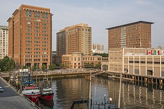
The Seaport Boston Hotel and World Trade Center is a hotel and conference center complex located on the South Boston Waterfront in Boston, Massachusetts. The South Boston Waterfront is also known as the Boston Seaport District and the Innovation District. The World Trade Center part of the complex is located on Commonwealth Pier.

The Chilton Club is a private social club established in 1910, in the Back Bay area of Boston, Massachusetts. Founded by Pauline Revere Thayer, the club was intended in part as a counterpoint to the Mayflower Club. The club was named after Mary Chilton because she had been the first woman to step out of the Mayflower.

Massachusetts Homeopathic Hospital was a homeopathic institution in Boston, Massachusetts, at which the first successful kidney removal in New England was performed. Established by an act of the Massachusetts legislature in 1855, the hospital opened its doors in 1871 at a site in Jamaica Plain. In 1874 it moved into a newly built facility in the South End of Boston. Over the next 30 years its facilities in that area were expanded, and in 1908 it opened a satellite facility in Brighton for the treatment of contagious diseases. The hospital eventually abandoned homeopathic practices, and in 1929 became part of Massachusetts Memorial Hospitals. This was eventually merged into the Boston University Medical Center, now part of Boston Medical Center. The hospital's main building survives, and is known as the Talbot Building; it now houses the Boston University School of Public Health.
In 1888 the directors of the Holyhood Cemetery Association purchased land in West Roxbury to develop St. Joseph Cemetery. At about 200 acres (81 ha), St. Joseph is one of the largest cemeteries in New England.

The South Boston Naval Annex, was a 167-acre (68 ha) United States Navy shipyard annex located in South Boston. It was the annex of the Boston Navy Yard, and was operational from the 1920 to 1974, when it was closed along with the main shipyard. The annex is also home to Dry Dock Number 3, one of the largest dry docks on the East Coast. Most of the former annex site was listed on the National Register of Historic Places in 2022.

The South Boston Army Base, previously the Boston Quartermaster Terminal or Army Supply Base and in 1937 named the Boston Army Base, was a 58-acre United States Army annex located in South Boston. It was authorized in April 1918 and opened for operation in October 1918. The terminal was part of the Boston sub-port of the New York Port of Embarkation during World War I. During World War II, it was a component of the Boston Port of Embarkation. It ceased operation in 1974.

Raymond L. Flynn Marine Park, formerly known as the Boston Marine Industrial Park, is an industrial park which has been created on the Commonwealth Flats in South Boston, Massachusetts, United States. Before its creation, the site was used as the location for the South Boston Naval Annex, the South Boston Army Base, and was used as a general seaport district for many years. Currently, the park is in the process of being redeveloped, and utilizes many of the former military buildings. The Black Falcon Cruise Terminal is located on the site of the former Army base.
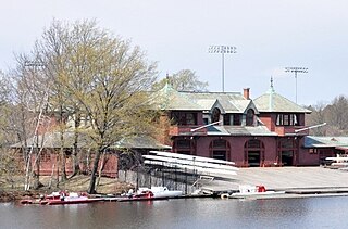
Newell Boathouse, named for a popular Harvard athlete killed just a few years after graduation, is the primary boathouse used by Harvard University's varsity men's rowing teams. It stands on land subject to an unusual peppercorn lease agreement between Harvard and the Commonwealth of Massachusetts.
References
- ↑ Seasholes, Nancy S. (29 August 2003). Gaining Ground: A History of Landmaking in Boston . Cambridge (Mas): The MIT Press. pp. 332–333. ISBN 0262194945 . Retrieved 25 November 2012.
commonwealth flats boston.
Coordinates: 42°20′55.46″N71°2′16.43″W / 42.3487389°N 71.0378972°W
| | This Massachusetts state location article is a stub. You can help Wikipedia by expanding it. |