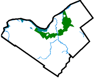
In urban planning in the United States, a community separator (or simply a separator) is a parcel of undeveloped land, sometimes in the form of open space, separating two or more urban areas under different municipal jurisdictions which has been designated to provide a permanent low-density area preserving the communal integrity of the two municipalities. Separators are typically created by one or more municipalities in situations of rapid urban growth, where unchecked development might otherwise result in the contiguity of the urban areas. A unilateral separator that partially or completely encircles a municipality is commonly known as a greenbelt.
Urban planning is a technical and political process concerned with the development and design of land use and the built environment, including air, water, and the infrastructure passing into and out of urban areas, such as transportation, communications, and distribution networks. Urban planning deals with physical layout of human settlements. The primary concern is the public welfare, which includes considerations of efficiency, sanitation, protection and use of the environment, as well as effects on social and economic activities. Urban planning is considered an interdisciplinary field that includes social, engineering and design sciences. It is closely related to the field of urban design and some urban planners provide designs for streets, parks, buildings and other urban areas. Urban planning is also referred to as urban and regional planning, regional planning, town planning, city planning, rural planning, urban development or some combination in various areas worldwide.
The United States of America (USA), commonly known as the United States or America, is a country composed of 50 states, a federal district, five major self-governing territories, and various possessions. At 3.8 million square miles, the United States is the world's third or fourth largest country by total area and is slightly smaller than the entire continent of Europe's 3.9 million square miles. With a population of over 327 million people, the U.S. is the third most populous country. The capital is Washington, D.C., and the largest city by population is New York City. Forty-eight states and the capital's federal district are contiguous in North America between Canada and Mexico. The State of Alaska is in the northwest corner of North America, bordered by Canada to the east and across the Bering Strait from Russia to the west. The State of Hawaii is an archipelago in the mid-Pacific Ocean. The U.S. territories are scattered about the Pacific Ocean and the Caribbean Sea, stretching across nine official time zones. The extremely diverse geography, climate, and wildlife of the United States make it one of the world's 17 megadiverse countries.
An urban area or urban agglomeration is a human settlement with high population density and infrastructure of built environment. Urban areas are created through urbanization and are categorized by urban morphology as cities, towns, conurbations or suburbs. In urbanism, the term contrasts to rural areas such as villages and hamlets and in urban sociology or urban anthropology it contrasts with natural environment. The creation of early predecessors of urban areas during the urban revolution led to the creation of human civilization with modern urban planning, which along with other human activities such as exploitation of natural resources leads to human impact on the environment.
Separators often consist of undeveloped farmland, forests, floodplains, or other areas that may or may not be desirable for residential or commercial development. The enactment of a separator is commonly achieved through a variety of different means, including conservation easements, outright purchase of land for parks, or zoning restrictions. Separators are often enacted along major highways connecting municipalities in order to preserve the open viewshed that provides a natural boundary between two communities.
Agriculture is the science and art of cultivating plants and livestock. Agriculture was the key development in the rise of sedentary human civilization, whereby farming of domesticated species created food surpluses that enabled people to live in cities. The history of agriculture began thousands of years ago. After gathering wild grains beginning at least 105,000 years ago, nascent farmers began to plant them around 11,500 years ago. Pigs, sheep and cattle were domesticated over 10,000 years ago. Plants were independently cultivated in at least 11 regions of the world. Industrial agriculture based on large-scale monoculture in the twentieth century came to dominate agricultural output, though about 2 billion people still depended on subsistence agriculture into the twenty-first.
A forest is a large area dominated by trees. Hundreds of more precise definitions of forest are used throughout the world, incorporating factors such as tree density, tree height, land use, legal standing and ecological function. According to the widely used Food and Agriculture Organization definition, forests covered 4 billion hectares (9.9×10⁹ acres) (15 million square miles) or approximately 30 percent of the world's land area in 2006.
A floodplain or flood plain is an area of land adjacent to a stream or river which stretches from the banks of its channel to the base of the enclosing valley walls, and which experiences flooding during periods of high discharge. The soils usually consist of levees, silts, and sands deposited during floods. Levees are the heaviest materials and they are deposited first; silts and sands are finer materials.
Separators are sometimes controversial since they can withdraw desirable development land from the marketplace, resulting not only in the loss of tax revenue but also incurring the cost of acquiring and managing the land.
An economic system is a system of production, resource allocation and distribution of goods and services within a society or a given geographic area. It includes the combination of the various institutions, agencies, entities, decision-making processes and patterns of consumption that comprise the economic structure of a given community. As such, an economic system is a type of social system. The mode of production is a related concept. All economic systems have three basic questions to ask: what to produce, how to produce and in what quantities and who receives the output of production.
A tax is a mandatory financial charge or some other type of levy imposed upon a taxpayer by a governmental organization in order to fund various public expenditures. A failure to pay, along with evasion of or resistance to taxation, is punishable by law. Taxes consist of direct or indirect taxes and may be paid in money or as its labour equivalent.
This United States–related article is a stub. You can help Wikipedia by expanding it.
This page is based on this Wikipedia article Text is available under the CC BY-SA 4.0 license; additional terms may apply. Images, videos and audio are available under their respective licenses.
Related Research Articles
Smart growth is an urban planning and transportation theory that concentrates growth in compact walkable urban centers to avoid sprawl. It also advocates compact, transit-oriented, walkable, bicycle-friendly land use, including neighborhood schools, complete streets, and mixed-use development with a range of housing choices. The term "smart growth" is particularly used in North America. In Europe and particularly the UK, the terms "compact city", "urban densification" or "urban intensification" have often been used to describe similar concepts, which have influenced government planning policies in the UK, the Netherlands and several other European countries.
An urban growth boundary, or UGB, is a regional boundary, set in an attempt to control urban sprawl by, in its simplest form, mandating that the area inside the boundary be used for urban development and the area outside be preserved in its natural state or used for agriculture. Legislating for an "urban growth boundary" is one way, among many others, of managing the major challenges posed by unplanned urban growth and the encroachment of cities upon agricultural and rural land.
A town is a human settlement. Towns are generally larger than villages but smaller than cities, though the criteria to distinguish them vary considerably between different parts of the world.
Zoning is the process of dividing land in a municipality into zones in which certain land uses are permitted or prohibited. In addition, the sizes, bulk, and placement of buildings may be regulated. The type of zone determines whether planning permission for a given development is granted. Zoning may specify a variety of outright and conditional uses of land. It may also indicate the size and dimensions of land area as well as the form and scale of buildings. These guidelines are set in order to guide urban growth and development.
A green belt or greenbelt is a policy and land use zone designation used in land use planning to retain areas of largely undeveloped, wild, or agricultural land surrounding or neighbouring urban areas. Similar concepts are greenways or green wedges which have a linear character and may run through an urban area instead of around it. In essence, a green belt is an invisible line designating a border around a certain area, preventing development of the area and allowing wildlife to return and be established.
Urban agriculture,urban farming, or urban gardening is the practice of cultivating, processing and distributing food in or around urban areas. Urban agriculture can also involve animal husbandry, aquaculture, agroforestry, urban bees, and horticulture. These activities occur in peri-urban areas as well, and peri-urban agriculture may have different characteristics.
A residential area is a land used in which housing predominates, as opposed to industrial and commercial areas.
Housing may vary significantly between, and through, residential areas. These include single-family housing, multi-family residential, or mobile homes. Zoning for residential use may permit some services or work opportunities or may totally exclude business and industry. It may permit high density land use or only permit low density uses. Residential zoning usually includes a smaller FAR than business, commercial or industrial/manufacturing zoning. The area may be large or small.
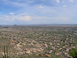
Urban sprawl or suburban sprawl mainly refers to the unrestricted growth in many urban areas of housing, commercial development, and roads over large expanses of land, with little concern for urban planning. In addition to describing a particular form of urbanization, the term also relates to the social and environmental consequences associated with this development. In Continental Europe the term "peri-urbanisation" is often used to denote similar dynamics and phenomena, although the term urban sprawl is currently being used by the European Environment Agency. There is widespread disagreement about what constitutes sprawl and how to quantify it. For example, some commentators measure sprawl only with the average number of residential units per acre in a given area. But others associate it with decentralization, discontinuity, segregation of uses, and so forth.
Impervious surfaces are mainly artificial structures—such as pavements that are covered by impenetrable materials such as asphalt, concrete, brick, stone—and rooftops. Soils compacted by urban development are also highly impervious.
Infill is the urban planning term for the rededication of land in an urban environment, usually open-space, to new construction. Infill also applies within an urban polity to construction on any undeveloped land that is not on the urban margin. The slightly broader term "land-recycling" is sometimes used instead. Infill has been promoted as an economical use of existing infrastructure and a remedy for urban sprawl. Its detractors view it as overloading urban services, including increased traffic congestion and pollution, and decreasing urban green-space.
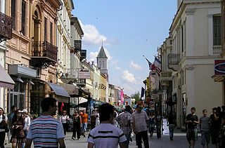
Mixed-use development or often simply Live-work space is a type of urban development strategy for living spaces (housing) that blends residential, commercial, cultural, institutional, or entertainment uses, where those functions are physically and functionally integrated, and that provides pedestrian connections. Mixed-use development can take the form of a single building, a city block, or entire neighbourhoods. The term may also be used more specifically to refer to a mixed-use real estate development project—a building, complex of buildings, or district of a town or city that is developed for mixed-use by a private developer, (quasi-) governmental agency, or a combination thereof.
The administrative divisions of Wisconsin include counties, cities, villages and towns. In Wisconsin, all of these are units of general-purpose local government. There are also a number of special-purpose districts formed to handle regional concerns, such as school districts.
Current use is a phrase used to describe the present condition of land use and corresponding scheme for property tax incentives for qualifying land owners who wish to preserve open space and avoid having their property assessed at the "best and highest" use that could be made of it. The statutes provide significant savings when the land is currently in use for farming, silviculture, or comprises wetlands, or even unproductive woods or barrens. Further discounts may accrue if the land owner is willing to file a recreational easement permitting the unimpeded public to come upon the land for non-motorized recreation. Some jurisdictions require a qualifying submittal of a "stewardship plan" for woodlands, while others provide further tax reductions for these optional inclusions. Soils data must often be included for requests related to agricultural areas.
Conservation development, also known as conservation design, is a controlled-growth land use development that adopts the principle for allowing limited sustainable development while protecting the area's natural environmental features in perpetuity, including preserving open space landscape and vista, protecting farmland or natural habitats for wildlife, and maintaining the character of rural communities. A conservation development is usually defined as a project that dedicates a minimum of 50 percent of the total development parcel as open space. The management and ownership of the land are often formed by the partnership between private land owners, land-use conservation organizations and local government. It is a growing trend in many parts of the country, particularly in the Western United States. In the Eastern United States, conservation design has been promoted by some state and local governments as a technique to help preserve water quality.
In real estate, a lot or plot is a tract or parcel of land owned or meant to be owned by some owner(s). A lot is essentially considered a parcel of real property in some countries or immovable property in other countries. Possible owner(s) of a lot can be one or more person(s) or another legal entity, such as a company/corporation, organization, government, or trust. A common form of ownership of a lot is called fee simple in some countries.
Development-supported agriculture
is a nascent movement in real estate development that preserves and invests in agricultural land use. As farmland is lost due to the challenging economics of farming and the pressures of the real estate industry, DSA attempts to reconcile the need for development with the need to preserve agricultural land. The overall goal of DSA is to incubate small-scale organic farms that co-exist with residential land development, providing benefits to farmers, residents, the local community, and the environment.
An open space reserve is an area of protected or conserved land or water on which development is indefinitely set aside.
An urban planner is a professional who practices in the field of urban planning.
Land recycling is the reuse of abandoned, vacant, or underused properties for redevelopment or repurposing.
The Town Planning Board is a statutory body of the Hong Kong Government tasked with developing urban plans with an aim to ensuring the "health, safety, convenience and general welfare of the community through the process of guiding and controlling the development and use of land, and to bring about a better organised, efficient and desirable place to live and work." It is founded upon section 2 of the Town Planning Ordinance.