
A geographic information system (GIS) is a type of database containing geographic data, combined with software tools for managing, analyzing, and visualizing those data. In a broader sense, one may consider such a system to also include human users and support staff, procedures and workflows, body of knowledge of relevant concepts and methods, and institutional organizations.

Short Message/Messaging Service, commonly abbreviated as SMS, is a text messaging service component of most telephone, Internet and mobile device systems. It uses standardized communication protocols that let mobile devices exchange short text messages. An intermediary service can facilitate a text-to-voice conversion to be sent to landlines.

A footpath is a type of thoroughfare that is intended for use only by pedestrians and not other forms of traffic such as motorized vehicles, bicycles and horses. They can be found in a wide variety of places, from the centre of cities, to farmland, to mountain ridges. Urban footpaths are usually paved, may have steps, and can be called alleys, lanes, steps, etc.
GPX, or GPS Exchange Format, is an XML schema designed as a common GPS data format for software applications. It can be used to describe waypoints, tracks, and routes. It is an open format and can be used without the need to pay license fees. Location data is stored in tags and can be interchanged between GPS devices and software. Common software applications for the data include viewing tracks projected onto various map sources, annotating maps, and geotagging photographs based on the time they were taken.
The IP Multimedia Subsystem or IP Multimedia Core Network Subsystem (IMS) is a standardised architectural framework for delivering IP multimedia services. Historically, mobile phones have provided voice call services over a circuit-switched-style network, rather than strictly over an IP packet-switched network. Alternative methods of delivering voice (VoIP) or other multimedia services have become available on smartphones, but they have not become standardized across the industry. IMS is an architectural framework that provides such standardization.

Google Maps is a web mapping platform and consumer application offered by Google. It offers satellite imagery, aerial photography, street maps, 360° interactive panoramic views of streets, real-time traffic conditions, and route planning for traveling by foot, car, bike, air and public transportation. As of 2020, Google Maps was being used by over 1 billion people every month around the world.
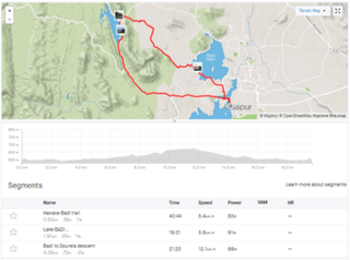
GPS Drawing, also known as GPS Art, is a method of drawing where an artist uses a Global Positioning System (GPS) device and follows a pre-planned route to create a large-scale picture or pattern. The .GPX data file recorded during the drawing process is then visualised, usually overlaying it as a line on a map of the area. Artists usually run or cycle the route—while cars, vans, boats and aeroplanes are utilized to create larger pieces.
Photobucket is an American image hosting and video hosting website, web services suite, and online community. Photobucket hosts more than 10 billion images from 100 million registered members. Photobucket's headquarters are in Denver, Colorado. The website was founded in 2003 by Alex Welch and Darren Crystal and received funding from Trinity Ventures. It was acquired by Fox Interactive Media in 2007. In December 2009, Fox's parent company, News Corp, sold Photobucket to Seattle mobile imaging startup Ontela. Ontela then renamed itself Photobucket Inc. and continues to operate as Photobucket.

Google Analytics is a web analytics service offered by Google that tracks and reports website traffic, currently as a platform inside the Google Marketing Platform brand. Google launched the service in November 2005 after acquiring Urchin.

Ovi by Nokia was the brand for Nokia's Internet services. The Ovi services could be used from a mobile device, computer or via the web. Nokia focused on five key service areas: Games, Maps, Media, Messaging and Music. Nokia's aim with Ovi was to include third party developers, such as operators and third-party services like Yahoo's Flickr photo site. With the announcement of Ovi Maps Player API, Nokia started to evolve their services into a platform, enabling third parties to make use of Nokia's Ovi services.

SharePoint is a web-based collaborative platform that integrates natively with Microsoft Office. Launched in 2001, SharePoint is primarily sold as a document management and storage system, but the product is highly configurable and its usage varies substantially among organizations.
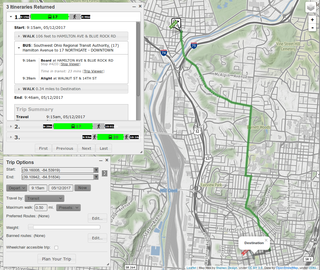
A journey planner, trip planner, or route planner is a specialized search engine used to find an optimal means of travelling between two or more given locations, sometimes using more than one transport mode. Searches may be optimized on different criteria, for example fastest, shortest, fewest changes, cheapest. They may be constrained, for example, to leave or arrive at a certain time, to avoid certain waypoints, etc. A single journey may use a sequence of several modes of transport, meaning the system may know about public transport services as well as transport networks for private transportation. Trip planning or journey planning is sometimes distinguished from route planning, which is typically thought of as using private modes of transportation such as cycling, driving, or walking, normally using a single mode at a time. Trip or journey planning, in contrast, would make use of at least one public transport mode which operates according to published schedules; given that public transport services only depart at specific times, an algorithm must therefore not only find a path to a destination, but seek to optimize it so as to minimize the waiting time incurred for each leg. In European Standards such as Transmodel, trip planning is used specifically to describe the planning of a route for a passenger, to avoid confusion with the completely separate process of planning the operational journeys to be made by public transport vehicles on which such trips are made.

HERE Technologies is an American-Dutch multinational group dealing with mapping, location data and related automotive services to individuals and companies. It is majority-owned by a consortium of German automotive companies and American semiconductor company Intel whilst other companies also own minority stakes. Its roots date back to U.S.-based Navteq in 1985, which was acquired by Finland-based Nokia in 2007. HERE is currently based in The Netherlands.

Internavi is a vehicle telematics service offered by the Honda Motor Company to drivers in Japan. In the United States, the service is known as HondaLink, or sometimes MyLink. It provides mobile connectivity for on-demand traffic information services and internet provided maps displayed inside selected Honda vehicles. The service began August 1997 and was first offered in the 1998 Honda Accord and the Honda Torneo sold only in Japan starting July 1998. The service received a revision to services offered October 2002, adding traffic information delivery capabilities for subscribers to the Internavi Premium Club, and was optional on most Honda vehicles sold in Japan. VICS was integrated into the service starting September 2003. Membership in the service has steadily grown to exceed 5 million subscribers as of March 2007.

Cycling infrastructure is all infrastructure cyclists are allowed to use. Bikeways include bike paths, bike lanes, cycle tracks, rail trails and, where permitted, sidewalks. Roads used by motorists are also cycling infrastructure, except where cyclists are barred such as many freeways/motorways. It includes amenities such as bike racks for parking, shelters, service centers and specialized traffic signs and signals. The more cycling infrastructure, the more people get about by bicycle.

CarWings, renamed NissanConnect in 2015, and also branded as Infiniti InTouch is a vehicle telematics service offered by the Nissan Motor Company to drivers in Japan, the United States, Canada, Great Britain, and most other countries where the LEAF is sold. It provides mobile connectivity for on-demand traffic information services and internet provided maps displayed inside select Nissan vehicles. The service began in December 1997, having been installed in the 1997 Nissan Cedric, Nissan Gloria, Nissan President, Nissan Cima and the Nissan Elgrand.

OsmAnd is a map and navigation app for Android and iOS. It uses the OpenStreetMap (OSM) map database for its primary displays, but is an independent app not endorsed by the OpenStreetMap Foundation. It is available in both free and paid versions; the latter unlocks the download limit for offline maps and provides access to Wikipedia points of interest (POIs) and their descriptions from within the app. Map data can be stored on the device for offline use. Using the device's GPS capabilities, OsmAnd offers routing, with visual and voice guidance, for car, bike, and pedestrian. All of the main functionalities work both online and offline.

Kinomap is a complete end-to-end platform for creating, hosting, sharing and using motion videos for user-generated videos. Kinomap allows uploading motion videos shot with a GPS camera or a common camera coupled with GPS track from another device. Kinomap platform contains geolocated video shooting, applications for Smartphone and tablets, data acquisition and integration, dedicated web portals and features like round-tour management, audio and video navigation, video tourism, indoor fitness training etc.
Strava is an American internet service for tracking physical exercise which incorporates social network features. It is mostly used for cycling and running using Global Positioning System data. Strava uses a freemium model with some features only available in the paid subscription plan. The service was founded in 2009 by Mark Gainey and Michael Horvath and is based in San Francisco, California.

Locus Map is a multi-functional Android navigation app adding advanced online and offline GPS capabilities to Android devices. Primarily it is designed and used for leisure time outdoor activities like hiking, biking, geocaching. Besides its leisure time utilization the app is also used by professionals e.g. for collecting geospatial data, by rescue squad teams, aerial reconnaissance teams etc.