
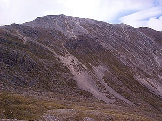
Beinn Dearg is the fourth highest of the Torridon Hills in the highlands of Scotland. Beinn Dearg offers all the typical features of a Torridon hill, with steeply terraced rocky sides dissected by near vertical gullies. The summit ridge is an airy crest that offers some easy scrambling; alternatively this can be avoided by following a path that traverses the terraces on the southern side.

Beinn Ìme is the highest mountain in the Arrochar Alps of Argyll, in the Southern Highlands of Scotland. It reaches 1,011 metres (3,317 ft), making it a Munro.
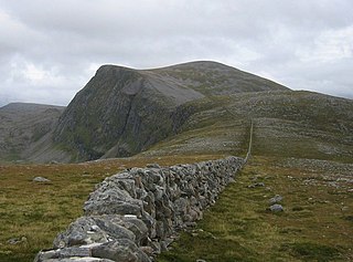
Beinn Dearg is a mountain in the Inverlael area of the Highlands of Scotland. It is most frequently climbed by following the River Lael up Gleann na Sguaib. Starting from near the head of Loch Broom, a path follows the glen to a bealach, which is about 1 kilometre (0.62 mi) north of the summit. From this bealach, the neighbouring peaks of Cona' Mheall and Meall na Ceapraichean may also be climbed. Eididh nan Clach Geala, which lies about 3 kilometres (1.9 mi) north of Beinn Dearg, is also added in to complete a round of four Munros.
Beinn Liath Mhòr is a Scottish mountain situated in the mountainous area between Strath Carron and Glen Torridon in Wester Ross in the Highland region. Geologically Beinn Liath Mhòr is made up of Cambrian quartzite scree and Torridonian sandstones giving the mountain a distinctive colour contrast of light and dark. The mountain's other main characteristic is its two kilometre long undulating summit ridge which does not drop below 800 metres for its entire length. This culminates at the summit at its far western end at a height of 926 metres (3038 feet) making Beinn Liath Mhòr the 258th highest Munro.

Sgorr Ruadh is a mountain between Strath Carron and Glen Torridon in Wester Ross in the Northwest Highlands of Scotland. It is located in Coire Lair near Achnashellach along with two other mountains, Beinn Liath Mhòr and Fuar Tholl, and is often climbed together with one or both of these other mountains.

Maol Cheann-Dearg is a mountain in the Northwest Highlands of Scotland, between Upper Loch Torridon and Loch Carron, in the Coulags deer forest in Wester Ross. It is one of three Munros in this area and reaches a height of 933 metres (3,060 feet), it is slightly isolated from the other two being separated by a low col of 420 metres and therefore tends to be ascended separately. The mountain is typical of the region in that geologically it is made up of a mixture of sandstone and quartzite, it has a steep flanks and is rock-strewn. The dome shaped summit is littered with red sandstone boulders and lacking in vegetation making its translated name of "red-headed brow" especially appropriate. The mountain is not to be confused with Maol Chinn-dearg, another Munro on the south Glen Shiel ridge.

Beinn Fhada or Ben Attow is a mountain in the Scottish Highlands.

Conival is a Scottish mountain situated in Assynt in the Sutherland area of the Highland Council Area, thirty kilometres north-northeast of Ullapool.

Chno Dearg is a mountain in the Lochaber area of the Scottish Highlands. It overlooks Glen Spean to the north and Loch Treig to the west. With a height of 1,046 metres (3,432 ft), it is classed as a Munro.

Beinn Bhuidhe is a mountain near the head of Loch Fyne in Argyll in the Scottish Highlands. It is a Munro with a height of 948 metres (3,110 ft).
Beinn Chabhair is a Scottish mountain. It has fine views down to Loch Lomond.

Beinn Dearg Mòr is a Corbett in the middle of the Fisherfield Forest, near Dundonnell and Northwest Highlands in Scotland. It rises to an elevation of 906 metres (2,972 ft) above sea level.

Beinn Dearg Bheag is a mountain in the Northwest Highlands, Scotland. It is located in the wild Dundonnell and Fisherfield Forest area of Wester Ross, a long way from any road or settlement.

Beinn Dearg is a mountain in the Grampian Mountains of Scotland. It lies north of the Perth and Kinross village of Blair Atholl, in the Forest of Atholl.

Beinn Enaiglair is a mountain in Wester Ross, Scotland. It lies in the Northwest Highlands.

Beinn na h-Eaglaise is a mountain in the Northwest Highlands of Scotland. It lies in Wester Ross, south of the village of Torridon.

Beinn Mheadhoin or Beinn Meadhain is a mountain in the Highlands of Scotland. It is a Munro with a height of 1,182 metres (3,878 ft) and by some counts it is the twelfth-highest mountain of Great Britain. It lies in the very heart of the Cairngorm mountains, and is one of the most remote in the region. Beinn Mheadoin is surrounded by deep glens and mountain lakes, including Loch A'an, Loch Etchachan and the Dubh Lochan.

Beinn Dearg Mhor, is a mountain in the Red Cuillin mountains of the Isle of Skye. It is located between Loch Ainort and the settlement of Sligachan.

Beinn nan Caorach is a mountain in the Northwest Highlands of Scotland, It is located near the village of Corran in Lochalsh.
Inverlael is a hamlet on the southern tip of Loch Broom in Ross-shire in the Highland council area in Scotland. It is located on the A835 main road 6 miles from Ullapool and 50 miles from Inverness. It is also atop the River Lael from where it gets its name.
