
Coney Island is a neighborhood and entertainment area in the southwestern section of the New York City borough of Brooklyn. The neighborhood is bounded by Brighton Beach to its east, Lower New York Bay to the south and west, and Gravesend to the north and includes the subsection of Sea Gate on its west. More broadly, the Coney Island peninsula consists of Coney Island proper, Brighton Beach, and Manhattan Beach. This was formerly the westernmost of the Outer Barrier islands on the southern shore of Long Island, but in the early 20th century it became connected to the rest of Long Island by land fill.

In the United States, trolley parks, which started in the 19th century, were picnic and recreation areas along or at the ends of streetcar lines in most of the larger cities. These were precursors to amusement parks. Trolley parks were often created by the streetcar companies to give people a reason to use their services on weekends.
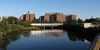
Coney Island Creek is a 1.8-mile-long (2.9 km) tidal inlet in Brooklyn, New York City. It was created from a series of streams and inlets by land filling and digging activities starting in the mid-18th century which, by the 19th century, became a 3-mile-long (4.8 km) continual strait and a partial mudflat connecting Gravesend Bay and Sheepshead Bay, separating Coney Island from the mainland. The strait was closed off in the early 20th century due to further land development and later construction projects. Today only the western half of Coney Island Creek exists. What once was a thriving fish and oyster population in salt marshes, freshwater streams, and expansive forests is now an unnatural environment wrecked by industrial pollution and construction debris. Urbanization of the city and man-made conditions have led to dumping of sewage and discarded materials, including cars and ship parts. Restoration projects are limited and most conservation efforts are seen to be performed by the local community.

The New York–New Jersey Harbor Estuary, also known as the Hudson-Raritan Estuary, is in the northeastern states of New Jersey and New York on the East Coast of the United States. The system of waterways of the Port of New York and New Jersey forms one of the most intricate natural harbors in the world and one of the busiest ports of the United States. The harbor opens onto the New York Bight in the Atlantic Ocean to the southeast and Long Island Sound to the northeast.
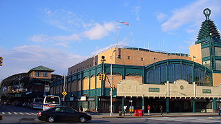
The Coney Island–Stillwell Avenue station is a terminal station of the New York City Subway in the Coney Island neighborhood of Brooklyn. It is the railroad-south terminus for the D, F, N, and Q trains at all times and for the <F> train during rush hours in the peak direction.
Coney Island is a neighborhood, visitor attraction, and former island in Brooklyn, New York.
Coney Island was a seasonal amusement park and water park destination on the banks of the Ohio River in Cincinnati, Ohio, located approximately 10 miles (16 km) east of the downtown area adjacent to Riverbend Music Center. One of its signature attractions, the Sunlite Pool, was the largest recirculating pool in North America and one of the largest of its kind in the world. Coney Island first opened as a picnic grove in 1870, and by the turn of the century, the park had added a lineup of popular amusement rides and significantly increased in size.

Community boards of Brooklyn are New York City community boards in the borough of Brooklyn, which are the appointed advisory groups of the community districts that advise on land use and zoning, participate in the city budget process, and address service delivery in their district.

The B68 is a bus route that constitutes a public transit line operating in Brooklyn, New York City. The B68 is operated by the MTA New York City Transit Authority. Its precursor was a streetcar line that began operation in June 1862, and was known as the Coney Island Avenue Line. The route became a bus line in 1955.
The Culver Line, Gravesend Avenue Line, or McDonald Avenue Line was a surface public transit line in Brooklyn, New York City, United States, running along McDonald Avenue and built by the Prospect Park and Coney Island Railroad. Most of its main line has been essentially replaced by the IND Culver Line of the New York City Subway.

Coney Island Light is a lighthouse located in Sea Gate, on the west end of Coney Island, Brooklyn, in New York City, east of New York Harbor's main channel.

The Riegelmann Boardwalk is a 2.7-mile-long (4.3 km) boardwalk on the southern shore of the Coney Island peninsula in Brooklyn, New York City, United States. Opened in 1923, the boardwalk runs along the Atlantic Ocean between West 37th Street to the west, at the edge of the Sea Gate neighborhood, and Brighton 15th Street to the east, in Brighton Beach. It is operated by the New York City Department of Parks and Recreation.
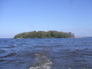
Coney Island is an island in Lough Neagh, Northern Ireland. It is about 1 km offshore from Maghery in County Armagh, is thickly wooded and of nearly 9 acres (36,000 m2) in area. It lies between the mouths of the River Blackwater and the River Bann in the south-west corner of Lough Neagh. Boat trips to the island are available at weekends from Maghery Country Park or Kinnego Marina. The island is owned by the National Trust and managed on their behalf by Armagh City, Banbridge and Craigavon Borough Council. Coney Island Flat is a rocky outcrop adjacent to the island. Although Samuel Lewis called Coney Island the only island in County Armagh, Armagh's section of Lough Neagh also includes Croaghan Island, as well as the marginal cases of Padian and Derrywarragh Island.

Luna Park is an amusement park in Coney Island, Brooklyn, New York City. It opened on May 29, 2010, at the site of Astroland, an amusement park that had been in operation from 1962 to 2008, and Dreamland, which operated at the same site for the 2009 season. It was named after the original 1903 Luna Park which operated until 1944 on a site just north of the current park's 1000 Surf Avenue location.
Vernon Keenan (1886–1964) was an American roller coaster designer best known for his involvement with the Cyclone at Coney Island.
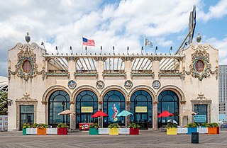
The Childs Restaurant Building on the Boardwalk is a New York City designated landmark on the Riegelmann Boardwalk at West 21st Street in Coney Island, Brooklyn, New York City. It was completed in 1923 for Childs Restaurants, an early restaurant chain and one of the largest in the United States at that time. It was designed in a "resort style with Spanish Revival influence" with colorful exterior terra cotta ornamentation that references its seaside location, with depictions of Poseidon, sailing ships, and sea creatures. It was a very large restaurant, with three stories and a roof garden.

Fort George Amusement Park was a trolley park and amusement park that operated in the Washington Heights and Inwood neighborhoods of Upper Manhattan, New York City, in the late 19th and early 20th centuries. It occupied an area between 190th and 192nd Streets east of Amsterdam Avenue, within present-day Highbridge Park.


