Congo Canyon
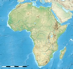
Location near Africa

Congo Canyon is a submarine canyon found at the end of the Congo River in Africa. It is one of the largest submarine canyons in the world. [1]
Congo Canyon is a submarine canyon found at the end of the Congo River in Africa. It is one of the largest submarine canyons in the world. [1]
The canyon begins inland on the continent, partway up the Congo Estuary, and starts at a depth of 21 meters. It cuts across the entire continental shelf for 85 kilometers until it reaches the shelf edge, then continues down the slope and ends 280 km from where it started. At its deepest point, the V-shaped canyon walls are 1,100 meters tall, and the maximum width of the canyon is about 9 miles (14 km). [2] At the bottom of the continental slope, it enters the Congo deep-sea fan and extends for an additional 220 km.

The turbidity currents found in Congo Canyon are the strongest measured in the world. [3] These are essentially underwater avalanches that can propagate for hundreds of kilometers, and their strength and frequency correlate strongly with the period of highest outflow from the Congo River. Their speeds vary from about 0.7 m/s to 3.5 m/s and events can last for more than a week. [4] These currents are the major source of erosion in the canyon and represent a significant portion of the sediment that ends up in the fan at the end of the canyon. They commonly destroy equipment laid on the bottom of the ocean and have destroyed telegraph cables and moorings. [1]
The Congo Deep-Sea Fan accounts for a surface of about 300,000 km2 and at least 0.7 Mkm3 of Cenozoic sediments, becoming one of the largest submarine fan systems in the world. [5] The fan extends over 1000 km from the Congo-Angola coast and was developed after the early Cretaceous rifting. The sediments includes quartz grains. [6]
The connection through the Congo submarine canyon allowed the direct transfer of terrestrial materials to the abyssal zone of the fan system. [6] Unlike other rivers that empty into the sea, the Congo River is not building a delta because essentially all of its sediments are carried by turbidity currents via the submarine canyon to the fan. This accumulation is probably the greatest in the world for a currently active submarine system. [7] The fan is built up by sediment gravity flows and other submarine mass movements, but also represents a very large active turbidite system. Although there exists a net up-canyon bottom current due to upwelling, [8] these events overwhelm the normal bottom flow and ensure continued deposition.

A continental shelf is a portion of a continent that is submerged under an area of relatively shallow water, known as a shelf sea. Much of these shelves were exposed by drops in sea level during glacial periods. The shelf surrounding an island is known as an insular shelf.

Xenophyophorea is a clade of foraminiferans. Xenophyophores are multinucleate unicellular organisms found on the ocean floor throughout the world's oceans, at depths of 500 to 10,600 metres. They are a kind of foraminiferan that extract minerals from their surroundings and use them to form an exoskeleton known as a test.

A submarine canyon is a steep-sided valley cut into the seabed of the continental slope, sometimes extending well onto the continental shelf, having nearly vertical walls, and occasionally having canyon wall heights of up to 5 km (3 mi), from canyon floor to canyon rim, as with the Great Bahama Canyon. Just as above-sea-level canyons serve as channels for the flow of water across land, submarine canyons serve as channels for the flow of turbidity currents across the seafloor. Turbidity currents are flows of dense, sediment laden waters that are supplied by rivers, or generated on the seabed by storms, submarine landslides, earthquakes, and other soil disturbances. Turbidity currents travel down slope at great speed, eroding the continental slope and finally depositing sediment onto the abyssal plain, where the particles settle out.

A turbidity current is most typically an underwater current of usually rapidly moving, sediment-laden water moving down a slope; although current research (2018) indicates that water-saturated sediment may be the primary actor in the process. Turbidity currents can also occur in other fluids besides water.
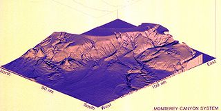
Monterey Canyon, or Monterey Submarine Canyon, is a submarine canyon in Monterey Bay, California with steep canyon walls measuring a full 1 mile (1.6 km) in height from bottom to top, which height/depth rivals the depth of the Grand Canyon itself. It is the largest such submarine canyon along the West coast of the North American continent, and was formed by the underwater erosion process known as turbidity current erosion. Many questions remain unresolved regarding the exact nature of its origins, and as such it is the subject of several ongoing geological and marine life studies being carried out by scientists stationed at the nearby Monterey Bay Aquarium Research Institute, the Moss Landing Marine Laboratories, and other oceanographic institutions.
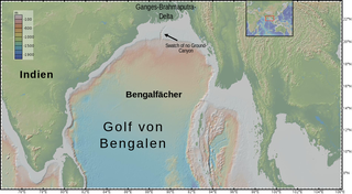
The Bengal Fan, also known as the Ganges Fan, is the largest submarine fan on Earth.

A passive margin is the transition between oceanic and continental lithosphere that is not an active plate margin. A passive margin forms by sedimentation above an ancient rift, now marked by transitional lithosphere. Continental rifting forms new ocean basins. Eventually the continental rift forms a mid-ocean ridge and the locus of extension moves away from the continent-ocean boundary. The transition between the continental and oceanic lithosphere that was originally formed by rifting is known as a passive margin.
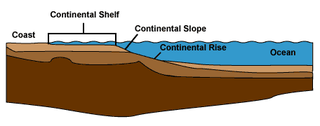
A continental margin is the outer edge of continental crust abutting oceanic crust under coastal waters. It is one of the three major zones of the ocean floor, the other two being deep-ocean basins and mid-ocean ridges. The continental margin consists of three different features: the continental rise, the continental slope, and the continental shelf. The continental shelf is the relatively shallow water area found in proximity to continents. Continental margins constitute about 28% of the oceanic area.

Abyssal fans, also known as deep-sea fans, underwater deltas, and submarine fans, are underwater geological structures associated with large-scale sediment deposition and formed by turbidity currents. They can be thought of as an underwater version of alluvial fans and can vary dramatically in size, with widths from several kilometres to several thousands of kilometres. The largest is the Bengal Fan, followed by the Indus Fan, but major fans are also found at the outlet of the Amazon, Congo, Mississippi and elsewhere.
A subsurface ocean current is an oceanic current that runs beneath surface currents. Examples include the Equatorial Undercurrents of the Pacific, Atlantic, and Indian Oceans, the California Undercurrent, and the Agulhas Undercurrent, the deep thermohaline circulation in the Atlantic, and bottom gravity currents near Antarctica. The forcing mechanisms vary for these different types of subsurface currents.

The Torlesse Composite Terrane is a plate tectonic terrane forming part of the South Island of New Zealand. It contains the Rakaia, Aspiring and Pahau Terranes and the Esk Head Belt. Greywacke is the dominant rock type of the composite terrane; argillite is less common and there are minor basalt occurrences. The Torlesse Composite Terrane is found east of the Alpine Fault in the Southern Alps of New Zealand. Its southern extent is a cryptic boundary with the Caples Terrane within the Haast Schists in Central Otago. It is named for the Torlesse Range in Canterbury.

Submarine landslides are marine landslides that transport sediment across the continental shelf and into the deep ocean. A submarine landslide is initiated when the downwards driving stress exceeds the resisting stress of the seafloor slope material, causing movements along one or more concave to planar rupture surfaces. Submarine landslides take place in a variety of different settings, including planes as low as 1°, and can cause significant damage to both life and property. Recent advances have been made in understanding the nature and processes of submarine landslides through the use of sidescan sonar and other seafloor mapping technology.
Syringammina is a xenophyophore found off the coast of Scotland, near Rockall. It is one of the largest single-celled organisms known, at up to 20 centimetres (8 in) across. It was first described in 1882 by the oceanographer John Murray, after being discovered on an expedition in the ship Triton which dredged the deep ocean bed off the west coast of Scotland in an effort to find organisms new to science. It was the first xenophyophore to be described and at first its relationship with other organisms was a mystery, but it is now considered to be a member of the Foraminifera.

Tentaoculus granulatus is a species of sea snail, deep-sea limpet, a marine gastropod mollusk in the family Pseudococculinidae.
The benthic boundary layer (BBL) is the layer of water directly above the sediment at the bottom of a body of water. Through specific sedimentation processes, certain organisms are able to live in this deep layer of water. The BBL is generated by the friction of the water moving over the surface of the substrate, which decrease the water current significantly in this layer. The thickness of this zone is determined by many factors, including the Coriolis force. The benthic organisms and processes in this boundary layer echo the water column above them.

The Northwest Atlantic Mid-Ocean Channel (NAMOC) is the main body of a turbidity current system of channels and canyons running on the sea bottom from the Hudson Strait, through the Labrador Sea, and ending at the Sohm Abyssal Plain in the Atlantic Ocean. Contrary to most other such systems which fan away from the main channel, numerous tributaries run into the NAMOC and end there. The density of those tributaries is the highest near the Labrador Peninsula, but the longest tributary, called Imarssuak Mid-Ocean Channel (IMOC), originates in the Atlantic Ocean.
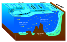
Circumpolar Deep Water (CDW) is a designation given to the water mass in the Pacific and Indian oceans that is a mixing of other water masses in the region. It is characteristically warmer and saltier than the surrounding water masses, causing CDW to contribute to the melting of ice shelves in the Antarctic region.
The Angola Basin is located along the West African South Atlantic Margin which extends from Cameroon to Angola. It is characterized as a passive margin that began spreading in the south and then continued upwards throughout the basin. This basin formed during the initial breakup of the supercontinent Pangaea during the early Cretaceous, creating the Atlantic Ocean and causing the formation of the Angola, Cape, and Argentine basins. It is often separated into two units: the Lower Congo Basin, which lies in the northern region and the Kwanza Basin which is in the southern part of the Angola margin. The Angola Basin is famous for its "Aptian Salt Basins," a thick layer of evaporites that has influenced topography of the basin since its deposition and acts as an important petroleum reservoir.
Cascadia Channel is the most extensive deep-sea channel currently known of the Pacific Ocean. It extends across Cascadia Abyssal Plain, through the Blanco Fracture Zone, and into Tufts Abyssal Plain. Notably, Cascadia Channel has tributaries, akin to river tributaries.
Cyclic steps are rhythmic bedforms associated with Froude super-critical flow instability. They are a type of sediment wave, and are created when supercritical sediment-laden water travels downslope through sediment beds. Each ‘step’ has a steep drop, and together they tend to migrate upstream. On the ocean floor, this phenomenon was first shown to be possible in 2006, although it was observed in open-channel flows over a decade earlier. Geological features appearing to be submarine cyclic steps have been detected in the northern lowlands of Mars in the Aeolis Mensae region, providing evidence of an ancient Martian ocean.