Related Research Articles

A bascule bridge is a moveable bridge with a counterweight that continuously balances a span, or leaf, throughout its upward swing to provide clearance for boat traffic. It may be single- or double-leafed.

A moveable bridge, or movable bridge, is a bridge that moves to allow passage for boats or barges. In American English, the term is synonymous with drawbridge, and the latter is the common term, but drawbridge can be limited to the narrower, historical definition used in some other forms of English, in which drawbridge refers to only a specific type of moveable bridge often found in castles.
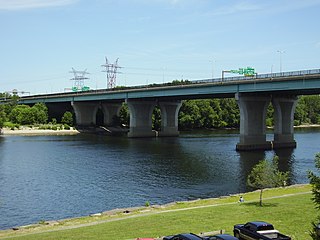
The Charter Oak Bridge is one of the three highway bridges over the Connecticut River between Hartford, Connecticut and East Hartford, Connecticut. The twin steel stringer bridge carries the Wilbur Cross Highway over the river.

The history of Bridgeport, Connecticut was, in the late 17th and most of the 18th century, one of land acquisitions from the native inhabitants, farming and fishing. From the mid-18th century to the mid-19th century, Bridgeport's history was one of shipbuilding, whaling and rapid growth. Bridgeport's growth accelerated even further from the mid-19th century to the mid-20th century with the advent of the railroad, Industrialization, massive immigration, labor movements until, at its peak population in 1950, Bridgeport with some 159,000 people was Connecticut's second most populous city. In the late 20th century, Bridgeport's history was one of deindustrialization and declining population, though it overtook Hartford as the state's most populous city by 1980.

The Pearl Harbor Memorial Bridge, commonly referred to as the Q Bridge by locals, is an extradosed bridge that carries Interstate 95 over the mouth of the Quinnipiac River in New Haven, in the U.S. state of Connecticut. This bridge replaced the original 1,300 m (0.8 mi) span which opened on January 2, 1958. The old bridge had a girder and floorbeam design where steel beams supported a concrete bridge deck that carried three lanes of traffic in each direction with no inside or outside shoulders. The bridge was officially dedicated as the Pearl Harbor Memorial Bridge in 1995 to commemorate the attack on Pearl Harbor.

The East Haddam Swing Bridge is a steel, movable (swing) truss bridge. The bridge is composed of three spans crossing the Connecticut River between Haddam, Connecticut and East Haddam, Connecticut. The bridge carries Route 82, with an average daily traffic of 11,600. At the time of its construction, it was reputed to be the longest swing bridge of its kind in the world.

The Lafayette Avenue Bridge, formerly listed on the National Register of Historic Places as the Bay City Bascule Bridge, is the name given to two separate bridges located in Bay City, Michigan. The bridges carry M-13 and M-84 over the Saginaw River. They are maintained by the Michigan Department of Transportation, and the bascule portion is currently the oldest of Bay City's four modern drawbridges. It was listed on the National Register of Historic Places on November 30, 1999, but was removed from the Register in 2015.
Bridgeport is the most populous city in the U.S. state of Connecticut and the fifth-most populous city in New England, with a population of 148,654 in 2020. Located in eastern Fairfield County at the mouth of the Pequonnock River on Long Island Sound, it is a port city 60 miles (97 km) from Manhattan and 40 miles (64 km) from The Bronx. It borders the towns of Trumbull to the north, Fairfield to the west, and Stratford to the east. Bridgeport and other towns in Fairfield County make up the Greater Bridgeport Planning Region, as well as the Bridgeport–Stamford–Norwalk–Danbury metropolitan statistical area, the second largest metropolitan area in Connecticut. The Bridgeport–Stamford–Norwalk–Danbury metropolis forms part of the New York metropolitan area.

The Amtrak Old Saybrook–Old Lyme Bridge is a railroad bridge that carries the Northeast Corridor over the Connecticut River between Old Saybrook and Old Lyme, Connecticut. It is the southernmost crossing of the river before it reaches Long Island Sound. The bridge is a truss bridge with a bascule span, allowing boat traffic to pass through. The bridge is owned by Amtrak; it is used by Amtrak Northeast Regional and Acela intercity trains, Shore Line East local trains, and Providence and Worcester Railroad freight trains. A $1.3 billion replacement bridge began construction in 2024 with completion scheduled for 2031.

The Pequonnock River is a 16.7-mile-long (26.9 km) waterway in eastern Fairfield County, Connecticut. Its watershed is located in five communities, with the majority of it located within Monroe, Trumbull, and Bridgeport. The river has a penchant for flooding, particularly in spring since the removal of a retention dam in Trumbull in the 1950s. There seems to be a sharp difference of opinion among historians as to just what the Indian word Pequonnock signifies. Some insist it meant cleared field or open ground; others are sure it meant broken ground; while a third group is certain it meant place of slaughter or place of destruction.
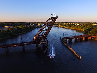
The Crook Point Bascule Bridge is a defunct Scherzer rolling lift railway bridge which spans the Seekonk River, connecting the city of Providence, Rhode Island, to the city of East Providence. Stuck in the open position since its abandonment in 1976, it is known to nearby residents as the "Stuck-Up Bridge" and has become somewhat of a local icon of urban decay. In 2022, the Providence Journal described the bridge as "a T-shirt-ready symbol of Providence's quirky evolution from industrial to creative hub."
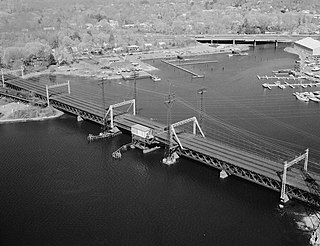
The Mianus River Railroad Bridge, also known as the Cos Cob Bridge, is a bascule drawbridge built in 1904 over the Mianus River, in Greenwich, Connecticut. It was listed on the National Register of Historic Places in 1987. The bridge carries the Northeast Corridor, the busiest rail line in the United States, both in terms of ridership and service frequency. It is operated by the Metro-North Railroad, successor to Conrail, Penn Central, and the New York, New Haven and Hartford Railroad, which erected it, and is owned by the Connecticut Department of Transportation.
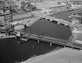
The Pequonnock River Railroad Bridge is a railroad drawbridge over the Pequonnock River in Bridgeport, Connecticut. Owned by the State of Connecticut and maintained and operated by both Amtrak and Metro-North Railroad, it is also referred to as Pequonnock River Bridge, PECK Bridge, and Undergrade Bridge 55.90. Currently the bridge is part of the Northeast Corridor line, carrying rail traffic of Amtrak and Metro-North, as well as freight trains operated by the Providence & Worcester Railroad.

Niantic River Bridge, also known as Amtrak Bascule Bridge No. 116.74, is a railroad bridge carrying Amtrak's Northeast Corridor line across the Niantic River between East Lyme and Waterford, Connecticut. It is a drawbridge with a bascule-type draw span. A new bridge was constructed in 2012 to replace the former span built in 1907. It opened on September 8, 2012. Related construction work finished in June 2013.
The Pleasure Beach Bridge is a movable Warren through-truss bridge in Bridgeport, Connecticut. Completed in 1927, it functioned as a toll bridge until the Great Depression, when it was transferred to the city of Bridgeport. Its service life came to an end after it was badly damaged by fire in 1996, cutting off access to Pleasure Beach. In the decade following the fire, several bonds to fund a new bridge were proposed, but ultimately fell through. Pleasure Beach has become the subject of debate, whether it will become an undisturbed protected salt marsh or be revitalized. An alternate method of access via water taxi service, first made possible by a grant in 2009, was not realized until 2013.

The East Washington Avenue Bridge refers to the bridges that have connected East Washington Avenue over the Pequonnock River in Bridgeport, Connecticut. Records state that a bridge was first constructed on the site in 1836, but no description of the bridge has been found. The second bridge was a truss swing design and underwent heavy repair and modernization in 1893. The third design was a movable Strauss underneath-counter weight deck-girder bascule bridge. The plans were drafted by James A. McElroy, using Joseph B. Strauss's design in 1916. However, construction was delayed for years because of a dispute with the contractor and a lack of funds. The bridge was completed by Bridgeport Dry Dock and Dredging when the State of Connecticut appropriated $350,000 to erect the bridge. Completed in 1925, the bridge underwent several modifications throughout its service life. On July 26, 1983, the bridge was closed after it was found to be in danger of collapse. It reopened after repair, but was closed in the 1990s before being replaced with a modern bascule bridge in 1998. In 2010, the report listed the deck and superstructure conditions as "Good" and the substructure condition as "Satisfactory".

The Grand Street Bridge was a double-leaf deck-girder bascule bridge in Bridgeport, Connecticut, United States, that spanned the Pequonnock River and connected Grand Street and Artic Street. It was one of three movable bridges planned by the City of Bridgeport in 1916 at the request of the War Department during World War I. Construction was completed in 1919, but the delays surrounding the construction went to the Connecticut Supreme Court in case of Edward DeV. Tompkins, Inc. vs. City of Bridgeport, Connecticut. The court ruled in favor of Tompkins and awarded damages equal to the contract. In 1936, the bridge had excessive settling and required the replacement of its southeast pier. As part of the repairs, a new floor and electrical system were installed. In 1965, the floor was replaced with a steel grate on I-beam floor. In 1984, the eastern approach span was replaced and the northwest trunnion post was reconstructed. The bridge was closed in the 1990s and dismantled in 1999.
Barnum station is a planned regional rail station to be located on the Metro-North Railroad's New Haven Line in East Bridgeport, Connecticut. The station will be named after the circus showman and former Bridgeport mayor P. T. Barnum, and will be located on the south side of Barnum Avenue between Seaview Avenue and Pembroke Street. A feasibility study was released in July 2013, followed by preliminary planning funding in July 2014 and an application for planning funding in June 2015. By January 2017, the station was planned to open in 2021. However, the project was indefinitely postponed in January 2019.
References
- 1 2 3 4 5 6 7 8 9 10 Clouette, Bruce (2004). Where Water Meets Land: Historic Movable Bridges of Connecticut. Connecticute Department of Transportation.
- ↑ "New Bridge in Bridgeport". Hartford Courant. 29 December 1908. ProQuest 555604258.
- ↑ Waldo, George Curtis (Jr.) (1917). History of Bridgeport and Vicinity, Volume 1. S. J. Clarke Publishing. p. 283.
- 1 2 3 4 5 6 7 8 Holtz, Jeff (19 May 2002). "City of Bridges Weighs Repairing Two of Them". The New York Times. ProQuest 432080082.
- 1 2 "Congress Street Bridge Demolition Begins This Week". Himes.House.gov. 8 March 2010. Archived from the original on 1 February 2014. Retrieved 24 January 2014.
- 1 2 3 4 John Burgeson and Keila Torres (10 March 2010). "Congress Street bridge demolition starts, but replacement uncertain". CT Post. Retrieved 24 January 2014.
- ↑ "Drawbridge Operation Regulation; Pequonnock River, Bridgeport, CT". Federal Register. 13 September 2010. Retrieved 17 March 2014.
- ↑ "Stratford Avenue bridge out of service". Bridgeport News. 23 July 2013. Archived from the original on 19 February 2014. Retrieved 24 January 2014.
- ↑ "Memo to Congress: Best Investments are in Cities: Economic Stimulus". Hartford Courant. 21 December 2008. ProQuest 257180061.