The Arctic Archipelago, also known as the Canadian Arctic Archipelago, is an archipelago lying to the north of the Canadian continental mainland, excluding Greenland.
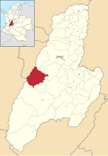
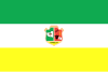
Roncesvalles is a municipality in the Tolima department of Colombia. The population of the municipality was 7,647 as of the 1993 census.

The Prince Charles Mountains are a major group of mountains in Mac. Robertson Land in Antarctica, including the Athos Range, the Porthos Range, and the Aramis Range. The highest peak is Mount Menzies, with a height of 3,228 m (10,591 ft). Other prominent peaks are Mount Izabelle and Mount Stinear. These mountains, together with other scattered peaks, form an arc about 420 km (260 mi) long, extending from the vicinity of Mount Starlight in the north to Goodspeed Nunataks in the south.
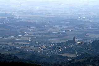
Dicastillo is a town and municipality located in the province and autonomous community of Navarre, northern Spain. Dicastillo is a village in Navarra. It is near Estella.

Lawrie Glacier is a glacier flowing between Mount Genecand and Mezzo Buttress, and entering the head of Barilari Bay between Cherkovna Point and Prestoy Point on the west coast of Graham Land, Antarctica. It was charted by the British Graham Land Expedition under Rymill, 1934–37, and was named by the UK Antarctic Place-Names Committee in 1959 for Robert Lawrie, an English alpine and polar equipment specialist.

Ardvi is a village in the Lori Province of Armenia.
Nahapetavan is a village in the Shirak Province of Armenia. The town was renamed in 1961 in honor of Nagapet Kurghinian (1900-1937), a participant in the Bolshevik uprising in May 1920.
Abasbəyli is a village and municipality in the Masally Rayon of Azerbaijan. It has a population of 658.
Belo Polje is a village in the municipality of Gornji Milanovac, Serbia. According to the 2002 census, the village has a population of 256 people.

Bilgeri Glacier is a glacier flowing into Barilari Bay south of Huitfeldt Point and west of Byaga Point, on Velingrad Peninsula on the west coast of Graham Land in Antarctica. It was charted by the British Graham Land Expedition under John Rymill, 1934–37, and named by the UK Antarctic Place-Names Committee in 1959 for Georg Bilgeri (1873–1934), Austrian pioneer exponent of skiing, inventor of the first spring ski binding, and author of one of the earliest skiing manuals.

Bussey Glacier is a glacier flowing west from Mount Peary to the head of Waddington Bay on Kyiv Peninsula on the west coast of Graham Land. It was first charted by the French Antarctic Expedition under Jean-Baptiste Charcot, 1908–10, and named by the UK Antarctic Place-Names Committee in 1959 for Group Captain John Bussey of the Directorate of Overseas Surveys.
Donnachie Cliff is a cliff on Ulu Peninsula, James Ross Island, rising to about 500 metres (1,600 ft) northeast of Back Mesa. Following geological work by the British Antarctic Survey, 1985–86, it was named by the UK Antarctic Place-Names Committee after Thomas Donnachie, a radio operator on Operation Tabarin at Hope Bay, 1944–45.

Pyke Glacier is a glacier 5 nautical miles (9 km) long, flowing southward from Detroit Plateau, between Albone and Polaris Glaciers on Nordenskjöld Coast in northern Graham Land, Antarctica. Mapped from surveys by Falkland Islands Dependencies Survey (FIDS) (1960–61). Named by United Kingdom Antarctic Place-Names Committee (UK-APC) for Geoffrey N. Pyke (1894–1948), English scientist who in 1941 originated the ideas developed by the Studebaker Corporation into the M-29 Tracked Cargo Carrier or "Weasel," the first really successful snow vehicle.
Temple Glacier is a glacier flowing into the south side of Lanchester Bay on the west coast of Graham Land. Photographed by Hunting Aerosurveys Ltd. in 1955-57 and mapped from these photos by the Falkland Islands Dependencies Survey (FIDS). Named by the United Kingdom Antarctic Place-Names Committee (UK-APC) in 1960 for Félix du Temple de la Croix (1823–1890), French naval officer who in 1857 designed the first powered model airplane to rise unaided, fly freely and land safely.
Tawny Gap is a low pass extending across South Georgia from the head of Ice Fjord to a cove just south of Wales Head. The name was given by the United Kingdom Antarctic Place-Names Committee (UK-APC) following survey by the SGS in the period 1951-57 and is descriptive of the colorful vegetation in this small gap.
Roe Glacier is a tributary glacier, 10 nautical miles (18 km) long, flowing northwest through the Tapley Mountains to enter Scott Glacier just south of Mount Durham. Mapped by United States Geological Survey (USGS) from surveys and U.S. Navy air photos, 1960–64. Named by Advisory Committee on Antarctic Names (US-ACAN) for Derrell M. Roe, a member of summer parties at McMurdo Station in 1963-64 and 1964–65 and station engineer with the McMurdo winter party in 1966.
Lind Glacier is a glacier flowing west from Alencar Peak into the southern part of Collins Bay, on the west coast of Kyiv Peninsula in Graham Land, Antarctica. It was first charted by the Fourth French Antarctic Expedition under Jean-Baptiste Charcot, 1908–10, and was named by the UK Antarctic Place-Names Committee in 1959 for James Lind, the Scottish "founder of modern naval hygiene," who was the first to publish a convincing account of experimental work establishing the dietary cause and cure of scurvy, in 1755.

Cape Melville, is a low-lying, ice-free headland at the eastern end of King George Island in the South Shetland Islands of Antarctica. Some 388 ha of the site has been identified as an Important Bird Area (IBA) by BirdLife International because it supports a large breeding colony of about 16,000 pairs of chinstrap penguins.
Mazkureh Rural District is a rural district (dehestan) in the Central District of Sari County, Mazandaran Province, Iran. At the 2006 census, its population was 25,883, in 6,904 families. The rural district has 31 villages.