Poaching is the illegal hunting or capturing of wild animals, usually associated with land use rights. Poaching was once performed by impoverished peasants for subsistence purposes and to supplement meager diets. It was set against the hunting privileges of nobility and territorial rulers.
Project Tiger is a wildlife conservation movement initiated in India to protect the endangered tiger. The project was initiated in 1973 by the Ministry of Environment, Forest and Climate Change of the Government of India. As of March 2024, there are 55 protected areas that have been designated as tiger reserves under the project. As of 2023, there were 3,682 wild tigers in India, which is almost 75% of the world's wild tiger population.

Hluhluwe–Imfolozi Park, formerly Hluhluwe–Umfolozi Game Reserve, is the oldest proclaimed nature reserve in Africa. It consists of 960 km² of hilly topography 280 kilometres (170 mi) north of Durban in central KwaZulu-Natal, South Africa and is known for its rich wildlife and conservation efforts. Operated by Ezemvelo KZN Wildlife, the park is the only state-run park in KwaZulu-Natal where each of the big five game animals can be found.

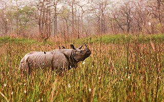
Kaziranga National Park is a national park in the Golaghat, Sonitpur, Biswanath and Nagaon districts of the state of Assam, India. KNP has 5 ranges. The park, which hosts two-thirds of the world's Indian rhinoceroses, is a UNESCO World Heritage Site. According to a March 2018 census conducted jointly by the Forest Department of the Government of Assam and some recognized wildlife NGOs, the rhino population in Kaziranga National Park is 2,613. It comprises 1,641 adult rhinos and 385 calves.

A rhinoceros, commonly abbreviated to rhino, is a member of any of the five extant species of odd-toed ungulates in the family Rhinocerotidae; it can also refer to a member of any of the extinct species of the superfamily Rhinocerotoidea. Two of the extant species are native to Africa, and three to South and Southeast Asia.
Zakouma National Park is a 3,000 km2 (1,158 sq mi) national park in southeastern Chad, straddling the border of Guéra Region and Salamat Region. Zakouma is the nation's oldest national park, declared a national park in 1963 by presidential decree, giving it the highest form of protection available under the nation's laws. It has been managed by the nonprofit conservation organization African Parks since 2010 in partnership with Chad's government.
Orang National Park is a national park in India located on the northern bank of the Brahmaputra River in the Darrang and Sonitpur districts of Assam. It covers an area of 79.28 km2 (30.61 sq mi). It was established as a sanctuary in 1985 and declared a national park on 13 April 1999. It is rich in flora and fauna, including great Indian rhinoceros, pygmy hog, Asian elephant, wild water buffalo and the Bengal tiger. It is the only stronghold of the rhinoceros on the north bank of the Brahmaputra.

Environmental issues in Kenya include deforestation, soil erosion, desertification, water shortage and degraded water quality, flooding, poaching, and domestic and industrial pollution.

Wildlife trade refers to the products that are derived from non-domesticated animals or plants usually extracted from their natural environment or raised under controlled conditions. It can involve the trade of living or dead individuals, tissues such as skins, bones or meat, or other products. Legal wildlife trade is regulated by the United Nations' Convention on International Trade in Endangered Species of Wild Fauna and Flora (CITES), which currently has 184 member countries called Parties. Illegal wildlife trade is widespread and constitutes one of the major illegal economic activities, comparable to the traffic of drugs and weapons.

The International Rhino Foundation (IRF) is a Texas-based charity focused on the conservation of the five species of rhinoceros which include the White Rhinoceros and Black Rhinoceros of Africa, and the Indian Rhinoceros, Javan Rhinoceros and Sumatran Rhinoceros of Asia.

Wildlife observation is the practice of noting the occurrence or abundance of animal species at a specific location and time, either for research purposes or recreation. Common examples of this type of activity are bird watching and whale watching.
The Wildlife Conservation Network (WCN) is a United States–based 501(c)(3) non-profit organization that protects endangered wildlife by supporting conservationists in the field who promote coexistence between wildlife and people. WCN does this by providing its partners with capital, strategic capacity-building services, training, and operational support. WCN has been given a top rating amongst wildlife conservation charities, with a four star rating on Charity Navigator.
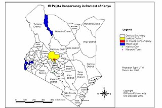
The Ol Pejeta Conservancy is a 360 km2 (140 sq mi) not-for-profit wildlife conservancy in Central Kenya's Laikipia County. It is situated on the equator west of Nanyuki, between the foothills of the Aberdares and Mount Kenya. The Ol Pejeta Conservancy works to conserve wildlife, provide a sanctuary for great apes, and generate income through wildlife tourism and complementary enterprises for re-investment in conservation and community development.
Akashinga, is a non-profit organisation registered in Australia, predominantly operating on the African continent. The group initially created a structured military-like approach to conservation, employing tactics and technology generally reserved for the modern-day battlefield, and has since moved to a community oriented approach. This has included the training of local women as rangers.

Many species are affected by poaching, including illegal hunting, fishing and capturing of wild animals, and, in a recent usage, the illegal harvesting of wild plant species. The article provides an overview of species currently endangered or impaired by poaching in the Americas, sub-Saharan Africa, and South-East Asia.

Koh Lian Pin is a Singaporean conservation scientist. He is Associate Vice President and Chief Sustainability Scientist at the National University of Singapore (NUS), where he oversees and champions sustainability-related research. He employs a whole-of-University strategy to bridge academia with policy makers, industry and civil society, driving the change needed across all sectors to tackle the twin planetary crises of climate change and biodiversity loss.
Wildlife SOS (WSOS) is a conservation non-profit organisation in India, established in 1995 with the primary objective of rescuing and rehabilitating wildlife in distress, and preserving India's natural heritage. It is currently one of the largest wildlife organisations in South Asia.

Smart Parks is a UK-based charity that specializes in providing aerial surveillance and monitoring services through the use of unnamed aerial vehicles (UAVs), commonly knowns as drones. The organization was founded in 2012 and launched publicly in 2013, and operates as a registered charity in the UK and a private foundation in the Netherlands. The organization was formerly named ShadowView.
Human bycatch is a term for people who are unintentionally caught on film, in photos, or acoustically recorded on equipment used to monitor wildlife or habitats for the purpose of conservation, or environmental law enforcement. It comes from the term bycatch, which is used in fishing practices to designate non-target species that are caught in a fishing net. Nearly every remote monitoring study contains human by-catch, yet there are no standardized rules or policies regarding what the researchers can or should do with their data.