Related Research Articles

Stormwater, also written storm water, is water that originates from precipitation (storm), including heavy rain and meltwater from hail and snow. Stormwater can soak into the soil (infiltrate) and become groundwater, be stored on depressed land surface in ponds and puddles, evaporate back into the atmosphere, or contribute to surface runoff. Most runoff is conveyed directly as surface water to nearby streams, rivers or other large water bodies without treatment.

Water pollution is the contamination of water bodies, usually as a result of human activities, so that it negatively affects its uses. Water bodies include lakes, rivers, oceans, aquifers, reservoirs and groundwater. Water pollution results when contaminants mix with these water bodies. Contaminants can come from one of four main sources: sewage discharges, industrial activities, agricultural activities, and urban runoff including stormwater. Water pollution is either surface water pollution or groundwater pollution. This form of pollution can lead to many problems, such as the degradation of aquatic ecosystems or spreading water-borne diseases when people use polluted water for drinking or irrigation. Another problem is that water pollution reduces the ecosystem services that the water resource would otherwise provide.
The Nationwide Urban Runoff Program (NURP) was a research project conducted by the United States Environmental Protection Agency (EPA) between 1979 and 1983. It was the first comprehensive study of urban stormwater pollution across the United States.

A detention basin or retarding basin is an excavated area installed on, or adjacent to, tributaries of rivers, streams, lakes or bays to protect against flooding and, in some cases, downstream erosion by storing water for a limited period of time. These basins are also called dry ponds, holding ponds or dry detention basins if no permanent pool of water exists.

A retention basin, sometimes called a retention pond,wet detention basin, or storm water management pond (SWMP), is an artificial pond with vegetation around the perimeter and a permanent pool of water in its design. It is used to manage stormwater runoff, for protection against flooding, for erosion control, and to serve as an artificial wetland and improve the water quality in adjacent bodies of water.

A combined sewer is a type of gravity sewer with a system of pipes, tunnels, pump stations etc. to transport sewage and urban runoff together to a sewage treatment plant or disposal site. This means that during rain events, the sewage gets diluted, resulting in higher flowrates at the treatment site. Uncontaminated stormwater simply dilutes sewage, but runoff may dissolve or suspend virtually anything it contacts on roofs, streets, and storage yards. As rainfall travels over roofs and the ground, it may pick up various contaminants including soil particles and other sediment, heavy metals, organic compounds, animal waste, and oil and grease. Combined sewers may also receive dry weather drainage from landscape irrigation, construction dewatering, and washing buildings and sidewalks.

Rain gardens, also called bioretention facilities, are one of a variety of practices designed to increase rain runoff reabsorption by the soil. They can also be used to treat polluted stormwater runoff. Rain gardens are designed landscape sites that reduce the flow rate, total quantity, and pollutant load of runoff from impervious urban areas like roofs, driveways, walkways, parking lots, and compacted lawn areas. Rain gardens rely on plants and natural or engineered soil medium to retain stormwater and increase the lag time of infiltration, while remediating and filtering pollutants carried by urban runoff. Rain gardens provide a method to reuse and optimize any rain that falls, reducing or avoiding the need for additional irrigation. A benefit of planting rain gardens is the consequential decrease in ambient air and water temperature, a mitigation that is especially effective in urban areas containing an abundance of impervious surfaces that absorb heat in a phenomenon known as the heat-island effect.

Surface runoff is the unconfined flow of water over the ground surface, in contrast to channel runoff. It occurs when excess rainwater, stormwater, meltwater, or other sources, can no longer sufficiently rapidly infiltrate in the soil. This can occur when the soil is saturated by water to its full capacity, and the rain arrives more quickly than the soil can absorb it. Surface runoff often occurs because impervious areas do not allow water to soak into the ground. Furthermore, runoff can occur either through natural or human-made processes.

Sustainable drainage systems are a collection of water management practices that aim to align modern drainage systems with natural water processes and are part of a larger green infrastructure strategy. SuDS efforts make urban drainage systems more compatible with components of the natural water cycle such as storm surge overflows, soil percolation, and bio-filtration. These efforts hope to mitigate the effect human development has had or may have on the natural water cycle, particularly surface runoff and water pollution trends.
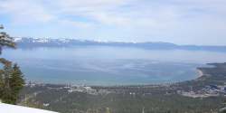
The DSSAM Model is a computer simulation developed for the Truckee River to analyze water quality impacts from land use and wastewater management decisions in the Truckee River Basin. This area includes the cities of Reno and Sparks, Nevada as well as the Lake Tahoe Basin. The model is historically and alternatively called the Earth Metrics Truckee River Model. Since original development in 1984-1986 under contract to the U.S. Environmental Protection Agency (EPA), the model has been refined and successive versions have been dubbed DSSAM II and DSSAM III. This hydrology transport model is based upon a pollutant loading metric called Total maximum daily load (TMDL). The success of this flagship model contributed to the Agency's broadened commitment to the use of the underlying TMDL protocol in its national policy for management of most river systems in the United States.
Best management practices (BMPs) is a term used in the United States and Canada to describe a type of water pollution control. Historically the term has referred to auxiliary pollution controls in the fields of industrial wastewater control and municipal sewage control, while in stormwater management and wetland management, BMPs may refer to a principal control or treatment technique as well.
Watershed management is the study of the relevant characteristics of a watershed aimed at the sustainable distribution of its resources and the process of creating and implementing plans, programs and projects to sustain and enhance watershed functions that affect the plant, animal, and human communities within the watershed boundary. Features of a watershed that agencies seek to manage to include water supply, water quality, drainage, stormwater runoff, water rights and the overall planning and utilization of watersheds. Landowners, land use agencies, stormwater management experts, environmental specialists, water use surveyors and communities all play an integral part in watershed management.
CMAC is the Cipher-based Message Authentication Code, a cryptographic algorithm.

An infiltration basin is a form of engineered sump or percolation pond that is used to manage stormwater runoff, prevent flooding and downstream erosion, and improve water quality in an adjacent river, stream, lake or bay. It is essentially a shallow artificial pond that is designed to infiltrate stormwater through permeable soils into the groundwater aquifer. Infiltration basins do not release water except by infiltration, evaporation or emergency overflow during flood conditions.
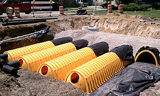
A stormwater detention vault is an underground structure designed to manage excess stormwater runoff on a developed site, often in an urban setting. This type of best management practice may be selected when there is insufficient space on the site to infiltrate the runoff or build a surface facility such as a detention basin or retention basin.

Urban runoff is surface runoff of rainwater, landscape irrigation, and car washing created by urbanization. Impervious surfaces are constructed during land development. During rain, storms, and other precipitation events, these surfaces, along with rooftops, carry polluted stormwater to storm drains, instead of allowing the water to percolate through soil. This causes lowering of the water table and flooding since the amount of water that remains on the surface is greater. Most municipal storm sewer systems discharge untreated stormwater to streams, rivers, and bays. This excess water can also make its way into people's properties through basement backups and seepage through building wall and floors.

A check dam is a small, sometimes temporary, dam constructed across a swale, drainage ditch, or waterway to counteract erosion by reducing water flow velocity. Check dams themselves are not a type of new technology; rather, they are an ancient technique dating from the second century AD. Check dams are typically, though not always, implemented in a system of several dams situated at regular intervals across the area of interest.
The Southern California Coastal Water Research Project (SCCWRP) is a research institute focusing on the coastal ecosystems of Southern California from watersheds to the ocean. SCCWRP was created as a joint powers authority (JPA), which is an agency formed when multiple government agencies have a common mission that can be better achieved by pooling resources and knowledge. The purpose of SCCWRP is to gather the necessary scientific information to allow member agencies to effectively and cost-efficiently steward the Southern California coastal environment.

Water-sensitive urban design (WSUD) is a land planning and engineering design approach which integrates the urban water cycle, including stormwater, groundwater, and wastewater management and water supply, into urban design to minimise environmental degradation and improve aesthetic and recreational appeal. WSUD is a term used in the Middle East and Australia and is similar to low-impact development (LID), a term used in the United States; and Sustainable Drainage System (SuDS), a term used in the United Kingdom.

Low-impact development (LID) is a term used in Canada and the United States to describe a land planning and engineering design approach to manage stormwater runoff as part of green infrastructure. LID emphasizes conservation and use of on-site natural features to protect water quality. This approach implements engineered small-scale hydrologic controls to replicate the pre-development hydrologic regime of watersheds through infiltrating, filtering, storing, evaporating, and detaining runoff close to its source. Green infrastructure investments are one approach that often yields multiple benefits and builds city resilience.
References
- ↑ Jamie Lefkowitz; Alexa Sarmanian; Marcus Quigley (Spring 2016). "Continuous monitoring and adaptive control—the internet of things transforms stormwater management" (PDF). Journal of the New England Water Environment Association. 50 (1): 44–51. ISSN 1077-3002.
- ↑ "Advancements in Monitoring and RealTime Control Technology Result in Improved Stormwater Management" (PDF). Ohio Stormwater Conference. Retrieved 2 June 2016.