Related Research Articles

The San Juan Islands is an archipelago in the Pacific Northwest of the United States between the U.S. state of Washington and Vancouver Island, British Columbia, Canada. The San Juan Islands are part of Washington state, and form the core of San Juan County.

The Strait of Juan de Fuca is a body of water about 96 miles long that is the Salish Sea's main outlet to the Pacific Ocean. The international boundary between Canada and the United States runs down the centre of the Strait.
The Pacific Northwest (PNW), sometimes referred to as Cascadia, is a geographic region in western North America bounded by its coastal waters of the Pacific Ocean to the west and, loosely, by the Rocky Mountains to the east. Though no official boundary exists, the most common conception includes the U.S. states of Oregon, Washington, Idaho, and the Canadian province of British Columbia. Some broader conceptions reach north into Alaska and Yukon, south into northern California, and east into western Montana. Other conceptions may be limited to the coastal areas west of the Cascade and Coast mountains. The variety of definitions can be attributed to partially overlapping commonalities of the region's history, culture, geography, society, ecosystems, and other factors.

The Willamette River is a major tributary of the Columbia River, accounting for 12 to 15 percent of the Columbia's flow. The Willamette's main stem is 187 miles (301 km) long, lying entirely in northwestern Oregon in the United States. Flowing northward between the Oregon Coast Range and the Cascade Range, the river and its tributaries form the Willamette Valley, a basin that contains two-thirds of Oregon's population, including the state capital, Salem, and the state's largest city, Portland, which surrounds the Willamette's mouth at the Columbia.

Multnomah County is one of the 36 counties in the U.S. state of Oregon. As of the 2020 census, the county's population was 815,428. Multnomah County is part of the Portland–Vancouver–Hillsboro, OR–WA metropolitan statistical area. Though smallest in area, Multnomah County is the state's most populous county. Its county seat, Portland, is the state's largest city.
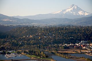
The city of Hood River is the seat of Hood River County, Oregon, United States. It is a port on the Columbia River, and is named for the nearby Hood River. As of the 2020 census, the city population was 8,313. It is the only city in Oregon where public consumption of alcohol on sidewalks or parks is totally unrestricted.
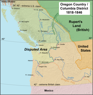
The Oregon Treaty is a treaty between the United Kingdom and the United States that was signed on June 15, 1846, in Washington, D.C. The treaty brought an end to the Oregon boundary dispute by settling competing American and British claims to the Oregon Country; the area had been jointly occupied by both Britain and the U.S. since the Treaty of 1818.
The Multnomah are a tribe of Chinookan people who live in the area of Portland, Oregon, in the United States. Multnomah villages were located throughout the Portland basin and on both sides of the Columbia River. The Multnomah speak a dialect of the Upper Chinookan language in the Oregon Penutian family.

The John Day River is a tributary of the Columbia River, approximately 6 miles (10 km) long, in northwestern Oregon in the United States. The river rises in the Northern Oregon Coast Range in Clatsop County at 46.138889°N 123.704722°W.

Rooster Rock State Park is a state park located east of Corbett, in the U.S. state of Oregon. One of the features of the park is Rooster Rock, a column of basalt forming a natural obelisk, which stands near the south side of the Columbia River Gorge, in the lee of Crown Point. The park is administered by the Oregon Parks and Recreation Department.

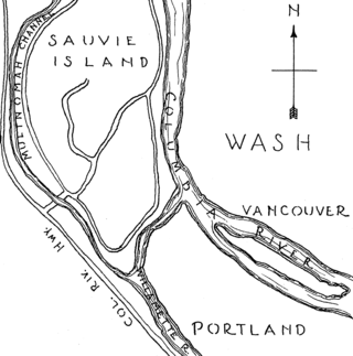
The Multnomah Channel is a 21.5-mile (34.6 km) distributary of the Willamette River. It diverges from the main stem a few miles upstream of the main stem's confluence with the Columbia River in Multnomah County in the U.S. state of Oregon. The channel flows northwest then north around Sauvie Island to meet the Columbia River near the city of St. Helens, in Columbia County.

Government Island is a 1,760-acre (710 ha) island in the Columbia River north of Portland, in Multnomah County, in the U.S. state of Oregon. Though Interstate 205 passes over it on the Glenn L. Jackson Memorial Bridge, access to the island is only by boat. There is a city controlled locked gate in the fence surrounding the freeway.
Catala Island Marine Provincial Park is a provincial park in British Columbia, Canaded on the west coast of Vancouver Island at the mouth of Esperanza Inlet, between Kyuquot Sound (N) and Nootka Sound (S). The park is 955 ha. in size and was established in July 1995.
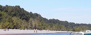
Collins Beach is a sandy beach on the Columbia River side of Sauvie Island in Oregon, United States, located north of Portland.

Kelley Point Park is a city park in north Portland in the U.S. state of Oregon. Bounded by the Columbia Slough on the south, the Willamette River on the west, and the Columbia River on the north, the park forms the tip of the peninsula at the confluence of the rivers. Marine Terminal 6 of the Port of Portland lies immediately east of the park along the Columbia, while Terminal 5 is along the Willamette slightly south of the Columbia Slough. The park is at 45.6498384°N 122.7637106°W and rises to an elevation of 39 feet (12 m) above sea level. Sauvie Island is west of the park across the Willamette River. Hayden Island is slightly upstream of the park on the Columbia River opposite Marine Terminal 6.

Blue Lake Regional Park is a public park in Fairview, in the U.S. state of Oregon. The 101-acre (41 ha) park, near the south shore of the Columbia River in Multnomah County, includes many covered and uncovered picnic areas, playing fields for sports such as softball, a cross country course and infrastructure related to lake recreation including swimming, boating, and fishing. Encompassing wooded areas, three ponds, and a wetland in addition to the lake, the park is frequented by migrating birds and other wildlife. Paved paths run through the park, which is near the 40-Mile Loop hiking and biking trail. Park vegetation includes cottonwoods, willows, and other trees and shrubs as well as wetland plants such as cattails.

The Willamette River is a 187-mile (301 km) tributary of the Columbia River in the U.S. state of Oregon. The upper tributaries of the Willamette originate in mountains south and southeast of the twin cities of Eugene and Springfield. Formed by the confluence of the Middle Fork Willamette River and Coast Fork Willamette River near Springfield, the main stem meanders generally north from source to mouth. The river's two most significant course deviations occur at Newberg, where the stream turns sharply east, and about 18 miles (29 km) downriver from Newberg, where it turns north again. Near its mouth, the river splits into two channels that flow around Sauvie Island. The main channel enters the Columbia about 101 miles (163 km) from the larger stream's mouth on the Pacific Ocean, and the smaller Multnomah Channel enters the Columbia about 14.5 miles (23.3 km) further downstream near St. Helens in Columbia County.

Hyak was a wooden-hulled steamship that operated on Puget Sound from 1909 to 1941. This vessel should not be confused with the sternwheeler Hyak which ran on the extreme upper reach of the Columbia River at about the same time. The name means "swift" or "fast" in the Chinook Jargon.

Dayton was a steamboat which operated on the Willamette and Columbia rivers from 1868 to 1881. Dayton operated on the Willamette from 1868 to 1876, mostly upriver from Willamette Falls, including a route on the Yamhill River to Dayton, Oregon, after which the steamer was named. From 1876 to 1881, Dayton was employed on a run from Portland to Monticello, W.T., which was located on the site of what is now Longview, Washington.
References
- ↑ "JJ Collins Marine Park". Columbia County, Oregon. Retrieved November 12, 2016.
- ↑ "JJ Collins "Coon Island" Park". Willamette River Water Trail. Retrieved November 12, 2016.
| | This Columbia County, Oregon state location article is a stub. You can help Wikipedia by expanding it. |