Cooper, United States Virgin Islands | |
|---|---|
Village | |
| Country | |
| Island | Saint Croix |
| Time zone | UTC-4 (AST) |
Cooper is a settlement on the island of Saint Croix in the United States Virgin Islands.
Cooper, United States Virgin Islands | |
|---|---|
Village | |
| Country | |
| Island | Saint Croix |
| Time zone | UTC-4 (AST) |
Cooper is a settlement on the island of Saint Croix in the United States Virgin Islands.

Clarks Green is a borough in Lackawanna County, Pennsylvania, United States. The population was 1,476 at the 2010 census.

Parris Island is a former census-designated place (CDP) in Beaufort County, South Carolina, United States, and formerly also spelled Paris Island. The population was 4,841 at the 2000 census. As defined by the U.S. Census Bureau, Parris Island is included within the Beaufort Urban Cluster and the larger Hilton Head Island–Beaufort Micropolitan Statistical Area. The area was annexed by the town of Port Royal on October 11, 2002.
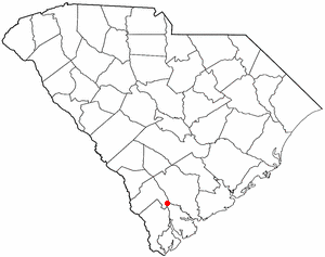
Yemassee is a small Lowcountry town in Beaufort and Hampton counties in the U.S. state of South Carolina. The population was 1,027 at the 2010 census. Yemassee is near the borders of Colleton and Jasper counties. The town is divided by the county line between Beaufort and Hampton counties, which follows the roadbed of the CSX railroad. Most of the town's population presently lies within Hampton County. As defined by the U.S. Census Bureau, the Beaufort County portion of Yemassee is included within the Hilton Head Island-Bluffton-Beaufort, SC Metropolitan Statistical Area. Yemassee hosts one of the few commercial breeding facilities of non-human primates in the entire United States, Alpha Genesis, Inc., which serves as a major employer for the town. Also, the Frank Lloyd Wright-designed Auldbrass Plantation house and outbuildings lie just outside the town limits of Yemassee.
Alva is an unincorporated community in north central Crook County, Wyoming, United States. It lies along WYO 24, 34.9 miles north of the town of Sundance, the county seat of Crook County and 9.7 miles away from Hulett. Its elevation is 3,993 feet (1,217 m), and it is located at 44°41′41″N104°26′29″W. Although Alva is unincorporated, it has a post office, with the ZIP code of 82711. Population is 50.

St. Sennen's Church, Sennen is a parish church in the Church of England located in Sennen, Cornwall, England, UK.

Sienica is a settlement in the administrative district of Gmina Czersk, within Chojnice County, Pomeranian Voivodeship, in northern Poland. It lies approximately 6 kilometres (4 mi) west of Czersk, 26 km (16 mi) north-east of Chojnice, and 79 km (49 mi) south-west of the regional capital Gdańsk.
Camporico is a settlement on the island of Saint Croix in the United States Virgin Islands.
Envy is a settlement on the island of Saint Croix in the United States Virgin Islands.
Good Hope is a settlement on the island of Saint Croix in the United States Virgin Islands.
Hesselberg is a settlement on the island of Saint Croix in the United States Virgin Islands.
Laprey Valley is a settlement on the island of Saint Croix in the United States Virgin Islands.
Longford is a settlement on the island of Saint Croix in the United States Virgin Islands.
Morningstar is a settlement on the island of Saint Croix in the United States Virgin Islands.
Munster is a settlement on the island of Saint Croix in the United States Virgin Islands.
Pleasant Vale is a settlement on the island of Saint Croix in the United States Virgin Islands.
Recovery Hill is a settlement on the island of Saint Croix in the United States Virgin Islands.
Saint Peter is a settlement on the island of Saint Croix in the United States Virgin Islands.
Sandy Point is a settlement on the island of Saint Croix in the United States Virgin Islands.
Smithfield is a settlement on the island of Saint Croix in the United States Virgin Islands.
Coordinates: 17°41′41″N64°48′36″W / 17.69472°N 64.81000°W
| | This Saint Croix, United States Virgin Islands location article is a stub. You can help Wikipedia by expanding it. |