
The National Oceanic and Atmospheric Administration is a Washington, D.C.–based scientific and regulatory agency within the United States Department of Commerce, a United States federal government department. The agency is charged with forecasting weather, monitoring oceanic and atmospheric conditions, charting the seas, conducting deep sea exploration, and managing fishing and protection of marine mammals and endangered species in the U.S. exclusive economic zone.

The Geostationary Operational Environmental Satellite (GOES), operated by the United States' National Oceanic and Atmospheric Administration (NOAA)'s National Environmental Satellite, Data, and Information Service division, supports weather forecasting, severe storm tracking, and meteorology research. Spacecraft and ground-based elements of the system work together to provide a continuous stream of environmental data. The National Weather Service (NWS) and the Meteorological Service of Canada use the GOES system for their North American weather monitoring and forecasting operations, and scientific researchers use the data to better understand land, atmosphere, ocean, and climate dynamics.

A weather satellite or meteorological satellite is a type of Earth observation satellite that is primarily used to monitor the weather and climate of the Earth. Satellites can be polar orbiting, or geostationary.

The National Weather Service (NWS) is an agency of the United States federal government that is tasked with providing weather forecasts, warnings of hazardous weather, and other weather-related products to organizations and the public for the purposes of protection, safety, and general information. It is a part of the National Oceanic and Atmospheric Administration (NOAA) branch of the Department of Commerce, and is headquartered in Silver Spring, Maryland, within the Washington metropolitan area. The agency was known as the United States Weather Bureau from 1890 until it adopted its current name in 1970.

The Nimbus satellites were second-generation U.S. robotic spacecraft launched between 1964 and 1978 used for meteorological research and development. The spacecraft were designed to serve as stabilized, Earth-oriented platforms for the testing of advanced systems to sense and collect atmospheric science data. Seven Nimbus spacecraft have been launched into near-polar, sun-synchronous orbits beginning with Nimbus 1 on August 28, 1964. On board the Nimbus satellites are various instrumentation for imaging, sounding, and other studies in different spectral regions. The Nimbus satellites were launched aboard Thor-Agena rockets and Delta rockets.

The European Organisation for the Exploitation of Meteorological Satellites (EUMETSAT) is an intergovernmental organisation created through an international convention agreed by a current total of 30 European Member States.

This is a list of meteorology topics. The terms relate to meteorology, the interdisciplinary scientific study of the atmosphere that focuses on weather processes and forecasting.
Oceanic and Atmospheric Research (OAR) is a division of the National Oceanic and Atmospheric Administration (NOAA). OAR is also referred to as NOAA Research.
The Atlantic Oceanographic and Meteorological Laboratory (AOML), a federal research laboratory, is part of the National Oceanic and Atmospheric Administration's (NOAA) Office of Oceanic and Atmospheric Research (OAR), located in Miami in the United States. AOML's research spans tropical cyclone and hurricanes, coastal ecosystems, oceans and human health, climate studies, global carbon systems, and ocean observations. It is one of seven NOAA Research Laboratories (RLs).
The National Severe Storms Laboratory (NSSL) is a National Oceanic and Atmospheric Administration (NOAA) weather research laboratory under the Office of Oceanic and Atmospheric Research. It is one of seven NOAA Research Laboratories (RLs).
The Cooperative Institute for Mesoscale Meteorological Studies is a research organization created in 1978 by a cooperative agreement between the University of Oklahoma (OU) and the National Oceanic and Atmospheric Administration (NOAA). CIMMS promotes collaborative research between NOAA and OU scientists on problems of mutual interest to improve basic understanding of mesoscale meteorological phenomena, weather radar, and regional climate to help produce better forecasts and warnings that save lives and property. CIMMS research contributes to the NOAA mission through improvement of the observation, analysis, understanding, and prediction of weather elements and systems and climate anomalies ranging in size from cloud nuclei to multi-state areas.

The Cooperative Institute for Research in Environmental Sciences (CIRES) is a research institute that is sponsored jointly by the National Oceanic and Atmospheric Administration (NOAA) Office of Oceanic and Atmospheric Research (OAR) and the University of Colorado Boulder (CU). CIRES scientists study the Earth system, including the atmosphere, hydrosphere, cryosphere, biosphere, and geosphere, and communicate these findings to decision makers, the scientific community, and the public.

A tropical cyclone forecast model is a computer program that uses meteorological data to forecast aspects of the future state of tropical cyclones. There are three types of models: statistical, dynamical, or combined statistical-dynamic. Dynamical models utilize powerful supercomputers with sophisticated mathematical modeling software and meteorological data to calculate future weather conditions. Statistical models forecast the evolution of a tropical cyclone in a simpler manner, by extrapolating from historical datasets, and thus can be run quickly on platforms such as personal computers. Statistical-dynamical models use aspects of both types of forecasting. Four primary types of forecasts exist for tropical cyclones: track, intensity, storm surge, and rainfall. Dynamical models were not developed until the 1970s and the 1980s, with earlier efforts focused on the storm surge problem.

The Dvorak technique is a widely used system to estimate tropical cyclone intensity based solely on visible and infrared satellite images. Within the Dvorak satellite strength estimate for tropical cyclones, there are several visual patterns that a cyclone may take on which define the upper and lower bounds on its intensity. The primary patterns used are curved band pattern (T1.0-T4.5), shear pattern (T1.5–T3.5), central dense overcast (CDO) pattern (T2.5–T5.0), central cold cover (CCC) pattern, banding eye pattern (T4.0–T4.5), and eye pattern (T4.5–T8.0).

The Hurricane Weather Research and Forecasting (HWRF) model is a specialized version of the weather research and forecasting model and is used to forecast the track and intensity of tropical cyclones. The model was developed by the National Oceanic and Atmospheric Administration (NOAA), the U.S. Naval Research Laboratory, the University of Rhode Island, and Florida State University. It became operational in 2007.
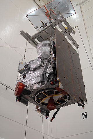
GOES-14, known as GOES-O prior to reaching its operational orbit, is an American weather satellite, which is part of the US National Oceanic and Atmospheric Administration (NOAA)'s Geostationary Operational Environmental Satellite (GOES) system. The spacecraft was built by Boeing and is based on the BSS-601 bus. It is the second of three GOES satellites to use the BSS-601 bus, after GOES-13, which was launched in May 2006.

The Antarctic Meteorological Research Center (AMRC) is an Antarctic research program funded by the National Science Foundation (NSF) that is based out of the Space Science and Engineering Center (SSEC) at the University of Wisconsin. The AMRC was founded as a link between the UW-Madison automatic weather station (AWS) project and the Man computer Interactive Data Access System (McIDAS) project, also at UW-Madison.
The following is a glossary of tornado terms. It includes scientific as well as selected informal terminology.
The AN/UMQ-13(V) system or MARK IVB, is a meteorological data station that is owned and operated by the United States Air Force. This system allows meteorologists from around the globe to analyze and forecast meteorological data from polar orbiting satellites belonging to, National Oceanic and Atmospheric Administration (NOAA), Defense Meteorological Satellite Program (DMSP). The MARK IVB also uses geostationary orbiting satellites to include Geostationary Operational Environmental Satellites (GOES), Japan's Geostationary Meteorological Satellite (GMS), and Meteosat which is operated in cooperation between EUMETSAT and the European Space Agency.