
The Bureau of Land Management (BLM) is an agency within the United States Department of the Interior responsible for administering U.S. federal lands. Headquartered in Washington, D.C., the BLM oversees more than 247.3 million acres (1,001,000 km2) of land, or one-eighth of the United States's total landmass.

Coos County is one of the 36 counties in the U.S. state of Oregon. As of the 2020 census, the population was 64,929. The county seat is Coquille. The county was formed from the western parts of Umpqua and Jackson counties. It is named after a tribe of Native Americans who live in the region. Coos County comprises the Coos Bay, OR Micropolitan Statistical Area.
The Oregon and California Railroad was formed from the Oregon Central Railroad when it was the first to operate a 20-mile (32 km) stretch south of Portland in 1869. This qualified the railroad for land grants in California, whereupon the name of the railroad soon changed to Oregon & California Rail Road Company. In 1887, the line was completed over Siskiyou Summit, and the Southern Pacific Railroad assumed control of the railroad, although it was not officially sold to Southern Pacific until January 3, 1927. This route was eventually spun off from the Southern Pacific as the Central Oregon and Pacific Railroad.

Federal lands are lands in the United States owned and managed by the federal government. Pursuant to the Property Clause of the United States Constitution, Congress has the power to retain, buy, sell, and regulate federal lands, such as by limiting cattle grazing on them. These powers have been recognized in a long series of United States Supreme Court decisions.

The Taylor Grazing Act of 1934 is a United States federal law that provides for the regulation of grazing on the public lands to improve rangeland conditions and regulate their use.

The Central Oregon & Pacific Railroad is a Class II railroad operating between Northern California and Eugene, Oregon, United States. It was previously a mainline owned by the Southern Pacific Railroad (SP) between Eugene and Weed, California via Medford, Oregon. SP sold the route on December 31, 1994, in favor of using its route to Eugene via Klamath Falls, Oregon and Cascade Summit.
The Coquille Indian Tribe is the federally recognized Native American tribe of the Coquille people who have traditionally lived on the southern Oregon Coast.

Umpqua National Forest, in southern Oregon's Cascade Range, covers an area of 983,129 acres (3,978.58 km2) in Douglas, Lane, and Jackson counties, and borders the Crater Lake National Park in Southern Oregon. The four ranger districts for the forest are the Cottage Grove, Diamond Lake, North Umpqua, and Tiller ranger districts. The national forest is managed by the United States Forest Service, headquartered in Roseburg, Oregon in the Pacific Northwest region of the Western United States.

Abraham Walter Lafferty was a U.S. Representative from the state of Oregon. Lafferty spent the majority of his career both as a legislator and as an attorney attempting to have millions of acres of land previously owned by the Oregon and California Railroad come under Oregon state control, rather than the control of the U.S. federal government.

According to the California Protected Areas Database (CPAD), in the state of California, United States, there are over 14,000 inventoried protected areas administered by public agencies and non-profits. In addition, there are private conservation areas and other easements. They include almost one-third of California's scenic coastline, including coastal wetlands, estuaries, beaches, and dune systems. The California State Parks system alone has 270 units and covers 1.3 million acres (5,300 km2), with over 280 miles (450 km) of coastline, 625 miles (1,006 km) of lake and river frontage, nearly 18,000 campsites, and 3,000 miles (5,000 km) of hiking, biking, and equestrian trails.

The U.S. state of Oregon has had an evolving set of laws affecting land ownership and its restrictions.

The history of steamboats on the Oregon Coast begins in the late 19th century. Before the development of modern road and rail networks, transportation on the coast of Oregon was largely water-borne. This article focuses on inland steamboats and similar craft operating in, from south to north on the coast: Rogue River, Coquille River, Coos Bay, Umpqua River, Siuslaw Bay, Yaquina Bay, Siletz River, and Tillamook Bay. The boats were all very small, nothing like the big sternwheelers and propeller boats that ran on the Columbia River or Puget Sound. There were many of them, however, and they came to be known as the "mosquito fleet."

Santiam State Forest is one of six state forests managed by the Oregon Department of Forestry. The forest is located approximately 25 miles (40 km) southeast of Salem, Oregon, and includes 47,871 acres (193.73 km2) on the western slope of the Cascade Mountains in three Oregon counties: Clackamas, Linn, and Marion. It is bounded on the east by the Willamette National Forest and Mount Hood National Forest. Silver Falls State Park is located west of the forest. The rest of the land surrounding the forest belongs to the Bureau of Land Management or is privately owned. The forest is managed as part of the Department of Forestry's North Cascade District.
The Chamberlain–Ferris Act of June 9, 1916 was an Act of the United States Congress that ruled that 2,800,000 acres (11,000 km2) of the original 4,000,000 acres (16,000 km2) granted to the Southern Pacific Company in California and Oregon were revested to the United States, and put under the control of the United States General Land Office, which was to dispose of the lands and timber through auction sales. The lands were named the Oregon and California Railroad Revested Lands.
County payments are the United States Forest Service payments of 25% of gross revenues from each national forest to the states for use on the road and school programs in the counties where the national forests are located. The payments are technically known as Payments to States, because the states determine which road and school programs can be funded. However, the payments are allocated to the counties based on the national forest acreage in each county. County payments were modified temporarily by the Secure Rural Schools and Community Self-Determination Act of 2000.
The Secure Rural Schools and Community Self-Determination Act of 2000 was a bill passed into law by the United States Congress on October 30, 2000. The law amended the United States Forest Service's county payments program for FY2001-FY2006 to allow states or counties to choose to receive the average of the three highest payments for FY1986-FY1999 in lieu of the regular 25% payment, but requiring that 15–20% of those payments be used by the counties for specified purposes, in accordance with recommendations of resource advisory committees for projects on federal lands, or returned to the Treasury.
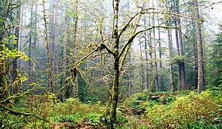
Elliott State Forest is a state forest in Coos and Douglas counties of the U.S. state of Oregon, between Coos Bay and Reedsport in the Oregon Coast Range. The first state forest established in Oregon, it is named after the state's first state forester Francis Elliott. Trees commonly found in this forest are the Douglas-fir, western hemlock, western redcedar, bigleaf maple, and red alder.

The Coos Bay Wagon Road or Coos Bay Military Wagon Road was a pioneer road in the U.S. state of Oregon that connected Douglas County to Coos Bay starting in 1872. Travelers on the road could start in either Tenmile or Lookingglass near Roseburg. The route passed through Reston, Sitkum, Dora, McKinley, and Fairview, ending in Sumner south of Coos Bay. Eventually the road was continued to Eastside, now a neighborhood of Coos Bay. The road follows the East Fork Coquille River from near the Coos/Douglas county line to Dora.
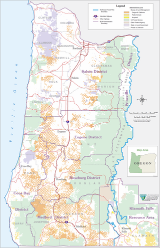
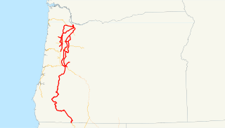
The Oregon and California Railroad Revested Lands, are approximately 2,600,000 acres (1,100,000 ha) of land located in eighteen counties of western Oregon. Originally granted to the Oregon & California Railroad to build a railroad between Portland, Oregon and San Francisco, California, the land was reconveyed to the United States government by act of Congress in 1916 and is currently managed by the United States Bureau of Land Management.
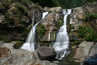
Coquiller River Falls, is a two-tier waterfall located in the far north tip of the Rogue River – Siskiyou National Forest, just east of Port Orford, on the Oregon Coast in Coos County, in the U.S. state of Oregon. It totals 115 feet fall in two drops: the upper falls is 50 feet high and the lower tier, the tallest drop, is 65 feet. There are approximately 180 feet from the upper tier to the bottom drop of the waterfall.