Cootapatamba Hut

Last updated

Cootapatamba Hut
Cootapatamba Hut.jpg
A skier rests outside Cootapatamba Hut in late September 2010
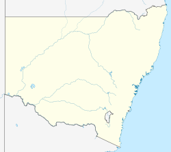
Australia New South Wales location map blank.svg
Red pog.svg
Cootapatamba Hut
Coordinates 36°28′39.2″S148°15′22.2″E / 36.477556°S 148.256167°E / -36.477556; 148.256167
Country Australia
State/territory New South Wales
National park Kosciuszko National Park
Construction
Built forEmergency and day shelter
Administration
Maintained by National Parks and Wildlife Service
Accessibility
Accessed byFoot or skis

Cootapatamba Hut is a survival shelter in the river valley south of Mount Kosciuszko, in the Kosciuszko National Park, New South Wales, Australia.

The hut was originally built by the Snowy Mountains Hyrdo-Electrict Authority [1] [2] , previously known as the Snowy Mountains Authority (SMA), in the 1950s, as part of the Snowy Mountains Hydro-electric Scheme [2] [3] . The hut was placed strategically in the river valley to catch people leaving the summit of Mount Kosciusko in poor weather, where the path down the valley would appear to head to safer areas, despite it leading into deeper wilderness [1] . The bright red paint means the hut is clearly visible from Mount Kosciusko. [4]

In early 2019, after inspecting the hut, the National Parks and Wildlife Service (NPSW) inspected the hut and decided that it should be rebuilt. Due to the hut being heritage listed, the design had to comply with strict heritage guidelines. In February and March 2019, the old hut was moved. A new frame, using steel supports, was concreted into position. By April 2019, following multiple setbacks, including bushfires and gale force winds, the new replica hut was completed. [5]

The hut has two entrances: One from a door at ground level, and another on the roof to access the hut in deep snow. [6] [1]
  1. 1 2 3 south, KHA HMO. "Cootapatamba Hut - KHA Website". khuts.org. Retrieved 28 November 2024.
  2. 1 2 Higgins, Matthew (1 August 2024). "Our early weathermen". Australian Geographic. Retrieved 28 November 2024.
  3. "Cootapatamba Hut Historical Background - KHA Website". khuts.org. Retrieved 28 November 2024.
  4. "Day 15, Wangaratta to Sydney | Centre for Ecosystem Science - UNSW Sydney". UNSW Sites. Retrieved 28 November 2024.
  5. "Feb to Mar 2019 - Cootapatamba Hut Rebuild". Southern Alps Ski Club. 25 March 2019. Retrieved 28 November 2024.
  6. "Cootapatamba Hut". Mountain Huts Australia. Retrieved 28 November 2024.

Related Research Articles

<span class="mw-page-title-main">Snowy Mountains</span> Mountain range in Australia

The Snowy Mountains, known informally as "The Snowies", is an IBRA subregion in southern New South Wales, Australia, and is the tallest mountain range in mainland Australia, being part of the continent's Great Dividing Range cordillera system. It makes up the northeastern half of the Australian Alps and contains Australia's five tallest peaks, all of which are above 2,100 m (6,890 ft), including the tallest Mount Kosciuszko, which reaches to a height of 2,228 m (7,310 ft) above sea level. The offshore Tasmanian highlands makes up the only other major alpine region present in the whole of Australia.

The Kosciuszko National Park is a 6,900-square-kilometre (2,700 sq mi) national park and contains mainland Australia's highest peak, Mount Kosciuszko, for which it is named, and Cabramurra, the highest town in Australia. Its borders contain a mix of rugged mountains and wilderness, characterised by an alpine climate, which makes it popular with recreational skiers and bushwalkers.

<span class="mw-page-title-main">Mount Kosciuszko</span> Highest mountain in mainland Australia

Mount Kosciuszko is mainland Australia's highest mountain, at 2,228 metres (7,310 ft) above sea level. It is located on the Main Range of the Snowy Mountains in Kosciuszko National Park, part of the Australian Alps National Parks and Reserves, in New South Wales, Australia, and is located west of Crackenback and close to Jindabyne, near the border with Victoria. Mount Kosciuszko is ranked 35th by topographic isolation.

Tadeusz Kościuszko was a soldier respected as a champion of liberty in both Poland and the United States.

<span class="mw-page-title-main">Australian Alps</span> Bioregion in Australia

The Australian Alps are a mountain range in southeast Australia. The range comprises an interim Australian bioregion, and is the highest mountain range in Australia. The range straddles the borders of eastern Victoria, southeastern New South Wales, and the Australian Capital Territory. It contains Australia's only peaks exceeding 2,000 m (6,600 ft) in elevation, and is the only bioregion on the Australian mainland in which deep snow falls annually. The range comprises an area of 1,232,981 ha.

<span class="mw-page-title-main">Alpine Way</span>

Alpine Way is a 121-kilometre (75 mi) rural road located in the Snowy Mountains region of New South Wales, Australia. The road connects Jindabyne in the east to the New South Wales-Victorian border in the west, crossing the Murray River near Bringenbrong and Upper Towong.

<span class="mw-page-title-main">Charlotte Pass, New South Wales</span> Ski resort in New South Wales, Australia

Charlotte Pass is a snow resort and village in the Snowy Mountains of New South Wales, Australia. The pass is in the Kosciuszko National Park where the Kosciuszko Road crosses Kangaroo Ridge. Charlotte Pass is the closest village to Mount Kosciuszko, the tallest mountain in Australia.

<span class="mw-page-title-main">Perisher Valley, New South Wales</span> Human settlement in New South Wales, Australia

Perisher Valley, commonly called Perisher, is a valley formed below Mount Perisher, a mountain that is located in the Snowy Mountains of New South Wales, Australia.

<span class="mw-page-title-main">Mount Townsend (Snowy Mountains)</span> Mountain in New South Wales, Australia

Mount Townsend, a mountain in the Main Range of the Great Dividing Range, is located in the Snowy Mountains region of New South Wales, Australia.

<span class="mw-page-title-main">Kiandra, New South Wales</span> Town in New South Wales, Australia

Kiandra is an abandoned gold mining town and the birthplace of Australian skiing. The town is situated in the Snowy Mountains of New South Wales, Australia, in the Snowy Monaro Regional Council inside the Kosciuszko National Park. Its name is a corruption of Aboriginal 'Gianderra' for 'sharp stones for knives'. It was earlier called Gibson's Plains, named after a Dr. Gibson, a settler in the district in 1839. For a century, Kiandra was Australia's highest town.

<span class="mw-page-title-main">Guthega, New South Wales</span> Town in New South Wales, Australia

Guthega is an alpine village and the site for a hydro electric dam located in the Kosciuszko National Park, on the upper reaches of the Snowy River, on the western face of Mount Blue Cow, Snowy Mountains of New South Wales, Australia.

Geehi Hut, also known as the Nankervis Hut or Airstrip Hut, is an alpine hut located in south-eastern New South Wales, Australia.

<span class="mw-page-title-main">Smiggin Holes, New South Wales</span> Town in New South Wales, Australia

Smiggin Holes is a village in the ski resort area of Snowy Mountains of New South Wales, Australia, in the Snowy Monaro Regional Council. It is primarily a winter-only resort village. It is within the Kosciuszko National Park, and is administered by New South Wales Department of Environment and Climate Change. Access to the village is via road. There is an access fee payable to the national park, and motor vehicles are not permitted to stay overnight in the winter months.

<span class="mw-page-title-main">Kosciuszko Huts Association</span> Australian Alpine hut organization

The Kosciuszko Huts Association was formed in Canberra, Australia in 1971 with the purpose of saving the mountain heritage huts in the Kosciuszko National Park. In addition to the physical maintenance of huts, the KHA preserves the history of the huts.

<span class="mw-page-title-main">Seaman's Hut</span>

Seaman's Hut is an alpine hut and memorial located in New South Wales, Australia. It was built following the death of two skiers, W. Laurie Seaman and Evan Hayes in 1928. Seaman's family built the hut to provide shelter to future users of the park, in order to prevent recurrence of a similar tragedy, which has since done.

<span class="mw-page-title-main">Skiing in Australia</span> Overview of skiing practiced in Australia

Skiing in Australia takes place in the Australian Alps in the states of New South Wales, Victoria and the Australian Capital Territory as well as in the mountains of the island state Tasmania, during the Southern Hemisphere winter.

<span class="mw-page-title-main">Lake Cootapatamba</span>

Lake Cootapatamba is a post-glacial tarn in the Kosciuszko National Park, New South Wales, Australia.

Swampy Plain River, a perennial stream that is part of the Murray catchment within the Murray–Darling basin, is located in the Snowy Mountains bioregion of New South Wales, Australia.

<span class="mw-page-title-main">Perisher Ski Resort</span> Ski resort in New South Wales, Australia

Perisher Ski Resort is the largest ski resort in the Southern Hemisphere. Located in the Australian Snowy Mountains, the resort is an amalgamation of four villages and their associated ski fields, covering approximately 12 square kilometres (5 sq mi), with the base elevation at 1,720 metres (5,640 ft) AHD, and the summit elevation of 2,054 metres (6,739 ft) at the top of Mount Perisher. 4.4 square kilometres (1.7 sq mi) of this area is covered by 240 snow guns, which are used to artificially supplement the natural snowfall. Perisher was acquired by Vail Resorts, United States on 30 March 2015 for a sum of approximately AU$177 million.

<span class="mw-page-title-main">Skiing in New South Wales</span>

Skiing in New South Wales takes place in the high country of the Snowy Mountains of New South Wales during the Southern Hemisphere winter.