Related Research Articles
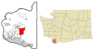
Hockinson is a census-designated place (CDP) in Clark County, Washington, United States. The population was 4,771 at the 2010 census.
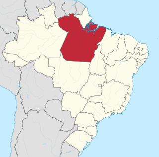
Pará is a state of Brazil, located in northern Brazil and traversed by the lower Amazon River. It borders the Brazilian states of Amapá, Maranhão, Tocantins, Mato Grosso, Amazonas and Roraima. To the northwest are the borders of Guyana and Suriname, to the northeast of Pará is the Atlantic Ocean. The capital and largest city is Belém, which is located at the Marajó bay, near the estuary of the Amazon river. The state, which is home to 4.1% of the Brazilian population, is responsible for just 2.2% of the Brazilian GDP.

Pedro Teixeira, occasionally referred to as the Conqueror of the Amazon, was a Portuguese explorer and military officer, who became, in 1637, the first European to travel up and down the entire length of the Amazon River, he also headed the government of the captaincy of Pará in two different periods, one in 1620-1621 and another in 1640–1641.

Bagua is a province of the Amazonas Region in Peru. It is located in the north and central part of the department of Amazonas. The region is known for its rugged terrain. It is also cut by deep gorges that have been formed by the important rivers that cross this province, as well as their numerous tributaries.

Sacramento is a Brazilian municipality located in the west of the state of Minas Gerais. Its population as of 2020 was 26,374 people living in a total area of 3,071 km². The city belongs to the meso-region of Triângulo Mineiro and Alto Paranaíba and to the micro-region of Araxá. It became a municipality in 1820.

Rio Espera is a municipality in Minas Gerais, Brazil.

The Zentrum Paul Klee is a museum dedicated to the artist Paul Klee, located in Bern, Switzerland and designed by the Italian architect Renzo Piano. It features about 40 percent of Paul Klee’s entire pictorial oeuvre.
Rabbitville is an unincorporated community in Marion Township, Lawrence County, Indiana.
Halfway River First Nation is a Dunneza First Nations government with a 3988 ha reserve located 75 km northwest of Fort St. John, British Columbia. It is a Treaty 8 nation.

The third principal meridian begins at the mouth of the Ohio River and extends north to the northern boundary of the state of Illinois, and with the base line in latitude 38° 28′ 20″, governs the surveys in the state east of the third principal meridian, with the exception of those projected from the second principal meridian, and the surveys on the west, to the Illinois River. This meridian is nearly coincident with 89° 10′ 15″ of west longitude from Greenwich.

Luisburgo is a Brazilian municipality located in the state of Minas Gerais. The city belongs to the mesoregion of Zona da Mata and to the microregion of Manhuaçu. As of 2020, the estimated population was 6,258.
Bagua District is one of six districts of the province Bagua in Peru. The district was created by law on April 26, 2008.
The Gates River is a short river in the Lillooet Country of the Southern Interior of British Columbia, Canada. Approximately 14.5 km in length, it flows generally northeast from the outlet of Birken Lake to its mouth at the head of Anderson Lake. Its main tributaries are Haylmore Creek, from the southeast, and Blackwater Creek, from the northwest, which originates near the head of Birkenhead Lake. Augmented by the waters of McGillivray Creek, Lost Valley Creek and others, its flow becomes the Seton River from the foot of Anderson Lake onwards.
Pine Island is an unincorporated community in Calhoun County, Florida, United States. It is located on State Road 69 north of Blountstown.

Bom Jesus do Amparo is a Brazilian municipality in the state of Minas Gerais. The city is part of the mesoregion Metropolitana de Belo Horizonte and the microregion of Itabira. As of 2020, the estimated population was 6,133.
Jutaizinho River is a river of Amazonas state in north-western Brazil. It is a tributary of the Jutaí River.
Caldas is a municipality in the state of Minas Gerais in the Southeast region of Brazil.

Pedra Preta is a municipality in the state of Mato Grosso in the Central-West Region of Brazil.
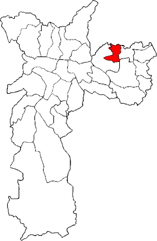
The Subprefecture of Ermelino Matarazzo is one of 32 subprefectures of the city of São Paulo, Brazil. It comprises two districts: Ermelino Matarazzo and Ponte Rasa. It hosts the second largest campus of University of São Paulo in the city.
Lewisville is an unincorporated community in the northeast corner of Harrison Township, Owen County, in the U.S. state of Indiana. It lies near the intersection of County Road 700 East and West Lewisville Road, which is a community about twenty miles northeast of the city of Spencer, the county seat. Its elevation is 771 feet, and it is located at 39°28′16″N86°37′55″W. This community lies on the border of Owen County and Morgan County.
References
Coordinates: 2°28′26″S46°26′24″W / 2.47389°S 46.44000°W