Fiji, officially the Republic of Fiji, is an island country in Melanesia, part of Oceania in the South Pacific Ocean. It lies about 1,100 nautical miles north-northeast of New Zealand. Fiji consists of an archipelago of more than 330 islands—of which about 110 are permanently inhabited—and more than 500 islets, amounting to a total land area of about 18,300 square kilometres (7,100 sq mi). The most outlying island group is Ono-i-Lau. About 87% of the total population live on the two major islands, Viti Levu and Vanua Levu. About three-quarters of Fijians live on Viti Levu's coasts, either in the capital city of Suva, or in smaller urban centres such as Nadi or Lautoka. The interior of Viti Levu is sparsely inhabited because of its terrain.

Lautoka is the second largest city in Fiji. It is on the west coast of the island of Viti Levu, in the Ba Province of the Western Division. Lying in the heart of Fiji's sugar cane-growing region, the city has come to be known as the Sugar City. Covering an area of 32 square kilometres, it had a population of 71,573 at the 2017 census, the most recent to date.

Viti Levu is the largest island in Fiji. It is the site of the country's capital and largest city, Suva, and home to a large majority of Fiji's population.

The Yasawa Group is an archipelago of about 20 volcanic islands in the Western Division of Fiji, with an approximate total area of 135 square kilometres (52 sq mi).

Sigatoka is a town in Fiji. It is on the island of Viti Levu at the mouth of the Sigatoka River, for which it is named, some 61 kilometres from Nadi. Its population at the 2017 census was 17,622. It is the principal urban centre for the province of Nadroga-Navosa.
Tavua is a town in Fiji, 91 kilometres from Nadi and 9 kilometres from the gold mining settlement of Vatukoula. It was formally incorporated as a Town in 1992 with the appointment of its first Mayor, Iliesa Vula from Tavualevu. The town covers a land area of 100 square kilometres, and had a population of 2,418 at the 1996 census.
Nadroga-Navosa is one of the fourteen provinces of Fiji and one of eight based in Viti Levu, Fiji's largest island. It is about 2,385 square kilometers and occupies the South-West and Central areas of Viti Levu, Fiji's principal island. The province includes the Mamanuca Archipelago,Malolo Islands, off the west coast of Viti Levu, Vatulele, as well as the remote Conway Reef in the southwest. The population at the 2017 census was 58,931, being the fifth largest province. The main town in Nadroga-Navosa is Sigatoka, with a population of 9622.
Ba is a province of Fiji, occupying the north-western sector of Viti Levu, Fiji's largest island. It is one of fourteen provinces in the nation of Fiji, and one of eight based in Viti Levu. It is Fiji's most populous province, with a population of 247,708 – more than a quarter of the nation's total – at the 2017 census. It covers a land area of 2,634 km2 (1,017 sq mi), the largest of any province.

Shangri-La's Fijian Resort is a luxury resort located at Yanuca Island, on Viti Levu island, Cuvu, Sigatoka, Fiji. Currently managed by Shangri-La Hotels and Resorts, the resort originally opened in 1967. After independence from the British, and going local was encouraged over expatriate management, Mr Andrew Thompson was appointed the first local General Manager at the young age of 27. He took the resort to new heights and since then, the fijian as it was known then has never looked back.
Nadi is a district within Ba Province, located on the south-west coast of the island of Viti Levu in Fiji. Nadi is well known for its international airport, which long provided a communication link for travellers from North America to Australia and New Zealand. Because of its proximity to the airport and a number of uninhabited tropical islands, tourism is the main industry in the district. The district is served by the town of Nadi which has a population of approximately 12,000. In the rural areas of Nadi most farmers are involved in the sugar cane industry.
Coral Coast may refer to:

The Sigatoka River is in the island of Viti Levu in Fiji and has its source on the west side of Mount Victoria and flows for 120 kilometers to the coast between the central and western ranges. It is the chief means of transportation with some parts of the interior of the island.
Rail transport in Fiji moves cut sugar cane to crushing mills. Also, there used to be two horse-drawn street tramway systems, some other passenger systems, an underground mine system, and some tramways on construction projects. There are multiple other modes of transport in Fiji.
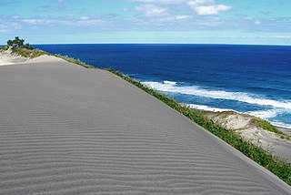
The Sigatoka Sand Dunes National Park is located at the mouth of the Sigatoka River on the island of Viti Levu in Fiji. They are located approximately 3 km west of the town of Sigatoka.
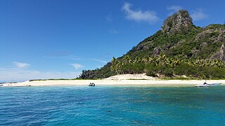
Monuriki is a small, uninhabited island situated off the coast of Viti Levu in the Fiji Islands, in Melanesia in the South Pacific Ocean. Monuriki is part of the Atolls islands, and related to a group of three islets in the larger group of islands known as the Mamanuca Islands. This coral and volcanic island is the smallest islet and the southernmost of a small group of three islets, west of Tavua.
Nagigia Island is an island located at the most south-western point of the Fiji Islands. It is also known on some charts and maps as Denham Island. The island has an area of 26 acres (11 ha), is privately owned and has a large sheltered lagoon suitable for snorkelling.
Mix FM is a radio station that serves Fiji, broadcasting on the FM band at the frequencies of 93.8 MHz in Lautoka, Nadi and Suva and 93.6 MHz in Ba, Tavua, Rakiraki and Sigatoka. The station has been licensed to broadcast all over Fiji since 2006. It launched in 2007. It is preferred by older urban populations.
Serua District is a district in Serua Province in Fiji.

Jasa Veremalua is a Fijian rugby union player who plays for the Tel Aviv Heat. He played for the San Diego Legion of Major League Rugby (MLR). He also plays for the Fiji sevens team. Veremalua made his debut for Fiji 7s at the 2013 Wellington Sevens. He is from Korotogo Village in the Nadroga Navosa Province.
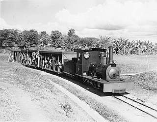
The Rarawai–Kavanagasau Light Railway was a narrow gauge railway in Fiji. It reached 142 miles (229 km) long.
