
Boca Raton is a city in Palm Beach County, Florida, United States. The population was 97,422 in the 2020 census and it ranked as the 23rd-largest city in Florida in 2022. However, many people with a Boca Raton postal address live outside of municipal boundaries, such as in West Boca Raton. As a business center, the city also experiences significant daytime population increases. Boca Raton is 45 miles (72 km) north of Miami and is a principal city of the Miami metropolitan area, which had a population of 6,138,333 at the 2020 United States Census.

Flagler County is a county located in the northeastern portion of the U.S. state of Florida. As of the 2020 census, the population was 115,378. Its county seat is Bunnell, and the largest city is Palm Coast. Created in 1917 from portions of Saint Johns and Volusia Counties, it was named for Henry Flagler, who built the Florida East Coast Railway.
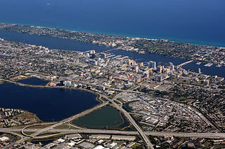
Palm Beach County is a county in the southeastern part of Florida, located in the Miami metropolitan area. It is Florida's third-most populous county after Miami-Dade County and Broward County and the 26th-most populous in the United States, with 1,492,191 residents as of the 2020 census. Its county seat and largest city is West Palm Beach, which had a population of 117,415 as of 2020. Named after one of its oldest settlements, Palm Beach, the county was established in 1909, after being split from Miami -Dade County. The county's modern-day boundaries were established in 1963.
Lauderdale-by-the-Sea is a town in Broward County, Florida, United States, situated 33 miles north of Miami. The town is part of the South Florida metropolitan area. As of the 2020 census, the population was 6,198.

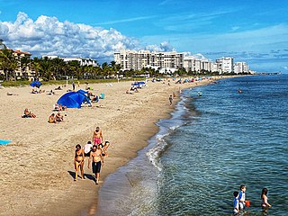
South Palm Beach is a town located in Palm Beach County, Florida, United States. The town is part of the Miami metropolitan area of South Florida and situated on a barrier island between the Atlantic Ocean and the Intracoastal Waterway. The entire town is approximately 5⁄8 of a mile (1.0 km) long along South Ocean Boulevard, its only street. It is between the Town of Palm Beach to the north and the Town of Lantana and its public beach to the south.
Tequesta is an incorporated village in Palm Beach County, Florida, United States. It is the northernmost municipality in the Miami metropolitan area, which according to the 2020 United States Census, had a total population of 6,138,333 South Florida residents. As of 2020, the US Census had the village's total at 6,158 of the population.

Palm Valley is a census-designated place (CDP) in St. Johns County, Florida, United States. The population was 19,860 at the 2000 census.

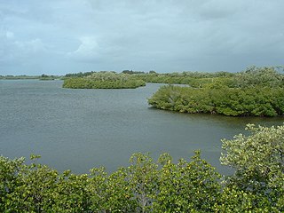
Biscayne Bay is a lagoon with characteristics of an estuary located on the Atlantic coast of South Florida. The northern end of the lagoon is surrounded by the densely developed heart of the Miami metropolitan area while the southern end is largely undeveloped with a large portion of the lagoon included in Biscayne National Park.
Sebastian Inlet State Park is a Florida state park located 10 miles south of Melbourne Beach and 6 miles north of Vero Beach in Florida. The park lies on both sides of the Sebastian Inlet, which forms the boundary between Brevard and Indian River counties. The land for the park was acquired by the state of Florida in 1971. In 2010, it was the second most visited state park in Florida.
Jupiter Island is a barrier island on the coast of Martin and Palm Beach counties, Florida. It is bounded on the east by the Atlantic Ocean, on the north by the St. Lucie Inlet, on the west by the Indian River, and on the south by the Jupiter Inlet. Jupiter Island originally was two islands, Long Island on the north and Jupiter Island on the south, which were once separated by an inlet in the vicinity of North Jupiter Narrows and what is officially called Peck Lake, but commonly called Peck's Lake.
The Canaveral Barge Canal is an active canal in Brevard County, Florida, cutting east-west across northern Merritt Island just south of Cape Canaveral. It connects the Atlantic Ocean and Port Canaveral with the Indian River and wider Indian River Lagoon, part of the Intracoastal Waterway. The canal consists of two segments separated by the Banana River.

The Hillsboro Canal is located in the southeastern portion of Florida within the South Florida Water Management District, and for much of its length forms the border between Broward and Palm Beach counties; however, its western end was entirely in Palm Beach County, until being recently annexed to Broward County-Parkland, FL. It begins at Lake Okeechobee at the S-2 water control structure in South Bay west of Belle Glade, Florida. It passes within the southern border of the Loxahatchee National Wildlife Refuge and flows southeast from there along Loxahatchee Road in a rural, lightly populated area. When it reaches the more heavily built-up region further east, it bends to head due eastward, forming the county line. Near its eastern end at the Intracoastal Waterway, with Boca Raton to the north and Deerfield Beach to the south, it departs from its straight course to go around several curves, but the county boundary continues to follow it at this point. 10 miles of the canal is navigable, and it is popular for recreational boating and fishing.

State Road 704 (SR 704), also known as Okeechobee Boulevard, is a 10.199-mile-long (16.414 km) east–west boulevard in the West Palm Beach area, known for being dangerous to pedestrians and bicyclists. It extends from an intersection with SR 7 at the border of West Palm Beach and Royal Palm Beach and just south of The Acreage at the western end to an intersection with SR A1A in Palm Beach at the east end.

The St. Lucie Inlet, Florida is located between Hutchinson Island and Jupiter Island in Martin County, Florida, at coordinates 27°09′58″N80°09′24″W. The St. Lucie Inlet is one of six inlets into the Indian River Lagoon.
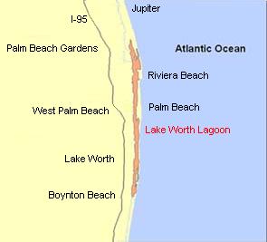
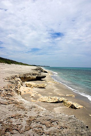
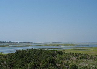
The Lake Worth Lagoon is a lagoon located in Palm Beach County, Florida. It runs parallel to the coast, and is separated from the Atlantic Ocean by barrier beaches, including Palm Beach Island. The lagoon is connected to the Atlantic Ocean by two permanent, man-made inlets.

Currituck Sound is a lagoon located in northeastern part of North Carolina and extreme southeastern Virginia.
Bogue Sound is a lagoon in the state of North Carolina separating the Bogue Banks, a 21-mile-long (34 km) barrier island, from the mainland. The sound is part of North Carolina's "Crystal Coast", a tourism marketing term that is also used interchangeably with the term "Southern Outer Banks." It is the southwestern-most sound among the interconnected series of sounds along the Outer Banks that starts in the northeast at Currituck Sound.

The Gumbo Limbo Environmental Complex, commonly known as the Gumbo Limbo Nature Center, is a nature center operated by the city of Boca Raton, Florida in conjunction with the Gumbo Limbo Coastal Stewards and the Greater Boca Raton Beach and Park District, and located at 1801 N. Ocean Blvd. in Boca Raton. Gumbo Limbo sits on twenty acres of protected barrier island, the area between the Intracoastal Waterway and the Atlantic Ocean. It is on land which is part of the beachfront-to-intracoastal Red Reef Park, though Gumbo Limbo does not have land directly on the beach. Its name comes from a popular name of the Bursera simaruba tree species, which is abundant in the park.
Juno Dunes Natural Area is a 576-acre (233 ha) nature preserve and park in Palm Beach County, Florida.
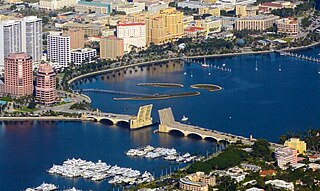
The Royal Park Bridge is a bascule bridge across the Intracoastal Waterway, linking Palm Beach and West Palm Beach, Florida. It gained widespread attention in February of 2022 when a woman fell to her death as its movable spans rose.

