Beringia is defined today as the land and maritime area bounded on the west by the Lena River in Russia; on the east by the Mackenzie River in Canada; on the north by 72 degrees north latitude in the Chukchi Sea; and on the south by the tip of the Kamchatka Peninsula. It includes the Chukchi Sea, the Bering Sea, the Bering Strait, the Chukchi and Kamchatka Peninsulas in Russia as well as Alaska in the United States.

Haida Gwaii is an archipelago approximately 45–60 km (30–40 mi) off the northern Pacific coast of Canada. The islands are separated from the mainland to the east by the shallow Hecate Strait. Queen Charlotte Sound lies to the south, with Vancouver Island beyond. To the north, the disputed Dixon Entrance separates Haida Gwaii from the Alexander Archipelago in the U.S. state of Alaska.

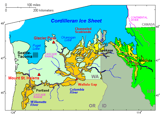
The Wisconsin Glacial Episode, also called the Wisconsin glaciation, was the most recent glacial period of the North American ice sheet complex. This advance included the Cordilleran Ice Sheet, which nucleated in the northern North American Cordillera; the Innuitian ice sheet, which extended across the Canadian Arctic Archipelago; the Greenland ice sheet; and the massive Laurentide Ice Sheet, which covered the high latitudes of central and eastern North America. This advance was synchronous with global glaciation during the last glacial period, including the North American alpine glacier advance, known as the Pinedale glaciation. The Wisconsin glaciation extended from approximately 75,000 to 11,000 years ago, between the Sangamonian Stage and the current interglacial, the Holocene. The maximum ice extent occurred approximately 25,000–21,000 years ago during the last glacial maximum, also known as the Late Wisconsin in North America.
Post-glacial rebound is the rise of land masses after the lifting of the huge weight of ice sheets during the last glacial period, which had caused isostatic depression. Post-glacial rebound and isostatic depression are phases of glacial isostasy, the deformation of the Earth's crust in response to changes in ice mass distribution. The direct raising effects of post-glacial rebound are readily apparent in parts of Northern Eurasia, Northern America, Patagonia, and Antarctica. However, through the processes of ocean siphoning and continental levering, the effects of post-glacial rebound on sea level are felt globally far from the locations of current and former ice sheets.
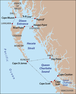
The Dixon Entrance is a strait about 80 kilometres (50 mi) long and wide in the Pacific Ocean at the Canada–United States border, between the U.S. state of Alaska and the province of British Columbia in Canada. It was named by Joseph Banks for Captain George Dixon, a Royal Navy officer, fur trader, and explorer, who surveyed the area in 1787. The Dixon Entrance is part of the Inside Passage shipping route. It forms part of the maritime boundary between the U.S. and Canada, although the location of that boundary here is disputed. A name used in the Haida language is Seegaay, which means only "ocean".

Hecate Strait is a wide but shallow strait between Haida Gwaii and the mainland of British Columbia, Canada. It merges with Queen Charlotte Sound to the south and Dixon Entrance to the north. About 87 miles (140 km) wide at its southern end, Hecate Strait narrows in the north to about 30 miles (48 km). It is about 160 miles (260 km) in length.

The Last Glacial Maximum (LGM) was the most recent time during the Last Glacial Period that ice sheets were at their greatest extent. Vast ice sheets covered much of North America, Northern Europe, and Asia and profoundly affected Earth's climate by causing drought, desertification, and a large drop in sea levels. According to Clark et al, growth of ice sheets commenced 33,000 years ago and maximum coverage was between 26,500 years and 19-20,000 years ago, when deglaciation commenced in the Northern Hemisphere, causing an abrupt rise in sea level. Decline of the West Antarctica ice sheet occurred between 14,000 and 15,000 years ago, consistent with evidence for another abrupt rise in the sea level about 14,500 ka ago.
The Laurentide Ice Sheet was a massive sheet of ice that covered millions of square kilometers, including most of Canada and a large portion of the northern United States, multiple times during the Quaternary glacial epochs, from 2.588 ± 0.005 million years ago to the present.

The Patagonian Ice Sheet was a large elongated and narrow ice sheet centered in the southern Andes that existed during the Llanquihue glaciation. The ice sheet covered all of Chile south of Puerto Montt plus the western fringes of Argentine Patagonia.
In glaciology, starvation occurs when a glacier retreats, not because of temperature increases, but due to precipitation so low that the ice flow downward into the zone of ablation exceeds the replenishment from snowfall. Eventually, the ice will move so far down that it either calves into the ocean or melts.

The British Columbia Coast or BC Coast is Canada's western continental coastline on the North Pacific Ocean. The usage is synonymous with the term West Coast of Canada.

Meltwater pulse 1A (MWP1a) is the name used by Quaternary geologists, paleoclimatologists, and oceanographers for a period of rapid post-glacial sea level rise, between 13,500 and 14,700 years ago, during which global sea level rose between 16 meters (52 ft) and 25 meters (82 ft) in about 400–500 years, giving mean rates of roughly 40–60 mm (0.13–0.20 ft)/yr. Meltwater pulse 1A is also known as catastrophic rise event 1 (CRE1) in the Caribbean Sea. The rates of sea level rise associated with meltwater pulse 1A are the highest known rates of post-glacial, eustatic sea level rise. Meltwater pulse 1A is also the most widely recognized and least disputed of the named, postglacial meltwater pulses. Other named, postglacial meltwater pulses are known most commonly as meltwater pulse 1A0, meltwater pulse 1B, meltwater pulse 1C, meltwater pulse 1D, and meltwater pulse 2. It and these other periods of rapid sea level rise are known as meltwater pulses because the inferred cause of them was the rapid release of meltwater into the oceans from the collapse of continental ice sheets.

The Insular Mountains are a range of mountains in the Pacific Coast Ranges on the Coast of British Columbia, Canada, comprising the Vancouver Island Ranges and Queen Charlotte Mountains. The Insular Mountains are rugged, particularly on Vancouver Island where peaks in Strathcona Provincial Park rise to elevations of more than 2000m (6,600 ft). The highest of these mountains is Golden Hinde on Vancouver Island, which rises to 2,196.818 m (7,207 ft).
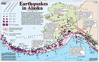
The Queen Charlotte Fault is an active transform fault that marks the boundary of the North American and the Pacific Plates. It is Canada's right-lateral strike-slip equivalent to the San Andreas Fault to the south in California. The Queen Charlotte Fault forms a triple junction on its south with the Cascadia subduction zone and the Explorer Ridge.

The Queen Charlotte Islands caribou or Dawson's caribou is an extinct subspecies of the reindeer that once lived on Graham Island, the largest of the Haida Gwaii islands in British Columbia, Canada. Possible causes of extinction include habitat destruction, introduced disease and overhunting. It was grey in appearance. The last three caribou were killed in 1908 and can be seen at the Royal British Columbia Museum, where their pelts and bones are preserved and displayed. Recent analysis of mtDNA suggests that the Queen Charlotte Islands caribou was not genetically distinct from the subspecies from the Canadian mainland.
The Haida Gwaii black bear, also known as the Queen Charlotte Islands black bear, is a morphologically distinct subspecies of the American black bear. The most significant morphological differences are its large size, massive cranium and large molars. This subspecies is endemic to the Haida Gwaii and is considered a "keystone species" because of the bears' transportation of salmon remains into the surrounding forests of the Haida Gwaii.
Deglaciation describes the transition from full glacial conditions during ice ages, to warm interglacials, characterized by global warming and sea level rise due to change in continental ice volume. Thus, it refers to the retreat of a glacier, an ice sheet or frozen surface layer, and the resulting exposure of the Earth's surface. The decline of the cryosphere due to ablation can occur on any scale from global to localized to a particular glacier. After the Last Glacial Maximum, the last deglaciation begun, which lasted until the early Holocene. Around much of Earth, deglaciation during the last 100 years has been accelerating as a result of climate change, partly brought on by anthropogenic changes to greenhouse gases.
The northern and southern hemispheres of the earth have a dynamic history of advancing and retreating ice sheets. The glacial and interglacial periods are linked to regular eccentricities in the Earth’s orbit and correspond to approximately 100 kyr cycles. The advancing, or glacial periods can cause a massive displacement of flora and fauna as it drives them away from the poles, with the most recent glacial maximum having occurred about 20,000 years ago.,

The Vashon Glaciation, Vashon Stadial or Vashon Stade is a local term for the most recent period of very cold climate in which during its peak, glaciers covered the entire Puget Sound and Strait of Juan de Fuca as well as present day Seattle, Tacoma, Olympia and other surrounding areas in the western part of present-day Washington (state) of the United States of America. This occurred during a cold period around the world known as the last glacial period. This was the most recent cold period of the Pleistocene Ice Age. The Pleistocene Glaciation is the ice age that the planet is currently in and has been in for the last 2.58 million years. It is the time period in which the arctic ice sheets have existed. The Pleistocene Ice Age is part of an even longer ice age called the Late Cenozoic Ice Age, which began 33.9 million years ago and is ongoing. It is the time period in which the Antarctic ice cap has existed.
The coastal migration hypothesis is one of two possibilities in the settlement of the Americas at the time of the Last Glacial Maximum. It proposes a migration route involving watercraft, via the Kurile island chain, along the coast of Beringia and the archipelagos off the Alaskan-British Columbian coast, continuing down the coast to Central and South America. The alternative is the "interior route", which assumes migration along an ice-free corridor between the Laurentide and Cordilleran ice sheets during the Last Glacial Maximum.