
Urlingford is a town in County Kilkenny, Ireland. It is also a civil parish within the barony of Galmoy. The town is in the north west of the county, along the boundary with County Tipperary, 16 km north-east of Thurles.

Johnstown, historically known as Coorthafooka, is a small town in County Kilkenny, Ireland. Bypassed in December 2008 by the M8, the town lies at the junction of the R639, the R502 and the R435 regional roads. It is the home of the Fenians GAA hurling club. Situated 121 kilometres (75 mi) from Dublin and 131 kilometres (81 mi) from Cork, it lies in the agricultural heartland of the southeast.
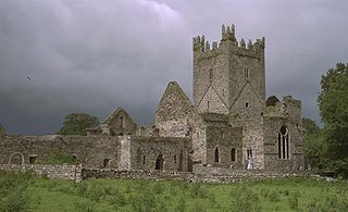
Jerpoint Abbey is a ruined Cistercian abbey, founded in the second half of the 12th century in County Kilkenny, Ireland. It is located 2.5 km south west of Thomastown on the R448 regional road. There is a visitor centre with an exhibition. It has been declared a national monument and has been in the care of the Office of Public Works since 1880.

Mooncoin is an urban area in County Kilkenny, in Ireland. The population was 1,175 in 2016. Historically part of the Gaelic kingdom of Osraige, today it is in the far south of the county of Kilkenny, located in the valley of the River Suir. It is surrounded by the uplands of the Slievenamon and Comeragh Mountains, just 10 kilometres (6.2 mi) north of Waterford City along the N24 national primary road, and it is 48 kilometres (30 mi) south of Kilkenny.
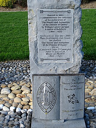
William Carrigan was an Irish Roman Catholic priest and historian, who was appointed canon of the Diocese of Ossory.

Killamery is a village in County Kilkenny, Ireland. Located near the County Tipperary border, it is in a townland and civil parish of the same name. Killamery lies on the N76 national secondary road, halfway between Kilkenny to the northeast and Clonmel to the southwest.
Carrigeen is a village to the south-east of Mooncoin in County Kilkenny, Ireland. Carrigeen is situated on a hillock within the Suir Valley. Within the village is St. Kevin's Church and a national (primary) school. The grounds of Carrigeen GAA club are nearby.

Ida is a barony in the south-east of County Kilkenny, Ireland. Ida is made up of 16 civil parishes containing 191 townlands, it is one of 12 baronies in the County. The barony is 249.8 square kilometres (96.4 sq mi) in size, with highest point at Tory Hill. The chief town is Slieveroe. The N25 crosses the barony.

The history of Kilkenny began with an early sixth-century ecclesiastical foundation, this relates to a church built in honour of St. Canice, now St. Canice's Cathedral and was a major monastic centre from at least the eighth century. The Annals of the Four Masters recorded the first reference Cill Chainnigh in 1085. Prehistoric activity has been recorded suggesting intermittent settlement activity in the area in the Mesolithic and Bronze Age. Information on the history of Kilkenny can be found from newspapers, photographs, letters, drawings, manuscripts and archaeology. Kilkenny is documented in manuscripts from the 13th century onwards and one of the most important of these is Liber Primus Kilkenniensis.
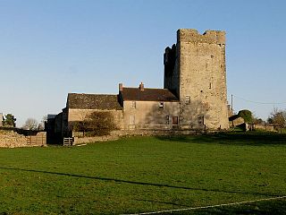
Kilbline Castle is a fortified 16th century tower house in County Kilkenny in Ireland. It is set on the Kilbline Estate in the parish of Tullaherin, within the historical barony Gowran, approximately 1 mile southeast of Bennettsbridge. It is recorded as a protected (listed) structure by Kilkenny County Council.
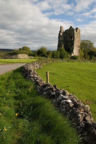
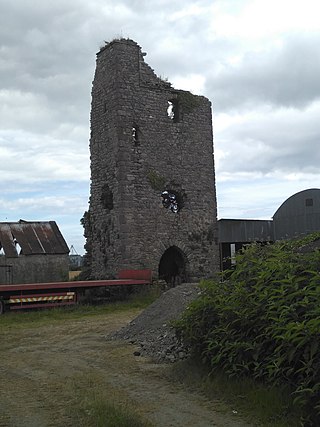
Cullahill Castle was the principal stronghold of the MacGillapatricks of Upper Ossory built around 1425 and destroyed around 1650. Cullahill Castle takes its name from an ancient forest that covered Cullahill Mountain and extended down to Cullahill village.

Crannagh, sometimes written Cranagh or Granagh, is a barony in the north western part of County Kilkenny, Ireland. It is one of 12 baronies in County Kilkenny. The size of the barony is 210.8 square kilometres (81.4 sq mi). There are 19 civil parishes in Crannagh, made up of 182 townlands. The chief town Freshford, with highest point at Clomantagh Hill. Crannagh lies at the north west of the county, with the baronies of Galmoy and Fassadinin to the north, and the barony of the Kilkenny to the east and Shillelogher to the south. It is buffers County Tipperary on the west. The R693 road crosses the barony.

St. Mary’s Collegiate Church Gowran, also known as the Church of the Blessed Virgin of the Assumption, is a church in the centre of the town of Gowran, County Kilkenny, Ireland. The site is a National Monument in the care of the Gowran Development Association (GDA) and the Office of Public Works (OPW). The church and its family connections have been of huge importance to Gowran and further afield over the centuries. The church is a collegiate church, which means that the priests or chaplains attached to it lived in community together. The present church was not a monastery or an abbey; however experts believe the church was built on the site of an earlier monastery. The presence of an Ogham stone on the site, which is on display in the chancel, suggests there was a place of worship here dating back 2000 years to Celtic times or beyond.
Gowran is a barony in the east of County Kilkenny, Ireland. The size of the barony is 430.5 square kilometres (166.2 sq mi). There are 35 civil parishes in Gowran. The chief town today is Gowran. The barony contains the ecclesiastical sites of Kilfane and Duiske Abbey The barony of Gowran is situated in the east of the county between the baronies of Fassadinin to the north, the baronies of Kilkenny, Shillelogher and Knocktopher to the west, and the barony of Ida is to the south. It borders County Carlow to the east. The M9 motorway bisects the barony.
Kells is a barony in the south-west of County Kilkenny, Ireland. It is one of 12 baronies in County Kilkenny. The size of the barony is 155.6 square kilometres (60.1 sq mi). There are 10 civil parishes in Kells, made up of 167 townlands. The chief town is Kells.
Gorteens Castle is a ruined castle situated on private land in south-east County Kilkenny near the village of Slieverue close to Waterford city. It is in the historic parish of Rathpatrick in the south-east of the Barony of Ida. Along with the ruins of Rathpatrick church and another church, it is one of several ruins in Rathpatrick Parish.

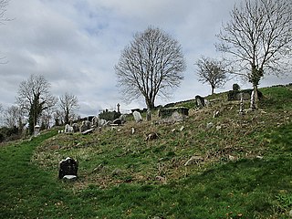
Grangefertagh is a former abbey located in County Kilkenny, Ireland. It is today a National Monument.

Cantwell's Castle is a tower house located in the townland of Sandfortscourt in County Kilkenny, Ireland. It served as the main residence for the head of the Cantwell family, While debated of who owned it in its final days the facts point to the Cantwell Family. Before a siege of the Cantwell castle from Oliver Cromwells army which led to Cromwells army being forced away with the Cantwells taking control even though two of the three castles were significantly damaged.
Columbkille is a civil parish and townland in County Kilkenny, Ireland. Located near Thomastown, it is in the historical barony of Gowran. Evidence of historical settlement in Columkille townland itself include a number of fulacht fiadh sites, a reputed holy well, and a graveyard and ruined church in an ecclesiastical enclosure. Other townlands within Columbkille civil parish include Ballyroe, Carrickmourne, Dangan, Jackstown, Kilcullen, Kiljames, Kilmurry, Ruppa and Mungmacody.

Aughatubbrid, also known as Chatsworth, is a townland in County Kilkenny, Ireland. The townland, which has an area of approximately 6.63 square kilometres (2.56 sq mi), is in the civil parish of Castlecomer. The village and townland of Clogh is to the east. As of the 2011 census, Aughatubbrid had a population of 331 people.
