Corozal Bay is an inlet of Chetumal Bay, indenting northern Belize. Several resort areas are located on the coast of the bay, most notably Corozal Town. The New River (Belize) flows north into the bay. The town of Consejo is located north-northeast of the bay, on the much larger Chetumal Bay. The Mayan ruins of Cerros are located on the bay.
Chetumal Bay is a large bay of the western Caribbean Sea on the southern coast of the Yucatán Peninsula.
Belize is a country located on the eastern coast of Central America. Belize is bordered on the northwest by Mexico, on the east by the Caribbean Sea, and on the south and west by Guatemala. It has an area of 22,970 square kilometres (8,867 sq mi) and a population of 387,879 (2017). Its mainland is about 180 mi (290 km) long and 68 mi (110 km) wide. It has the lowest population and population density in Central America. The country's population growth rate of 1.87% per year (2015) is the second highest in the region and one of the highest in the Western Hemisphere.
Corozal Town is a town in Belize, capital of Corozal District. Corozal Town is located about 84 miles north of Belize City, and 9 miles from the border with Mexico. The population of Corozal Town, according to the main results of the 2010 census, is 9,871. Corozal was a private estate before becoming a town in the 1840s, mostly settled by Maya Mestizo refugees from the Caste War of Yucatán. Much of the town was built over an ancient Maya city, sometimes known as Santa Rita; this may have been the original Pre-Columbian town called Chetumal. Corozal Town was badly damaged by Hurricane Janet in 1955, and was substantially rebuilt afterwards.
A geographic coordinate system is a coordinate system that enables every location on Earth to be specified by a set of numbers, letters or symbols. The coordinates are often chosen such that one of the numbers represents a vertical position and two or three of the numbers represent a horizontal position; alternatively, a geographic position may be expressed in a combined three-dimensional Cartesian vector. A common choice of coordinates is latitude, longitude and elevation. To specify a location on a plane requires a map projection.
This article about the geography of Belize is a stub. You can help Wikipedia by expanding it.
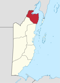
Corozal District is the northernmost district of the nation of Belize. The population was 33,335 in 2000. The district capital is Corozal Town.
San Estevan was the first town in the Orange Walk District of the nation of Belize but later became a village due to migration of villagers to other parts of the country during a great epedimic. According to the 2010 census, it had a population of 1,573 people. The village is approximately 6 miles northeast from Orange Walk Town.
Louisville is a village in the Corozal District of the nation of Belize, located at 18°19′N88°30′W. According to the 2000 census, it had a population of 655 people mainly from Maya Mestizo ancestry.
Xaibe is small rural settlement in the country of Belize mainly consisting of people from the Yucatec Maya ethnicity. It is located in Corozal District. The name Xaibe literally means 'crossroads'. The people of the Maya civilization often traversed across the village to reach other Maya villages. The population of the village is very small. The last available data of the population of Xaibe in 2010 revealed that it had a modest population of approximately 1,575 people. There is, however, evidence of the fact that the people belonging to the Maya civilization resided in the Xaibe village. These people then gradually shifted to Mexico, just across the border at the time of the Caste War of Yucatán. The village is known for celebrating the Maya tradition Hanal Pixan which means "food for the souls" also known as Day of the Dead.
Consejo is a village in the north of Corozal District, Belize. Consejo is located on a point of land where the bays of Corozal and Chetumal meet. Consejo is about 8 miles from the district capital of Corozal Town, and 2 miles (3.2 km) across the water from Chetumal, Mexico.
The House of Representatives of Belize is one of two chambers of the National Assembly, the other being the Senate. It was created under the 1981 constitution. Members are commonly called "Area Representatives."
Corozal Airport is an airport that serves Corozal, Belize. It is located at the south entrance of Corozal, in Ranchito village, and is therefore known as Ranchito Airport.
Sarteneja Airport is an airport serving Sarteneja, a town in the Corozal District in northern Belize. The airport is just east of the town, which is on Chetumal Bay.
Calcutta is a village in the Corozal District of Belize.
Copper Bank is a fishing village in the Corozal District of Belize. It is situated on the west bank of Laguna Seca, a shallow lagoon that empties into Chetumal Bay just north-east of the village. The closest settlement is Chunox, located approximately 1.25 miles away on the east bank of the Laguna Seca.
The New River, also Rio Nuevo, is a river in northern Belize. As the longest river that is entirely confined to Belize, it drains primarily the eastern part of the Orange Walk District during its north-northeasterly course and empties into the Chetumal Bay. The river also forms the New River Lagoon, the largest body of fresh water in Belize, just east of the Maya temples of Lamanai. The New River is a habitat for numerous types of fish, birds, as well as crocodiles.
The Belize–Mexico border is an international border between Belize and Mexico. It is 250 km long and almost exclusively follows the course of the Hondo River. It separates Belize from the Mexican states of Quintana Roo and Campeche.
Santa Rita is a Maya ruin and an archaeological reserve on the outskirts of Corozal, Belize. Historical evidence suggests that it was probably the ancient and important Maya city known as Chetumal.
Orange Walk Airport is a public use airport 3 kilometres (2 mi) southwest of Orange Walk Town, Orange Walk District, Belize. The airport was also known as Tower Hill Airport.
Yo Chen is a small village located in the Corozal District from the nation of Belize. The name Yo Chen is in the Yucatec Maya language which means " Top of the well". Most of Yo Chen residences are from Maya Yucatec descent.
Johnny Chan Chen Airstrip is an airport serving Chan Chen, a village in the Corozal District of Belize. The airport is 1.6 kilometres (1 mi) west of Chan Chen and 7 kilometres (4.3 mi) northwest of Corozal.
This page is based on this Wikipedia article Text is available under the CC BY-SA 4.0 license; additional terms may apply. Images, videos and audio are available under their respective licenses.